

View Information About HSR Ratings
This bridge is in a unique setting. It is one of two different historic truss bridges that share an earthen pier in the middle of this wide, swampy section of the Raritan river. The two bridges are thus within sight of each other, yet are two different bridges with different builders. Each is historically significant. This setting with two unique bridges makes for a beautiful arrangement that deserved to be preserved. The Historic Bridge Inventory recognized the significance of this unique situation and listed the two bridges as a single historic resource eligible for the National Register of Historic Places, rather than two separate historical resources. Due to their design differences however, they are presented as separate structures on HistoricBridges.org. Click here to visit the page for the other bridge.
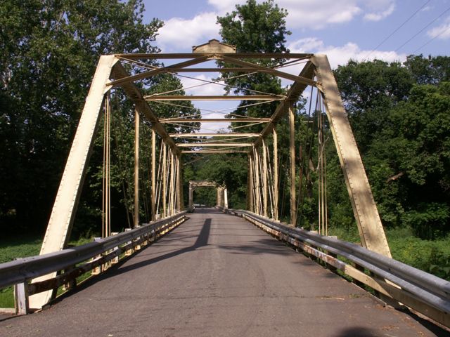
This bridge was painted an attractive cream color, which is a nice change from the darker colors that so often are painted on truss bridges which are preserved, such as those many olive green bridges seen in the interior of Hunterdon County, which blend right into the trees making them difficult to photograph.
This bridge was built by the Wrought Iron Bridge Company, one of the most prolific bridge companies of the late 19th century.
The bridge has been altered/rehabilitated with added tension bars. However, this work did not weld materials to the original eyebars or connection points. As such, the original bridge material and design was not compromised, and as such these alterations are much less adverse than alterations seen on truss bridges elsewhere in New Jersey. The main area in which original bridge material and design has been removed is several locations on the bridge where rivets were replaced with bolts.
As such, this bridge is significant as a complete, representative example of a traditional bridge type built by a prolific bridge builder.
Information and Findings From New Jersey's Historic Bridge InventoryDiscussion of Bridge SUMMARY: The 7-panel pin-connected half hip Pratt thru truss bridge is one of the most complete examples of its type in Somerset County. It is supported on ashlar abutments. The verticals are composed of laced channels while the top chord and end posts are built-up box members. The most distinctive construction detail is the 4-prong basket loop on the bottom of the floor beam hangers for making the connection at the pin. The bridge is eligible because of its age and integrity of setting and design. BIBLIOGRAPHY:
Darnell, Victor. Directory of American Bridge Building Companies
1840-1900. Washington, DC: Society for Industrial Archeology, 1984. PHYSICAL DESCRIPTION: The 7-panel pin-connected half hip Pratt thru truss bridge carries a single lane roadway over the flood plain and auxiliary channel of the South Branch of the Raritan River. Composed of rolled sections, the top chords and end posts consist of a built-up box member, and the lower chords are paired eye bars. The verticals are toe-in channels with lacing, except for the hip vertical which is a bar. The diagonals are paired bars and the counters single bars. The I-beam floor beams are connected to the verticals by Ushaped hangers. One of the most distinctive features of the bridge is the 4-prong basket loop on the bottom of the hip verticals for making the connection to the pin. The upper struts are I-beams, and the upper laterals are rods with turnbuckles. The portal bracing, which is composed of angles, carries a makers plaque. The bridge shows few signs of alterations except for the replacement of some riveted connections with bolts along the lower chord, and the replacement of the original railing with a beam guide rail. Bridge cards from the Hunterdon County engineer's office indicate no major repairs between 1940 and 1960 except for the routine replacement of the deck. It is not known whether the bridge is composed of steel and/or iron members. The bridge is exceptionally well preserved. HISTORICAL AND TECHNOLOGICAL SIGNIFICANCE: The Pratt truss was the most common late-19th century truss bridge type, but few examples in the region are as complete as the Higginsville Road span. It survives in basically unaltered condition and is thus an important example of 19th-century technology and construction techniques. The bridge works in tandem with the 1890 Pratt thru truss fabricated by Milliken Brothers of New York City. That span (18A0601) is immediately northeast, and the two share a common large earthfilled abutment. The bridge was designed and fabricated by the Wrought Iron Bridge Company of Canton, Ohio. Organized in 1864 by David Hammond, the company was one of the first wrought iron truss manufacturers, and continued in existence for 36 years before being absorbed by the giant American Bridge Company in 1900. The company claimed in its promotional literature to have constructed trusses in 30 states, mostly east of the Mississippi River. In Canton, the fabricator had shops for the drafting, laying out, shearing, drilling, punching, and riveting of truss members, but did not roll its own iron or steel. The Wrought Iron Bridge Company was recognized as one of the most significant regional manufacturers of iron and steel trusses because of its workmanship and prolificacy. Unlike many of its competitors, the Wrought Iron Bridge Company did not specialize in one truss type, but constructed a wide diversity of small and large, inexpensive and expensive truss types, depending upon local preferences. According to the company's 1885 trade catalogue, at least 10 other Wrought Iron Bridge Company trusses were built in New Jersey prior to 1885, six in Middlesex County, three in Mercer County, and one in Union County. One other Wrought Iron Bridge Co. bridge is known to survive in Somerset County, the well-preserved Nevius Street Bridge (1886), a two-span double-intersecting Pratt thru truss across the Raritan River in the town of Raritan. The Wrought Iron Bridge Co. was one of the most successful of the many small designers/fabricators who dominated 19th-century bridge construction. The Higginsville Road Bridge is an important example of their craftsmanship, as well as a locally significant example of a bridge type that was once common in Somerset County. Boundary Description and Justification: This span and the adjacent span (18A0601) are considered as one 2-span resource that is individually distinguished. The boundary is limited to the superstructure and substructure of the 2-span bridge, although the bucolic character of the setting does enhance the context. Discussion of Surrounding Area The southernmost of the pair of similar early bridges, this span carries a narrow country road over flood plain and auxiliary channel of the river. It enjoys an unspoiled picturesque rural setting just east of an equally pristine crossroads settlement that sprang up around a waterpowered mill (Higgins Mill). The surrounding land use is predominantly agricultural. The two bridges (18A0601) share a common earthen abutment, and they are on the county line. Bridge Considered Historic By Survey: Yes |
![]()
![]()
![]()
Coordinates (Latitude, Longitude):
Search For Additional Bridge Listings:
Bridgehunter.com: View listed bridges within 0.5 miles (0.8 kilometers) of this bridge.
Bridgehunter.com: View listed bridges within 10 miles (16 kilometers) of this bridge.
Additional Maps:
Google Streetview (If Available)
GeoHack (Additional Links and Coordinates)
Apple Maps (Via DuckDuckGo Search)
Apple Maps (Apple devices only)
Android: Open Location In Your Map or GPS App
Flickr Gallery (Find Nearby Photos)
Wikimedia Commons (Find Nearby Photos)
Directions Via Sygic For Android
Directions Via Sygic For iOS and Android Dolphin Browser
USGS National Map (United States Only)
Historical USGS Topo Maps (United States Only)
Historic Aerials (United States Only)
CalTopo Maps (United States Only)

© Copyright 2003-2025, HistoricBridges.org. All Rights Reserved. Disclaimer: HistoricBridges.org is a volunteer group of private citizens. HistoricBridges.org is NOT a government agency, does not represent or work with any governmental agencies, nor is it in any way associated with any government agency or any non-profit organization. While we strive for accuracy in our factual content, HistoricBridges.org offers no guarantee of accuracy. Information is provided "as is" without warranty of any kind, either expressed or implied. Information could include technical inaccuracies or errors of omission. Opinions and commentary are the opinions of the respective HistoricBridges.org member who made them and do not necessarily represent the views of anyone else, including any outside photographers whose images may appear on the page in which the commentary appears. HistoricBridges.org does not bear any responsibility for any consequences resulting from the use of this or any other HistoricBridges.org information. Owners and users of bridges have the responsibility of correctly following all applicable laws, rules, and regulations, regardless of any HistoricBridges.org information.
![]()