

View Information About HSR Ratings

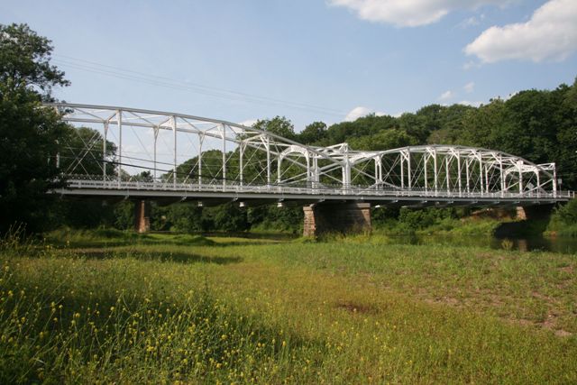
This bridge is one of only two known lenticular truss bridges in the state, and is the most significant of the two. It is a noteworthy example of its type because it is a multi-span example. The bridge displays the classic lenticular shape and ornatmental details of its patent-holding builder, Berlin Iron Bridge Company, with the ornate portal bracing and equally ornate builder plaque, and highly decorative pedestrian railings.
There is an odd welded portal-like construct in front of the bridge's original portals, which apparently dates back to the 1930s.
This historic bridge has been rehabilitated and preserved twice, once in 1984, and again in 2007. Some aspects of these rehabilitations were very sensitive to the historic character of the bridge and are commendable, while others seem like they harmed the character of the bridge significantly.
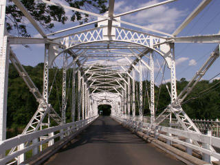
Some of the positive aspects of the rehab included avoiding the use of welded plates on the bridge, and supplementing original tension members with new members, rather than removing and replacing the original members. Also, the rehab maintained the design and function of the pin connections; the pins were replaced with new pins, not bypassed with a new system. Numerous rivets have been replaced with modern bolts, which is not preferable, however round-head bolts were used, which helps reduce the visual impact of the bolts, making at least half each bolt look like a rivet. Low profile, vehicular guiderails placed on the bridge are designed to protect the truss structure from collision damage, which is excellent. Finally, the original ornate sidewalk railings have been preserved in their original condition.
On the other hand, there were some negative aspects of the rehabilitation. Floorbeams on the bridge are not original and are all modern rolled beams, marking a significant loss to the beauty of the bridge. The original beams on this bridge were unusual rolled beams with tension rods mounted below them, making them extremely rare and unusual floorbeams. Photos of the original floorbeams are available here. Their replacement is a significant loss. The entire top chord has had a strengthening beam placed inside the box section. While this is a great way to strengthen the bridge, the attractive v-lacing that would originally have been on the underside of the top chord was removed. It would have been nice to see the v-lacing re-attached after the strengthening beam was inserted.
All that said, it is great to see a historic metal truss bridge preserved and continuing to serve vehicular traffic safely and effectively. Driving across a lenticular truss bridge is a very enjoyable experience, and thanks to the preservation of this bridge it will continue to be possible to have this experience in New Jersey.
Information and Findings From New Jersey's Historic Bridge InventoryDiscussion of Bridge The 2-span lenticular truss bridge is one of the best surviving examples of the late-19th century truss type that was successfully marketed nationally by the Berlin Iron Bridge Company of Connecticut. It is a variation on the Pratt truss and is distinguished by its polygonal top and bottom chords. The end posts have been encased in concrete, and the bridge was strengthened in 1983, but it retains its integrity of original design. It is also a contributing element in a historic district. Discussion of Surrounding Area The bridge carries a single lane over the river in the late-19th century community of Neshanic Station. The original setting of the bridge is well preserved. It is a contributing element in the Neshanic Mills Historic District. The lenticular truss bridge is in full view of another historically significant span, the 1896 pin-connected Pratt thru truss that carries the South Branch of the Central Railroad of New Jersey over the river. Bridge Considered Historic By Survey: Yes |
![]()
![]()
![]()
Coordinates (Latitude, Longitude):
Search For Additional Bridge Listings:
Bridgehunter.com: View listed bridges within 0.5 miles (0.8 kilometers) of this bridge.
Bridgehunter.com: View listed bridges within 10 miles (16 kilometers) of this bridge.
Additional Maps:
Google Streetview (If Available)
GeoHack (Additional Links and Coordinates)
Apple Maps (Via DuckDuckGo Search)
Apple Maps (Apple devices only)
Android: Open Location In Your Map or GPS App
Flickr Gallery (Find Nearby Photos)
Wikimedia Commons (Find Nearby Photos)
Directions Via Sygic For Android
Directions Via Sygic For iOS and Android Dolphin Browser
USGS National Map (United States Only)
Historical USGS Topo Maps (United States Only)
Historic Aerials (United States Only)
CalTopo Maps (United States Only)

© Copyright 2003-2025, HistoricBridges.org. All Rights Reserved. Disclaimer: HistoricBridges.org is a volunteer group of private citizens. HistoricBridges.org is NOT a government agency, does not represent or work with any governmental agencies, nor is it in any way associated with any government agency or any non-profit organization. While we strive for accuracy in our factual content, HistoricBridges.org offers no guarantee of accuracy. Information is provided "as is" without warranty of any kind, either expressed or implied. Information could include technical inaccuracies or errors of omission. Opinions and commentary are the opinions of the respective HistoricBridges.org member who made them and do not necessarily represent the views of anyone else, including any outside photographers whose images may appear on the page in which the commentary appears. HistoricBridges.org does not bear any responsibility for any consequences resulting from the use of this or any other HistoricBridges.org information. Owners and users of bridges have the responsibility of correctly following all applicable laws, rules, and regulations, regardless of any HistoricBridges.org information.
![]()