

View Information About HSR Ratings
This bridge is one of two historic truss bridges within sight of each other, but of vastly different eras on this road, the other one is the eastern western bridge.
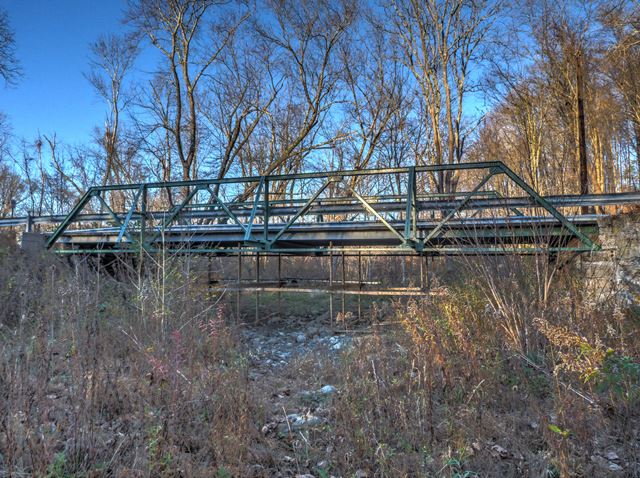
1902 was the construction date given for this bridge. The accuracy of this date is not known, this would make the bridge an early example of its type. Stylistically, the bridge has the appearance of a ca. 1915 bridge.
During documentation by HistoricBridges.org, the bridge was being repainted.
Information and Findings From New Jersey's Historic Bridge InventoryDiscussion of Bridge The rivet-connected Warren pony truss bridge is supported on one ashlar abutment with a concrete cap and one concrete abutment. Many of the original riveted members have been strengthened with the addition of welded plates, but not the top chord. The bottom chord has been strengthened with an additional angle section. Outriggers have been welded to the chords and at the midpoint of the verticals. The bridge is a relatively well-represented type, and it has been significantly altered. Discussion of Surrounding Area The bridge is located in a wooded area that is sparsely developed. It carries a one-lane road over an intermittent stream that is a branch of Paulins Kill. Another pony truss bridge (2101313) is located 100' to the north, carrying the same one-lane road over Paulins Kill. Bridge Considered Historic By Survey: No |
![]()
![]()
![]()
Coordinates (Latitude, Longitude):
Search For Additional Bridge Listings:
Bridgehunter.com: View listed bridges within 0.5 miles (0.8 kilometers) of this bridge.
Bridgehunter.com: View listed bridges within 10 miles (16 kilometers) of this bridge.
Additional Maps:
Google Streetview (If Available)
GeoHack (Additional Links and Coordinates)
Apple Maps (Via DuckDuckGo Search)
Apple Maps (Apple devices only)
Android: Open Location In Your Map or GPS App
Flickr Gallery (Find Nearby Photos)
Wikimedia Commons (Find Nearby Photos)
Directions Via Sygic For Android
Directions Via Sygic For iOS and Android Dolphin Browser
USGS National Map (United States Only)
Historical USGS Topo Maps (United States Only)
Historic Aerials (United States Only)
CalTopo Maps (United States Only)

© Copyright 2003-2025, HistoricBridges.org. All Rights Reserved. Disclaimer: HistoricBridges.org is a volunteer group of private citizens. HistoricBridges.org is NOT a government agency, does not represent or work with any governmental agencies, nor is it in any way associated with any government agency or any non-profit organization. While we strive for accuracy in our factual content, HistoricBridges.org offers no guarantee of accuracy. Information is provided "as is" without warranty of any kind, either expressed or implied. Information could include technical inaccuracies or errors of omission. Opinions and commentary are the opinions of the respective HistoricBridges.org member who made them and do not necessarily represent the views of anyone else, including any outside photographers whose images may appear on the page in which the commentary appears. HistoricBridges.org does not bear any responsibility for any consequences resulting from the use of this or any other HistoricBridges.org information. Owners and users of bridges have the responsibility of correctly following all applicable laws, rules, and regulations, regardless of any HistoricBridges.org information.
![]()