

View Information About HSR Ratings
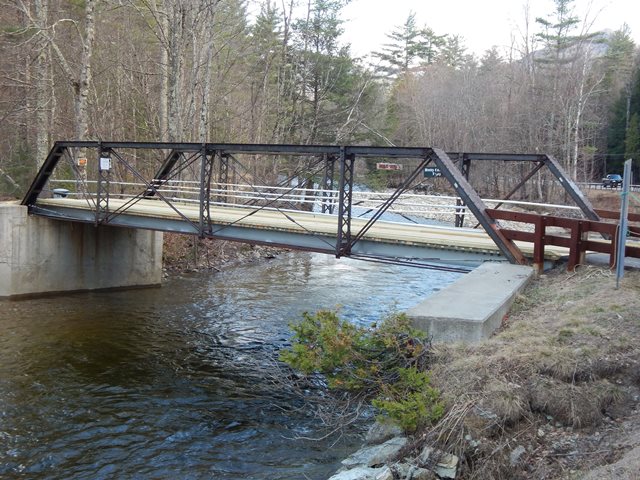
This is a classic example of a pony truss built by the Groton Bridge Company. This bridge is on a private road, but is right next to a public road.
A ca. 1900 construction date was given, but the design was a standard one used by Groton Bridge Company in the 1890s.
The bridge was originally located in the town of Lewis, about 15 miles northeast of Keene Valley and moved here by Fedor Smith and Paul Sachs in ca. 1925. The exact location is unknown.
The bridge is the only access across the East Branch of the Ausable River to six residential properties. It is a one lane bridge. It is on the National Register.
The area around this bridge was subjected to hurricane-related flooding and in 2020 the owners were applying for "Beers Bridge Preservation" per the NYS Cultural Resources Information System as follows:
The application being submitted is for “Beers Bridge Preservation”. The bridge provides the only vehicle access to six residential properties in the Town of Keene. The bridge itself is on the National Register of Historic Places (98NR013347) and has been documented in “Crossing the River, The Historic Bridges of the Ausable River” by Steven Engelhart, Executive Director of Adirondack Architectural Heritage (AARCH).
The bridge and road begin from NYS Route 73 and are initially on the property of Laura Booth and Jennifer Cook. However, the agreements dating back to the 1950’s, and the deeds for the various properties bind the neighbors to share in the costs of upkeep and allow passage of others on their sections. As a result, while the work will be entirely on Ms. Booth’s and Ms. Cook’s property, it is undertaken on behalf of and in agreement with all the neighbors.
As you will see in the report and design proposal by Schoder Rivers Associates, the bridge is threatened by the severe erosion of the East bank of the East Branch of the Ausable River. This erosion is due to the high water events of Hurricane Irene and the 2019 Halloween storm and has been accelerated by high water events in mid-January 2020 and mid-April 2020.
Our proposal is intended to protect the bridge from catastrophic loss which would eliminate the access to the residential properties. These represent more than $2.5 million of assessed value in the Town of Keene.
This bridge is tagged with the following special condition(s): Unorganized Photos
![]()
![]()
![]()
This bridge is on a private road, but is right next to a public road.
Coordinates (Latitude, Longitude):
Search For Additional Bridge Listings:
Bridgehunter.com: View listed bridges within 0.5 miles (0.8 kilometers) of this bridge.
Bridgehunter.com: View listed bridges within 10 miles (16 kilometers) of this bridge.
Additional Maps:
Google Streetview (If Available)
GeoHack (Additional Links and Coordinates)
Apple Maps (Via DuckDuckGo Search)
Apple Maps (Apple devices only)
Android: Open Location In Your Map or GPS App
Flickr Gallery (Find Nearby Photos)
Wikimedia Commons (Find Nearby Photos)
Directions Via Sygic For Android
Directions Via Sygic For iOS and Android Dolphin Browser
USGS National Map (United States Only)
Historical USGS Topo Maps (United States Only)
Historic Aerials (United States Only)
CalTopo Maps (United States Only)

© Copyright 2003-2026, HistoricBridges.org. All Rights Reserved. Disclaimer: HistoricBridges.org is a volunteer group of private citizens. HistoricBridges.org is NOT a government agency, does not represent or work with any governmental agencies, nor is it in any way associated with any government agency or any non-profit organization. While we strive for accuracy in our factual content, HistoricBridges.org offers no guarantee of accuracy. Information is provided "as is" without warranty of any kind, either expressed or implied. Information could include technical inaccuracies or errors of omission. Opinions and commentary are the opinions of the respective HistoricBridges.org member who made them and do not necessarily represent the views of anyone else, including any outside photographers whose images may appear on the page in which the commentary appears. HistoricBridges.org does not bear any responsibility for any consequences resulting from the use of this or any other HistoricBridges.org information. Owners and users of bridges have the responsibility of correctly following all applicable laws, rules, and regulations, regardless of any HistoricBridges.org information.
![]()