

View Information About HSR Ratings
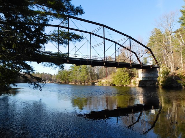
This bridge was one of the only surviving examples of a Pennsylvania truss bridge built by the Berlin Iron Bridge Company. The company was known for lenticular truss bridges, so this bridge is a rare example of the company building other bridge types. Berlin thinking in design details was still apparant in this bridge in the pin connections, which included the company's typical use of cast iron pin caps and cast iron pin spacers inside. The bridge retained excellent historic integrity. It was closed to traffic in 1993.
In 2020 the county chose to demolish this bridge without any replacement. In other words, this highly significant bridge was sent to the scrapyard for no reason. The county claimed they were demolishing the bridge because people were jumping off the bridge and getting killed. However in the same claim they also admitted that natural cliffs in the area also had people jumping off them. So should the county flatten the entire landscape? Historic bridges like this exist all over thr country. Some are abandoned, some are preserved for pedestrian use. Yet they are not being demolished just because someone jumped off of them. There are other, more sensible ways to deal with such a problem. Obviously, since people are jumping off the cliffs, the bridge is not the sole problem. The atrocity of wiping one of the last non-lenticular Berlin Iron Bridge Company bridges in the country is not going to solve anything. All it will do is make the cliffs more popular. The county should not have taken its frustration out on this innocent bridge rather than confronting the greater problem of people performing unsafe activities in the area through more comprehensive means such as policing. Clinton County is home to a number of high and even nationally significant bridges that are closed to traffic. In particular, this poses grave concern for the future of the one-of-a-kind Upper Bridge.
![]()
![]()
![]()
This historic bridge has been demolished. This map is shown for reference purposes only.
Coordinates (Latitude, Longitude):
Search For Additional Bridge Listings:
Bridgehunter.com: View listed bridges within 0.5 miles (0.8 kilometers) of this bridge.
Bridgehunter.com: View listed bridges within 10 miles (16 kilometers) of this bridge.
Additional Maps:
Google Streetview (If Available)
GeoHack (Additional Links and Coordinates)
Apple Maps (Via DuckDuckGo Search)
Apple Maps (Apple devices only)
Android: Open Location In Your Map or GPS App
Flickr Gallery (Find Nearby Photos)
Wikimedia Commons (Find Nearby Photos)
Directions Via Sygic For Android
Directions Via Sygic For iOS and Android Dolphin Browser
USGS National Map (United States Only)
Historical USGS Topo Maps (United States Only)
Historic Aerials (United States Only)
CalTopo Maps (United States Only)

© Copyright 2003-2026, HistoricBridges.org. All Rights Reserved. Disclaimer: HistoricBridges.org is a volunteer group of private citizens. HistoricBridges.org is NOT a government agency, does not represent or work with any governmental agencies, nor is it in any way associated with any government agency or any non-profit organization. While we strive for accuracy in our factual content, HistoricBridges.org offers no guarantee of accuracy. Information is provided "as is" without warranty of any kind, either expressed or implied. Information could include technical inaccuracies or errors of omission. Opinions and commentary are the opinions of the respective HistoricBridges.org member who made them and do not necessarily represent the views of anyone else, including any outside photographers whose images may appear on the page in which the commentary appears. HistoricBridges.org does not bear any responsibility for any consequences resulting from the use of this or any other HistoricBridges.org information. Owners and users of bridges have the responsibility of correctly following all applicable laws, rules, and regulations, regardless of any HistoricBridges.org information.
![]()