We Recommend:
Bach Steel - Experts at historic truss bridge restoration.
BridgeHunter.com Phase 1 is released to the public! - Visit Now
Platt Street Bridge
Pont de Rennes

Primary Photographer(s): Rick McOmber and Marc Scotti
Bridge Documented: October 1, 2010 - July 4, 2020
Rochester: Monroe County, New York: United States
1891 By Builder/Contractor: Rochester Bridge and Iron Works of Rochester, New York and Engineer/Design: Leffert L. Buck
Not Available or Not Applicable
158.2 Feet (48.2 Meters)
858.6 Feet (261.7 Meters)
22 Feet (6.71 Meters)
5 Main Span(s)
2211290

View Information About HSR Ratings
Bridge Documentation
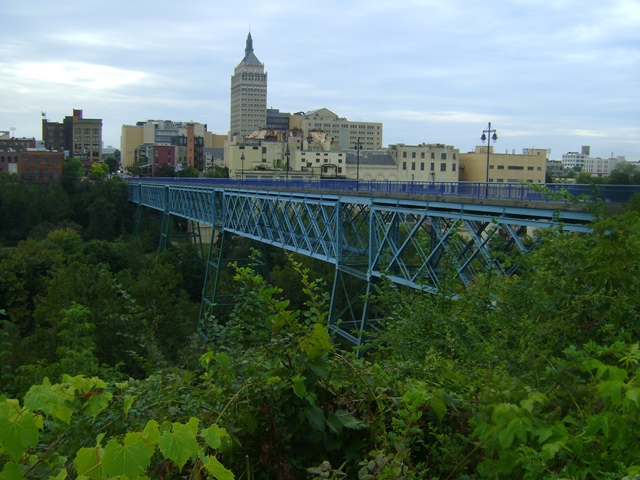
Iconic and preserved for pedestrians, this lattice truss bridge is rare not only as a deck truss variety of this truss configuration, but also for its presentation as a triple intersection Warren. Most lattice trusses in America are quadruple intersection Warrens.
One span of this bridge is slightly shorter at 126.5 feet.
The bridge appears to retain historic integrity although the inventory form shows this bridge once had a beautiful original railing that has been removed and replaced with a modern railing. Given the ample width of this bridge for pedestrian use, there would have been room to retain the original railings behind a pedestrian railing meeting modern code. In the 1990s this bridge was the centerpiece of a popular area of the city, with laser and fireworks shows in the gorge below, all which could be viewed from this bridge which was packed with people during these events. The city later canceled these events to save money, and surrounding businesses declined due to the reduction in foot traffic, so with the loss of tax dollars it is unclear how much the city actually saved with this decision. Today the bridge is more of a through route for pedestrians headed elsewhere.
The French name of this bridge is not because someone got drunk and thought they were on the wrong side of Lake Ontario, the name is due to Rochester's first sister city, Rennes, France. It is interesting to name an American lattice truss bridge to honor a French city, because some of the largest, oldest, and most unique historic bridges in France are lattice truss bridges, some of extremely long length. And while Rennes does not have any of the big examples, they do have a small lattice bridge of their own (technically this would be called a lattice girder) as shown below.
View Historic Bridge Inventory Sheet For This Bridge
View National Register of Historic Places Nomination Form For This Bridge
This bridge is tagged with the following special condition(s): Unorganized Photos
![]()
Photo Galleries and Videos: Platt Street Bridge
Unorganized Photos
Original / Full Size PhotosA collection of overview and detail photos, presented as an unorganized and unlabeled collage and gallery. This gallery offers photos in the highest available resolution and file size in a touch-friendly popup viewer.
Alternatively, Browse Without Using Viewer
![]()
Unorganized Photos
Mobile Optimized PhotosA collection of overview and detail photos, presented as an unorganized and unlabeled collage and gallery. This gallery features data-friendly, fast-loading photos in a touch-friendly popup viewer.
Alternatively, Browse Without Using Viewer
![]()
Maps and Links: Platt Street Bridge
Coordinates (Latitude, Longitude):
Search For Additional Bridge Listings:
Bridgehunter.com: View listed bridges within 0.5 miles (0.8 kilometers) of this bridge.
Bridgehunter.com: View listed bridges within 10 miles (16 kilometers) of this bridge.
Additional Maps:
Google Streetview (If Available)
GeoHack (Additional Links and Coordinates)
Apple Maps (Via DuckDuckGo Search)
Apple Maps (Apple devices only)
Android: Open Location In Your Map or GPS App
Flickr Gallery (Find Nearby Photos)
Wikimedia Commons (Find Nearby Photos)
Directions Via Sygic For Android
Directions Via Sygic For iOS and Android Dolphin Browser
USGS National Map (United States Only)
Historical USGS Topo Maps (United States Only)
Historic Aerials (United States Only)
CalTopo Maps (United States Only)

