We Recommend:
Bach Steel - Experts at historic truss bridge restoration.
BridgeHunter.com Phase 1 is released to the public! - Visit Now
Ouaquaga Bridge
Primary Photographer(s): Nathan Holth
Bridge Documented: May 27, 2007
Ouaquaga: Broome County, New York: United States
1888 By Builder/Contractor: Berlin Iron Bridge Company of East Berlin, Connecticut
1990
170.0 Feet (51.8 Meters)
342.0 Feet (104.2 Meters)
14.8 Feet (4.51 Meters)
2 Main Span(s)
2226050

View Information About HSR Ratings
Bridge Documentation
View Historic American Engineering Record (HAER) Documentation For This Bridge
HAER Drawings, PDF - HAER Data Pages, PDF
View The Original Patent For The Lenticular Truss
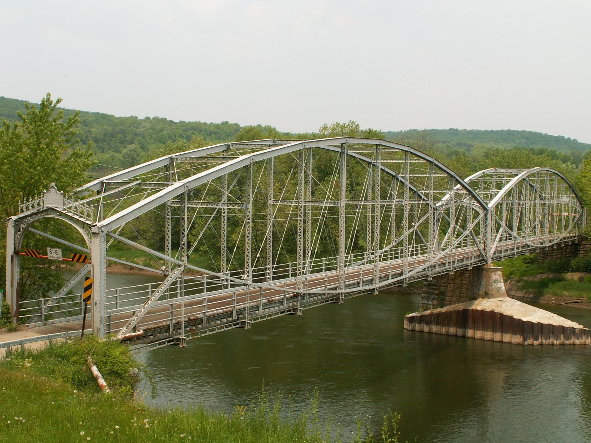
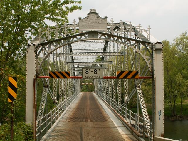
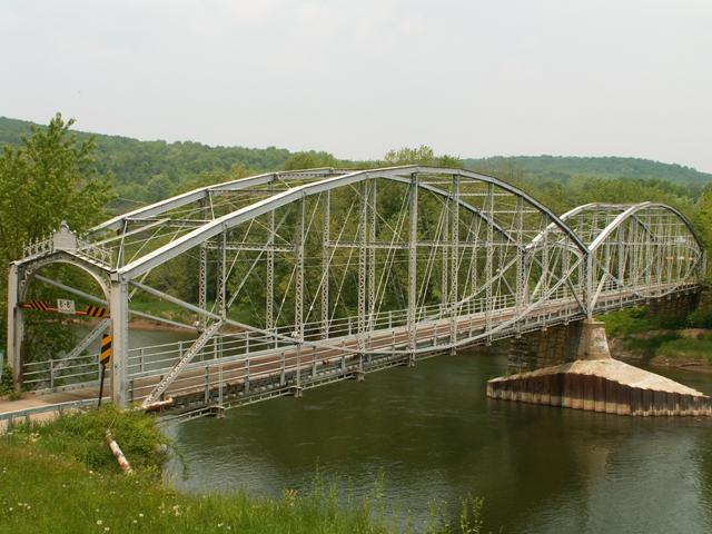
This bridge is perhaps one of the most beautiful bridges in New York State, and one of the best examples of a lenticular truss bridge in the country. While other examples of lenticular truss bridges exist, and some feature longer and more spans, this bridge is special because it is also in a very attractive natural setting. This sets it apart from some of the other larger examples which are often in urban settings. Here, this bridge's complex geometry with the distinctive lens shape, along with the ornate portal bracing decorations are able to stand out, unencumbered by the complexity of an urban setting. Instead, beautiful, large rolling hills and a winding river create a complimentary background. Both bridge and hills are visible from a nicely elevated spot near the bridge, resulting in excellent photos.
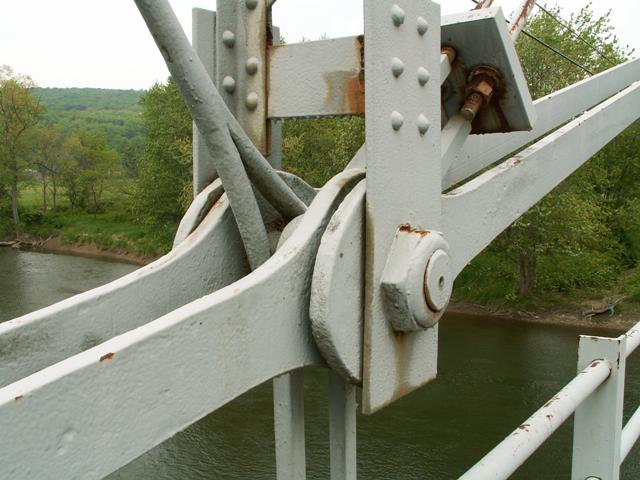
The bridge retains good historic integrity, although some alterations can be found. Most notably, the deck features steel deck stringers and a metal grating deck. The original deck was wooden. In addition, some of the diagonal rods do not appear to be original. The railings are not original either. However the floor beams and the rest of the truss web appears to be largely unaltered. The only easily visible alteration on the bridge is the modern cap placed on the stone pier, however the reason this was placed was quite logical, as the pier was severely damaged during a flood, and this had to be done to keep future floods from washing the bridge away.
Be sure to review the HABS HAER page for technical drawings of the bridge as well as a detailed history.
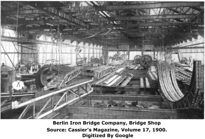
In the historical photo of the Berlin Iron Bridge Company's bridge shop seen on this page note that four portal braces of the same design as that found on this bridge can be seen in the lower right corner of the photo.
Like any surviving lenticular truss bridge, this bridge is nationally significant as an extremely rare and important type of metal truss bridge. The design was known for its graceful and distinctive lens-like shape. The design was one that the Corrugated Metal Company patented and built in various places in the country, from New England to Texas. Today lenticular truss bridges are distinguished as one of the rarest types of bridge in the country. Any remaining example is extremely significant and should be given high priority for preservation.
The Ouaquaga Bridge is particularly significant since it is a multi-span example, with two spans each of notable size. To top that all off, the bridge is an example of a skewed lenticular truss bridge, which only makes it more rare. The skew present on the bridge is 13 degrees. The bridge is skewed to the river itself by 9 degrees and 45 minutes according to HABS HAER's page for the bridge. Certainly the engineers who designed this bridge deserve credit for taking a complex bridge design and skewing it, which would only add to the complexity of the design.
Following the time that HistoricBridges.org documented the bridge, the historic bridge has been bypassed by a modern bridge. The historic bridge was not be demolished however and has been left open for pedestrian use only. Interpretive signage has also been posted. The bypassing of this bridge represents an excellent preservation solution that meets the needs for a safe and efficient vehicular crossing, while also maintaining the historic bridge as an accessible landmark with a good level of historic integrity.

The bypassed bridge as it appears today. Photo Courtesy of Amy L. Osier and Delta Engineers
This bridge is tagged with the following special condition(s): Reused
![]()
Photo Galleries and Videos: Ouaquaga Bridge
Original / Full Size Gallery
Original / Full Size PhotosFor the best visual immersion and full detail, or for use as a desktop background, this gallery presents selected overview and detail photos for this bridge in the original digital camera resolution. This gallery offers photos in the highest available resolution and file size in a touch-friendly popup viewer.
Alternatively, Browse Without Using Viewer
![]()
Structure Overview
Mobile Optimized PhotosA collection of overview photos that show the bridge as a whole and general areas of the bridge. This gallery features data-friendly, fast-loading photos in a touch-friendly popup viewer.
Alternatively, Browse Without Using Viewer
![]()
Structure Details
Mobile Optimized PhotosA collection of detail photos that document the parts, construction, and condition of the bridge. This gallery features data-friendly, fast-loading photos in a touch-friendly popup viewer.
Alternatively, Browse Without Using Viewer
![]()
Maps and Links: Ouaquaga Bridge
Coordinates (Latitude, Longitude):
Search For Additional Bridge Listings:
Bridgehunter.com: View listed bridges within 0.5 miles (0.8 kilometers) of this bridge.
Bridgehunter.com: View listed bridges within 10 miles (16 kilometers) of this bridge.
Additional Maps:
Google Streetview (If Available)
GeoHack (Additional Links and Coordinates)
Apple Maps (Via DuckDuckGo Search)
Apple Maps (Apple devices only)
Android: Open Location In Your Map or GPS App
Flickr Gallery (Find Nearby Photos)
Wikimedia Commons (Find Nearby Photos)
Directions Via Sygic For Android
Directions Via Sygic For iOS and Android Dolphin Browser
USGS National Map (United States Only)
Historical USGS Topo Maps (United States Only)
Historic Aerials (United States Only)
CalTopo Maps (United States Only)


