

View Information About HSR Ratings
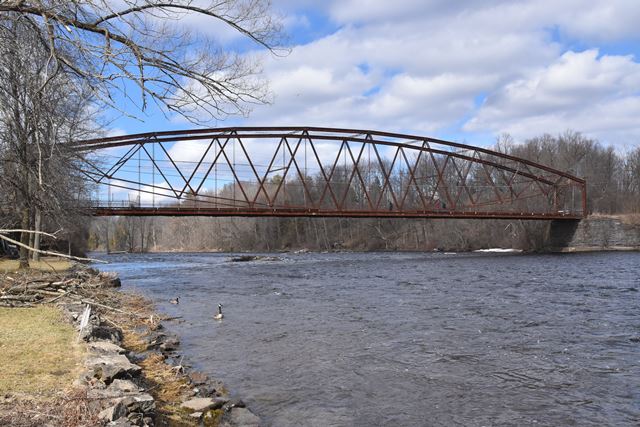
Along with the Jersey Shore Bridge in Pennsylvania, this is one of the two longest spanning Berlin Iron Bridge Company lenticular truss bridges in the country. The Berlin Iron Bridge Company chose a Warren truss layout of the diagonal members for these two long-spanning bridges, rather than the typical Pratt style layout usually found on its lenticular truss bridges.
As one of the largest examples of this rare type in the country and also with some details that differ from the typical Berlin Iron Bridge Company lenticular truss bridge, this bridge has national significance.
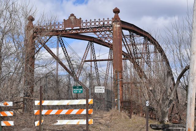
Although abandoned, this bridge retains good historic integrity overall, although it has one thing in common with the Pennsylvania bridge in that the unique riveted bottom chord appears to be a replacement of the original. The alteration of this New York example is much older however, having taken place in 1930-1932. The floor beams, bottom chord, lower lateral bracing, and deck stringers all appear to have been replaced at this time. Because rivets were still in use at this time, some of the fasteners on the lower lateral bracing are riveted. The 1930 lower lateral bracing, attached with riveted gusset plates, was a more rigid design than the original bracing which was likely a eyebar/rod-based design. The only other alteration of note is the loss of the original railing, with a piece of the original railing apparently used to barricade the bridge when it was closed.
![]()
![]()
![]()
Coordinates (Latitude, Longitude):
Search For Additional Bridge Listings:
Bridgehunter.com: View listed bridges within 0.5 miles (0.8 kilometers) of this bridge.
Bridgehunter.com: View listed bridges within 10 miles (16 kilometers) of this bridge.
Additional Maps:
Google Streetview (If Available)
GeoHack (Additional Links and Coordinates)
Apple Maps (Via DuckDuckGo Search)
Apple Maps (Apple devices only)
Android: Open Location In Your Map or GPS App
Flickr Gallery (Find Nearby Photos)
Wikimedia Commons (Find Nearby Photos)
Directions Via Sygic For Android
Directions Via Sygic For iOS and Android Dolphin Browser
USGS National Map (United States Only)
Historical USGS Topo Maps (United States Only)
Historic Aerials (United States Only)
CalTopo Maps (United States Only)

© Copyright 2003-2026, HistoricBridges.org. All Rights Reserved. Disclaimer: HistoricBridges.org is a volunteer group of private citizens. HistoricBridges.org is NOT a government agency, does not represent or work with any governmental agencies, nor is it in any way associated with any government agency or any non-profit organization. While we strive for accuracy in our factual content, HistoricBridges.org offers no guarantee of accuracy. Information is provided "as is" without warranty of any kind, either expressed or implied. Information could include technical inaccuracies or errors of omission. Opinions and commentary are the opinions of the respective HistoricBridges.org member who made them and do not necessarily represent the views of anyone else, including any outside photographers whose images may appear on the page in which the commentary appears. HistoricBridges.org does not bear any responsibility for any consequences resulting from the use of this or any other HistoricBridges.org information. Owners and users of bridges have the responsibility of correctly following all applicable laws, rules, and regulations, regardless of any HistoricBridges.org information.
![]()