

View Information About HSR Ratings
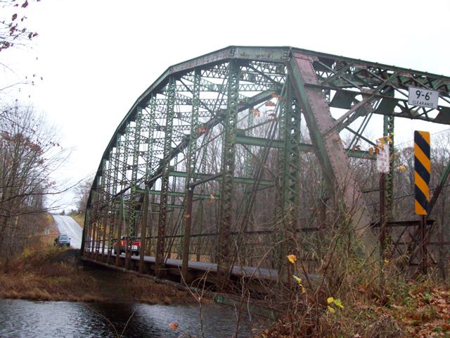
Oswego County decided the best way to address this beautiful and very rare pin-connected Pennsylvania through truss was to reduce it to scrap metal. This bridge could have and should have been preserved, even if relocated to a trail or park. The Pennsylvania truss configuration is one of the most visually fascinating truss configurations due to its complexity. It would have been a signature landmark attraction in any park or on any trail system. Very few opportunities to preserve bridges of this type remain making it disappointing that this opportunity was cast aside.
The National Bridge Inventory gave a 1940 construction date for this bridge which is totally inaccurate as this bridge type had not been built for decades. The date may be an error, or may indicate a relocation of this bridge from an unknown previous location at that time. A photo submitted to HistoricBridges.org had a note that the bridge dated to ca. 1920. Although still pretty late for this bridge type, this date is feasible and likely closer to accurate.
This bridge is tagged with the following special condition(s): Unorganized Photos
![]()
![]()
![]()
This historic bridge has been demolished. This map is shown for reference purposes only.
Coordinates (Latitude, Longitude):
Search For Additional Bridge Listings:
Bridgehunter.com: View listed bridges within 0.5 miles (0.8 kilometers) of this bridge.
Bridgehunter.com: View listed bridges within 10 miles (16 kilometers) of this bridge.
Additional Maps:
Google Streetview (If Available)
GeoHack (Additional Links and Coordinates)
Apple Maps (Via DuckDuckGo Search)
Apple Maps (Apple devices only)
Android: Open Location In Your Map or GPS App
Flickr Gallery (Find Nearby Photos)
Wikimedia Commons (Find Nearby Photos)
Directions Via Sygic For Android
Directions Via Sygic For iOS and Android Dolphin Browser
USGS National Map (United States Only)
Historical USGS Topo Maps (United States Only)
Historic Aerials (United States Only)
CalTopo Maps (United States Only)

© Copyright 2003-2026, HistoricBridges.org. All Rights Reserved. Disclaimer: HistoricBridges.org is a volunteer group of private citizens. HistoricBridges.org is NOT a government agency, does not represent or work with any governmental agencies, nor is it in any way associated with any government agency or any non-profit organization. While we strive for accuracy in our factual content, HistoricBridges.org offers no guarantee of accuracy. Information is provided "as is" without warranty of any kind, either expressed or implied. Information could include technical inaccuracies or errors of omission. Opinions and commentary are the opinions of the respective HistoricBridges.org member who made them and do not necessarily represent the views of anyone else, including any outside photographers whose images may appear on the page in which the commentary appears. HistoricBridges.org does not bear any responsibility for any consequences resulting from the use of this or any other HistoricBridges.org information. Owners and users of bridges have the responsibility of correctly following all applicable laws, rules, and regulations, regardless of any HistoricBridges.org information.
![]()