We Recommend:
Bach Steel - Experts at historic truss bridge restoration.
BridgeHunter.com Phase 1 is released to the public! - Visit Now
Schoellkopf Road Bridge
Wyoming County Fairgrounds Bridge

Primary Photographer(s): Marc Scotti
Bridge Documented: April 9, 2022
Pike: Wyoming County, New York: United States
1905 By Builder/Contractor: Owego Bridge Company of Owego, New York
Not Available or Not Applicable
101.0 Feet (30.8 Meters)
103.0 Feet (31.4 Meters)
14.4 Feet (4.39 Meters)
1 Main Span(s)
3370600

View Information About HSR Ratings
Bridge Documentation
View This Relocated Historic Bridge's Page In Its Previous Schoellkopf Road Location Here
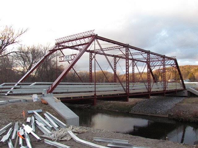
This Pratt truss bridge is noted for its ornate portal cresting and was spared demolition and moved here to the Wyoming County Fairgrounds in 2022. This was not the first time it had moved. According to Phil Palen, Gowanda Area Historical Society, this span originally was the State Hospital Bridge in Collins, Erie County. It spanned the south branch of Clear Creek on what is now US 62/NY-39, just north of Collins Correctional Facility (42.494424, -78.92863). It was moved to Schoellkopf Road in 1933. The relocation and reuse of this bridge is a positive development and its location should ensure relatively light use and a long service life. The relocation contractor was L. C. Whitford of Wellsville.
An unusual aspect of the relocation is that the entire top chord and endpost appears to have been replaced. It is unclear why such an extensive replacement was done. Alternative repair approaches do exist to limit wholesale replacement of historic truss bridge members. Bolts were used instead of rivets, so the alterations are clear to anyone visiting the bridge. Also, the lower laterals were connected to the abutments instead of the end floor beams, which may have been eliminated, another unusual repair approach.
Another unusual aspect of this project is that this through truss also displaced another historic bridge, a pony truss at this location. For now however, that pony truss has also been spared demolition and is stored (fully assembled) on the ground nearby in a manner conducive to something other than being scrapped out as its supported and kept off the dirt.
The National Bridge Inventory listed a span length of 98.8 but other sources indicate a 101 foot span. A ca. 1905 construction date was given. Historical photos confirmed the builder for this bridge, please see the other page for that.
View Historic Bridge Inventory Sheet For This Bridge
This bridge is tagged with the following special condition(s): Unorganized Photos
![]()
Photo Galleries and Videos: Schoellkopf Road Bridge
Unorganized Photos
Original / Full Size PhotosA collection of overview and detail photos, presented as an unorganized and unlabeled collage and gallery. This gallery offers photos in the highest available resolution and file size in a touch-friendly popup viewer.
Alternatively, Browse Without Using Viewer
![]()
Unorganized Photos
Mobile Optimized PhotosA collection of overview and detail photos, presented as an unorganized and unlabeled collage and gallery. This gallery features data-friendly, fast-loading photos in a touch-friendly popup viewer.
Alternatively, Browse Without Using Viewer
![]()
Maps and Links: Schoellkopf Road Bridge
Coordinates (Latitude, Longitude):
Search For Additional Bridge Listings:
Bridgehunter.com: View listed bridges within 0.5 miles (0.8 kilometers) of this bridge.
Bridgehunter.com: View listed bridges within 10 miles (16 kilometers) of this bridge.
Additional Maps:
Google Streetview (If Available)
GeoHack (Additional Links and Coordinates)
Apple Maps (Via DuckDuckGo Search)
Apple Maps (Apple devices only)
Android: Open Location In Your Map or GPS App
Flickr Gallery (Find Nearby Photos)
Wikimedia Commons (Find Nearby Photos)
Directions Via Sygic For Android
Directions Via Sygic For iOS and Android Dolphin Browser
USGS National Map (United States Only)
Historical USGS Topo Maps (United States Only)
Historic Aerials (United States Only)
CalTopo Maps (United States Only)

