We Recommend:
Bach Steel - Experts at historic truss bridge restoration.
BridgeHunter.com Phase 1 is released to the public! - Visit Now
Thousand Islands Bridge
South Channel (American) Bridge

Primary Photographer(s): Nathan Holth and Rick McOmber
Bridge Documented: July 20, 2013 and April 8, 2018
I-81 Over St. Lawrence River (Fleuve Saint-Laurent) South Channel
Rural: Jefferson County, New York: United States
Metal Plate Girder Stiffening Wire Cable Suspension, Fixed and Approach Spans: Metal Deck Girder, Fixed
1937 By Builder/Contractor: American Bridge Company of New York, New York and Engineer/Design: Robinson and Steinman of New York, New York
2000
800.0 Feet (243.8 Meters)
4,500.0 Feet (1371.6 Meters)
24 Feet (7.32 Meters)
3 Main Span(s) and 42 Approach Span(s)
5523240

View Information About HSR Ratings
Bridge Documentation
This bridge's future is at risk!
Bridge Status: This historic bridge is at risk for demolition and replacement!View Archived National Bridge Inventory Report - Has Additional Details and Evaluation
View Historical Article About This Bridge
Visit The Thousand Islands Bridge Authority Website
View A Report On The Future of the Thousand Islands Bridges
The Thousand Islands Bridge is actually three distinct bridges that hop across islands in the St. Lawrence River. The bridges include the U.S. Bridge, the International Rift Bridge, and the Canadian Bridge. The three bridges are often referred to as a single bridge, but from an engineering standpoint they are clearly three bridges, and as such are represented by separate pages on HistoricBridges.org.
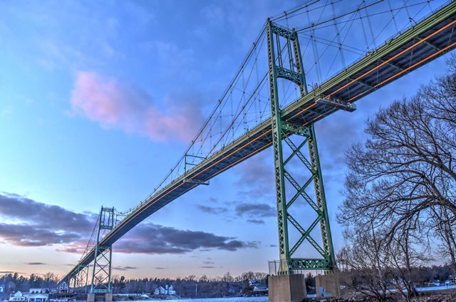
The American Bridge features less span variety than the Canadian Bridge, but features a suspension span that is slightly longer than the Canadian Bridge's largest suspension span. Also, the American Bridge has a longer approach system, which brings the bridge up to the height needed for freighters to pass under it. The approach system consists of a series of deck plate girder spans.
The bridge's suspension spans are a classic David Steinman suspension bridge. They feature his unique Vierendeel truss towers. Vierendeel refers to the concept of forming a truss using verticals only without diagonal members, and this is visible in a portion of the tower bracing design. Steinman used this design on several bridges he designed. The bridge also features the sleek, shallow plate girder stiffening that is very similar to the Deer Isle Bridge in Maine. Both of these bridges were built in the years leading up to the infamous collapse of the Tacoma Narrows Bridge in Washington in 1940. During these years, engineers, including David Steinman theorized that suspension bridges did not need as much stiffening as had been used in earlier suspension bridges. In some cases, this meant using something more lightweight than a traditional heavy stiffening truss. Instead, Steinman used a shallow plate girder stiffening. When the Tacoma Narrows Bridge collapsed, engineers quickly learned that their theory was incorrect, and that substantial stiffening was needed, bringing an end to the period of minimal stiffening. In response, for the Deer Isle and Thousand Islands Bridge, Steinman's firm was rehired by their owners to retrofit the bridges and protect them from collapse. For both bridges, Steinman's firm designated the addition of cable stays and braces to be added in addition to the suspension system. These cables and bars run from the main cable to the stiffening girder in various places on the bridge. The bridge includes a traditional Steinman detail of a cable bent, where near the ends of the suspension structure, when the main cable is at the deck level, a saddle redirects the cable downward into the anchorage. The central span of the suspension structure is 800 feet (240 meters). The side suspension spans are 350 feet (106.7 meters)
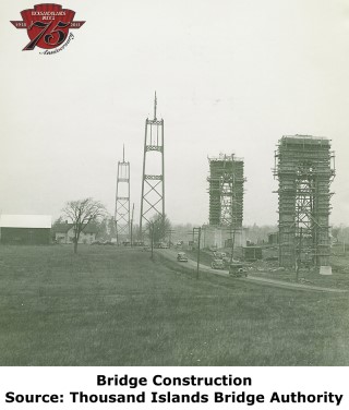
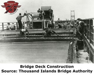
The Thousand Islands Bridge celebrated its 75th Anniversary in 2013, and a number of historical photos were released as part of the events by the Thousand Island Bridge Authority. Some of those photos appear on this page.
The future of the Thousand Island Bridges is uncertain. A report released about the bridges recommends the demolition and replacement of the United States bridge in the near term, but leaves the future of the Canadian Bridge uncertain. The report seems to suggest that demolition and replacement of the Canadian span eventually would be preferable to building a second bridge to form a one-way couplet. However, the report is ignorant of the historic significance of these bridges and their impact to an area that is defined by its tourism and beauty. The value of these bridges as such extends far beyond their function. If additional capacity is needed, a one-way couplet solution is the best solution for both bridges.
![]()
Photo Galleries and Videos: Thousand Islands Bridge
Bridge Photo-Documentation
Original / Full Size PhotosA collection of overview and detail photos. This gallery offers photos in the highest available resolution and file size in a touch-friendly popup viewer.
Alternatively, Browse Without Using Viewer
![]()
Bridge Photo-Documentation
Mobile Optimized PhotosA collection of overview and detail photos. This gallery features data-friendly, fast-loading photos in a touch-friendly popup viewer.
Alternatively, Browse Without Using Viewer
![]()
Maps and Links: Thousand Islands Bridge
Coordinates (Latitude, Longitude):
Search For Additional Bridge Listings:
Bridgehunter.com: View listed bridges within 0.5 miles (0.8 kilometers) of this bridge.
Bridgehunter.com: View listed bridges within 10 miles (16 kilometers) of this bridge.
Additional Maps:
Google Streetview (If Available)
GeoHack (Additional Links and Coordinates)
Apple Maps (Via DuckDuckGo Search)
Apple Maps (Apple devices only)
Android: Open Location In Your Map or GPS App
Flickr Gallery (Find Nearby Photos)
Wikimedia Commons (Find Nearby Photos)
Directions Via Sygic For Android
Directions Via Sygic For iOS and Android Dolphin Browser
USGS National Map (United States Only)
Historical USGS Topo Maps (United States Only)
Historic Aerials (United States Only)
CalTopo Maps (United States Only)


