

View Information About HSR Ratings

This incredible bridge is the oldest of the three metal arch bridges in this section of the Harlem River, and it is also the only one with two main metal arch spans. One metal arch span crosses the river and the other crosses land. The two spans were referred to simply as the "land span" and the "river span." The bridge features attractive stone arch approach spans as well.
The most visually pleasing and striking feature of this bridge is the grid of verticals and bracing that is present between the deck and the arch ring of this bridge. All of these members are built-up beams with v-lacing so from a distance they appear identical. In addition, this grid pattern is repeated in each arch rib, parallel to each other. There are six ribs and thus six repetitions of this grid pattern in total, and they combine to form a dazzling appearance that is unlike any other bridge.
Additional aesthetic treatment on the bridge is present at the deck level in the form of extremely ornate railings and other matching decoration at the deck line.
More information is available here.


Above: Early 20th Century Photo of Bridge. Source: Library of Congress
The design and construction of this bridge was extensively documented in books and engineering texts of the period. One book, which is linked to at the top of this page, contains numerous drawings and photos. Some of the photos and drawings worth particular note are shown below. Also available below are improved versions of some of the drawings that are difficult to look at in the PDF book because they spread over two pages. The below images may be clicked on to load a high-resolution version of the image. The source for all the below photos is: Hutton, William R., The Washington Bridge Over The Harlem River, At 181st Street, New York City, 1889. Digitized By Google.

Above: General views of bridge construction. Note the enormous amounts of falsework, called "centers" or "centering" that was required to construct both the steel and stone arch spans.
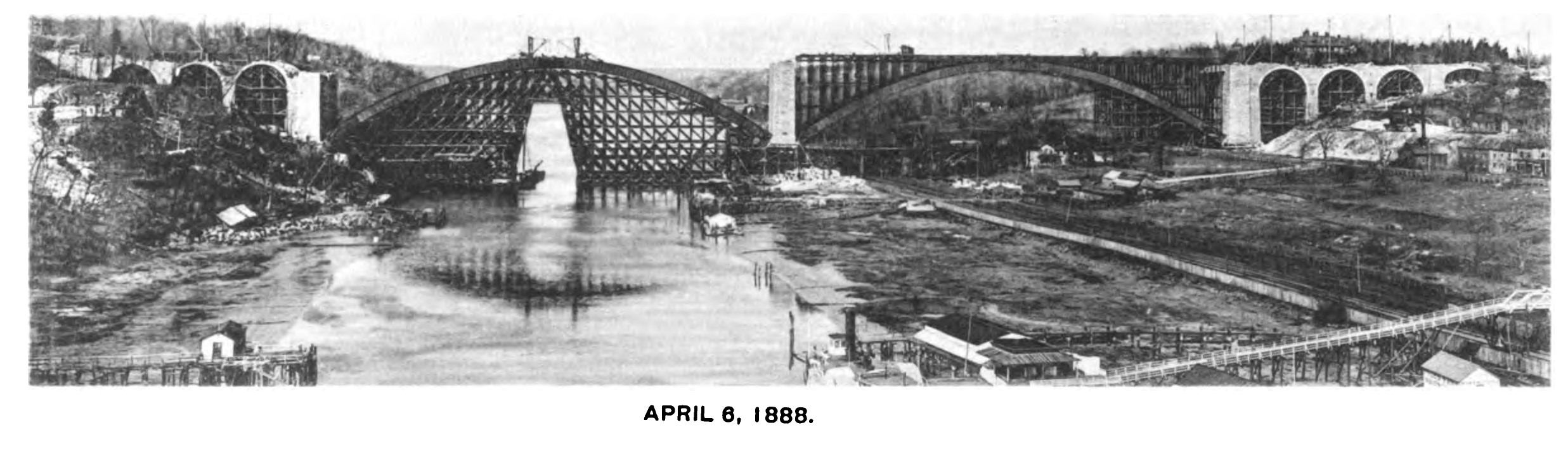
Above: This photo shows the opening that was required in the centering for the river span to allow

Above: This photo shows one of the metal arch segments being lifted into place.
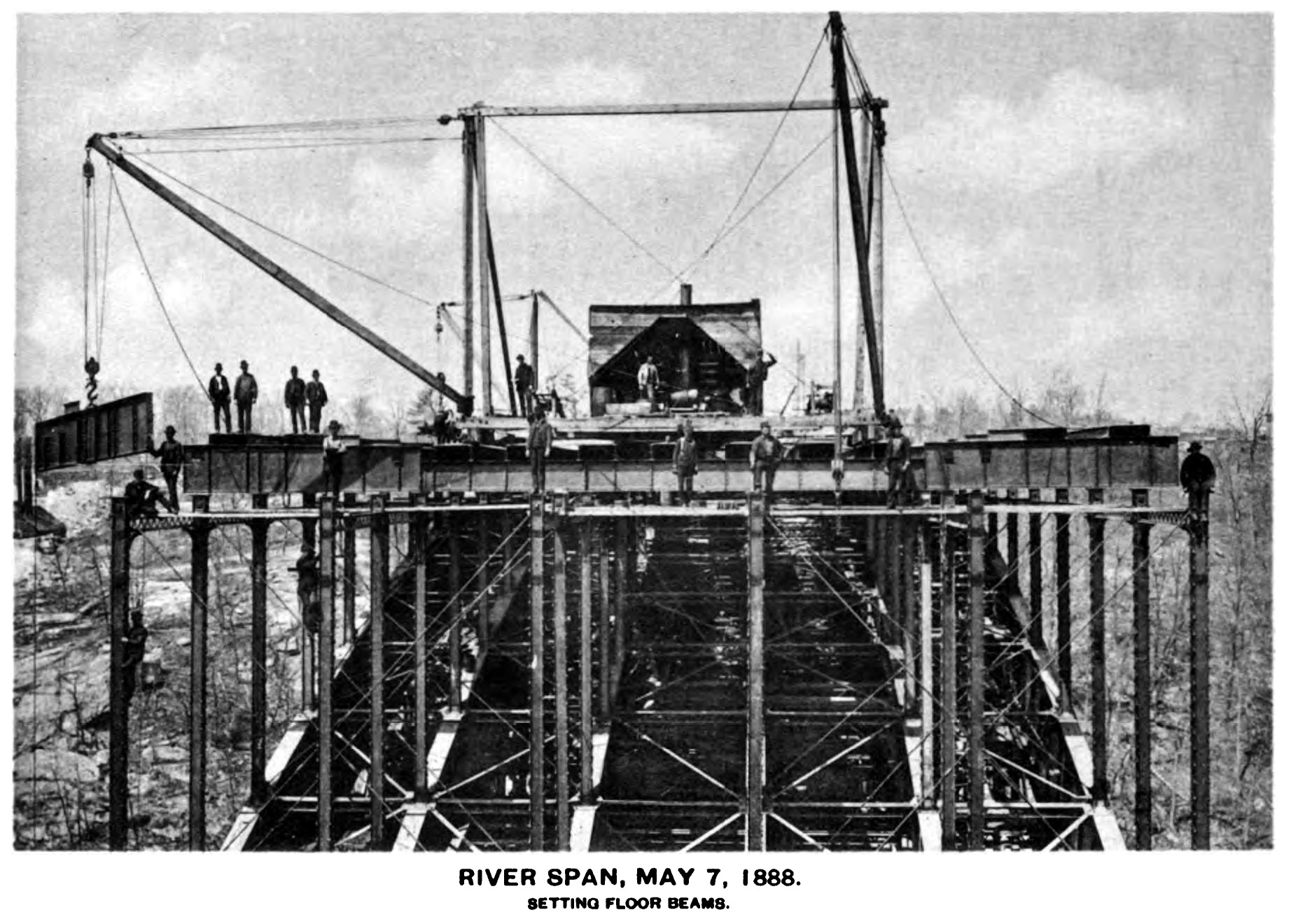
Above: This photo show the floorbeams being placed on the bridge.

Above: This bridge was built in 1888 and its design required field riveting, something not popular in the United States until the hand-held Boyer style rivet hammers came around in the early 1900s. This photo shows workers using the large riveter required in the pre-handheld era.

Above: Drawing showing an overview of the construction process.


Above: Drawings for construction equipment used for building the bridge.

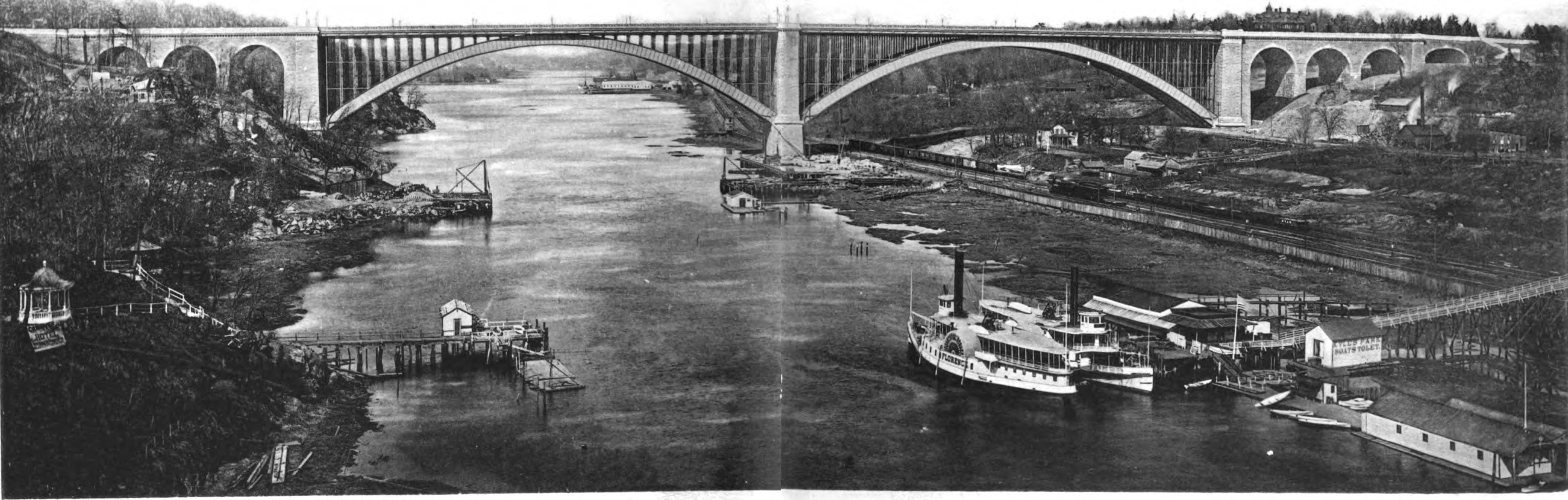
Above: Views of the newly completed bridge.


Above: To the left a photo, and to the right a drawing, of the extremely ornate railings for the metal arch spans.
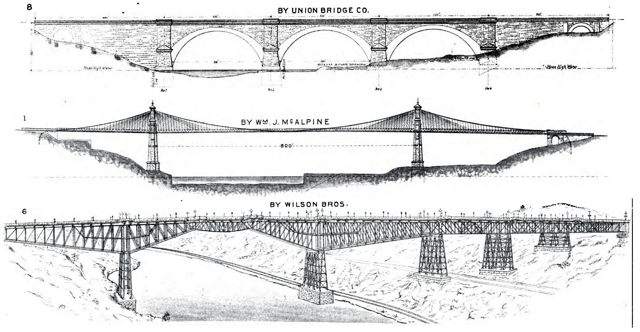
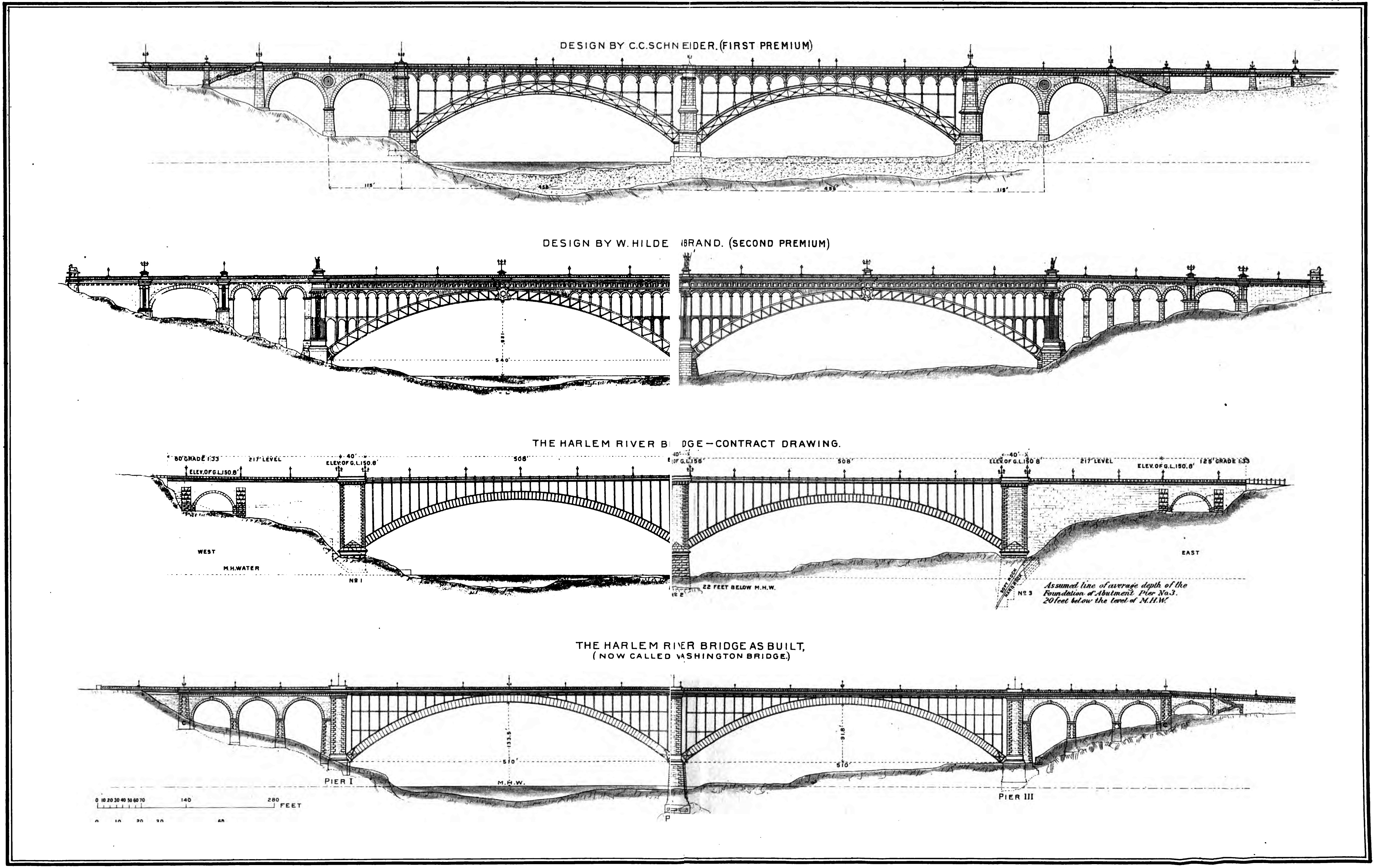
Above: Numerous proposals were received for the design of this bridge. The drawings as left showcase some of the proposals that were not a metal arch, and the drawings on the right show metal arch proposals including the as-built bridge.

Above: Drawing of the bearing, also called the pedestal in some texts.
![]()
![]()
![]()
Coordinates (Latitude, Longitude):
Search For Additional Bridge Listings:
Bridgehunter.com: View listed bridges within 0.5 miles (0.8 kilometers) of this bridge.
Bridgehunter.com: View listed bridges within 10 miles (16 kilometers) of this bridge.
Additional Maps:
Google Streetview (If Available)
GeoHack (Additional Links and Coordinates)
Apple Maps (Via DuckDuckGo Search)
Apple Maps (Apple devices only)
Android: Open Location In Your Map or GPS App
Flickr Gallery (Find Nearby Photos)
Wikimedia Commons (Find Nearby Photos)
Directions Via Sygic For Android
Directions Via Sygic For iOS and Android Dolphin Browser
USGS National Map (United States Only)
Historical USGS Topo Maps (United States Only)
Historic Aerials (United States Only)
CalTopo Maps (United States Only)

© Copyright 2003-2026, HistoricBridges.org. All Rights Reserved. Disclaimer: HistoricBridges.org is a volunteer group of private citizens. HistoricBridges.org is NOT a government agency, does not represent or work with any governmental agencies, nor is it in any way associated with any government agency or any non-profit organization. While we strive for accuracy in our factual content, HistoricBridges.org offers no guarantee of accuracy. Information is provided "as is" without warranty of any kind, either expressed or implied. Information could include technical inaccuracies or errors of omission. Opinions and commentary are the opinions of the respective HistoricBridges.org member who made them and do not necessarily represent the views of anyone else, including any outside photographers whose images may appear on the page in which the commentary appears. HistoricBridges.org does not bear any responsibility for any consequences resulting from the use of this or any other HistoricBridges.org information. Owners and users of bridges have the responsibility of correctly following all applicable laws, rules, and regulations, regardless of any HistoricBridges.org information.
![]()