We Recommend:
Bach Steel - Experts at historic truss bridge restoration.
BridgeHunter.com Phase 1 is released to the public! - Visit Now
Worden Road Bridge

Primary Photographer(s): Marc Scotti
Bridge Documented: July 10, 2010 and September 2, 2013
Rural: Jefferson County, New York: United States
1910 By Builder/Contractor: F. W. Sage of Rochester, New York
1942
68.0 Feet (20.7 Meters)
130.0 Feet (39.6 Meters)
11.2 Feet (3.41 Meters)
2 Main Span(s)
3338790

View Information About HSR Ratings
Bridge Documentation
View Archived National Bridge Inventory Report - Has Additional Details and Evaluation
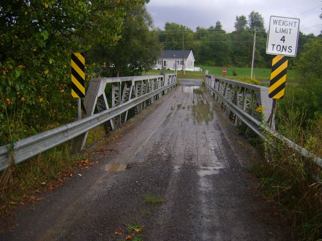
At quick glance, the two spans of this bridge might seem identical. However, look closely, and one span has slightly deeper trusses (and only four panels instead of five) and some slight differences in the composition of its truss members. The reason for these differences are unknown. The bridge sits on a substructure that was reconstructed in 1942. The bridge has lost its original railings, and some welded repairs were noted, but otherwise the trusses retain integrity of design.
In 2010, the posted weight limit for the bridge was 12 tons, and three years later it had dropped to 4 tons. Weight limits should never be used to determine the condition of a bridge. In some cases, bridges are posted for less weight than they can handle, due either to a desire to prolong the life of the bridge, or sometimes it is due to a lack of understanding about the particular design of the bridge. In other cases, a low weight limit might indicate deterioration, but how much and how extensive cannot be told from a weight limit. For example, if one tiny but important part of the bridge is deteriorated, that might be an easy fix, but until its fixed that little "controlling" element drags the whole bridge weight limit down. It is not known what the case is with this bridge. While the bridge is likely at risk for demolition and replacement, it could very well be feasible to rehabilitate to, an option that should be given priority given that this is a historic bridge.
![]()
Photo Galleries and Videos: Worden Road Bridge
Bridge Photo-Documentation
Original / Full Size PhotosA collection of overview and detail photos. This gallery offers photos in the highest available resolution and file size in a touch-friendly popup viewer.
Alternatively, Browse Without Using Viewer
![]()
Bridge Photo-Documentation
Mobile Optimized PhotosA collection of overview and detail photos. This gallery features data-friendly, fast-loading photos in a touch-friendly popup viewer.
Alternatively, Browse Without Using Viewer
![]()
Maps and Links: Worden Road Bridge
Coordinates (Latitude, Longitude):
Search For Additional Bridge Listings:
Bridgehunter.com: View listed bridges within 0.5 miles (0.8 kilometers) of this bridge.
Bridgehunter.com: View listed bridges within 10 miles (16 kilometers) of this bridge.
Additional Maps:
Google Streetview (If Available)
GeoHack (Additional Links and Coordinates)
Apple Maps (Via DuckDuckGo Search)
Apple Maps (Apple devices only)
Android: Open Location In Your Map or GPS App
Flickr Gallery (Find Nearby Photos)
Wikimedia Commons (Find Nearby Photos)
Directions Via Sygic For Android
Directions Via Sygic For iOS and Android Dolphin Browser
USGS National Map (United States Only)
Historical USGS Topo Maps (United States Only)
Historic Aerials (United States Only)
CalTopo Maps (United States Only)

