


View Information About HSR Ratings
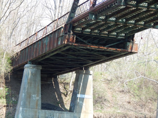
This bridge is one of the most unusual bridges in the country. It consists of a standard New York State Erie/Barge Canal through truss span of about 148-150 feet, however the northeast end of the truss span does not bear on a pier, instead it bears on a plate girder span that is cantilevered out from a pier. As such, this bridge is a cantilever bridge. It is difficult to classify. Main spans of cantilever bridges are typically measured from pier to pier, although the National Bridge Inventory listing counted the length of the truss from bearing to bearing as a main span length. The span between pier points which includes all of the truss and the cantilever arm is estimated at 200 feet, which is what HistoricBridges.org is listing as the main span length. Most of this span is a truss bridge, so the main span type was listed as a through truss with eight panels, but technically the main span is partially a plate girder. The panels of the plate girder were not included in the main span panel count. The combination of span types to make a cantilever bridge is extremely unusual. Also unusual is the fact that only the northeast end of the bridge is a cantilever design. The other end of the truss span simply bears on a pier. As a cantilevered structure, the plate girder span has an anchor arm span, featuring an abutment bearing which is technically an anchorage and is composed of tension eyebars embedded in concrete at the abutment.
The plate girder structure is also unusual because it consists of a pair of girders on either side of the roadway, not just a single girder as is typical.
This bridge is abandoned. Some of the approach spans southwest of the truss span have been removed. However the truss span and the cantilever plate girder retain excellent historic integrity.
The bridge originally had a Warren pony truss approach span at the southern end which has been removed in recent years (well into the 2000s). The northern end is missing approach spans which may have been concrete slabs, as seen on other similar bridges in the state. The bridge was originally configured as a traditional simple span through truss with concrete piers, but the plate girder cantilever alteration was added when the canal was widened in 1948, which resulted in the removal of one of the concrete piers for the through truss. Regardless, the cantilevered plate girder is riveted and even as an alteration, it is a remarkable example of bridge engineering and the bridge including the cantilever system should be considered Eligible for Listing in the National Register of Historic Places under Criterion C, for its engineering design. The bridge is highly significant.
Included at the end of the photo gallery are shots of depression-era cable guard rails and a short section of one of the earlier generations of the Erie Canal.
Above: Detail showing the plate girder cantilever arm, and the truss bearing. Also note that the plate girder structure consists of a pair of girders on either side of the roadway, not just a single girder as is typical.
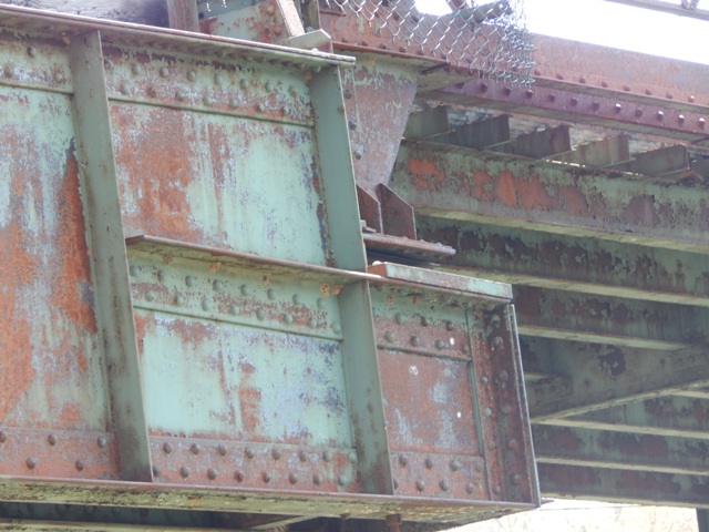
Above: Detail of truss span bearing on plate girder span.

Above: These two older photos by Joel Wyman are the only known photos that show the pony truss that used to exist here as an approach span.
![]()
![]()
![]()
Coordinates (Latitude, Longitude):
Search For Additional Bridge Listings:
Bridgehunter.com: View listed bridges within 0.5 miles (0.8 kilometers) of this bridge.
Bridgehunter.com: View listed bridges within 10 miles (16 kilometers) of this bridge.
Additional Maps:
Google Streetview (If Available)
GeoHack (Additional Links and Coordinates)
Apple Maps (Via DuckDuckGo Search)
Apple Maps (Apple devices only)
Android: Open Location In Your Map or GPS App
Flickr Gallery (Find Nearby Photos)
Wikimedia Commons (Find Nearby Photos)
Directions Via Sygic For Android
Directions Via Sygic For iOS and Android Dolphin Browser
USGS National Map (United States Only)
Historical USGS Topo Maps (United States Only)
Historic Aerials (United States Only)
CalTopo Maps (United States Only)

© Copyright 2003-2025, HistoricBridges.org. All Rights Reserved. Disclaimer: HistoricBridges.org is a volunteer group of private citizens. HistoricBridges.org is NOT a government agency, does not represent or work with any governmental agencies, nor is it in any way associated with any government agency or any non-profit organization. While we strive for accuracy in our factual content, HistoricBridges.org offers no guarantee of accuracy. Information is provided "as is" without warranty of any kind, either expressed or implied. Information could include technical inaccuracies or errors of omission. Opinions and commentary are the opinions of the respective HistoricBridges.org member who made them and do not necessarily represent the views of anyone else, including any outside photographers whose images may appear on the page in which the commentary appears. HistoricBridges.org does not bear any responsibility for any consequences resulting from the use of this or any other HistoricBridges.org information. Owners and users of bridges have the responsibility of correctly following all applicable laws, rules, and regulations, regardless of any HistoricBridges.org information.
![]()