

View Information About HSR Ratings
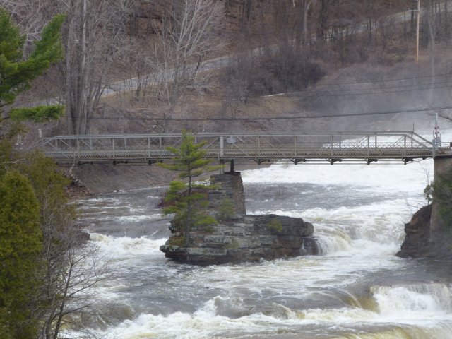
This bridge is a very rare example of a multi-span pin-connected pony truss that is continuous in design. Non-cantilever pin-connected truss bridges are exceedingly rare nationwide. The continuous design of this bridge is evident in the unusual design of the truss at the pier, where a large vertical post is located which has two pin connections. This post is where two separate end posts would be if simple truss spans were present. The center "end" post for this continuous bridge has another unusual feature in that it extends below the bottom chord like a bedstead truss, resting on the pier below. The pier itself is unusual since it is built right into a natural outcropping of rock. The overall surrounding setting is one of the most picturesque to be encountered as a waterfall is located immediately downstream. The waterfall and pony truss can be viewed from the nearby US-9 Bridge. This bridge has been closed to vehicular traffic, but the bridge retains good historic integrity. The bridge would be an excellent candidate for restoration for non-motorized use only in its existing location. The builder of this bridge is unknown, but it may be the product of the Groton Bridge and Manufacturing Company, prolific in the state, however there are not enough distinctive details to substantiate that suspicion. The National Register of Historic Places Multiple Property Submission that includes this bridge suggests a ca. 1890 construction date for the bridge.

Above: Historical photo showing bridge construction ca. 1890. Photo Credit: Sara Perkett. The man on the far left is Pascal Perkett.
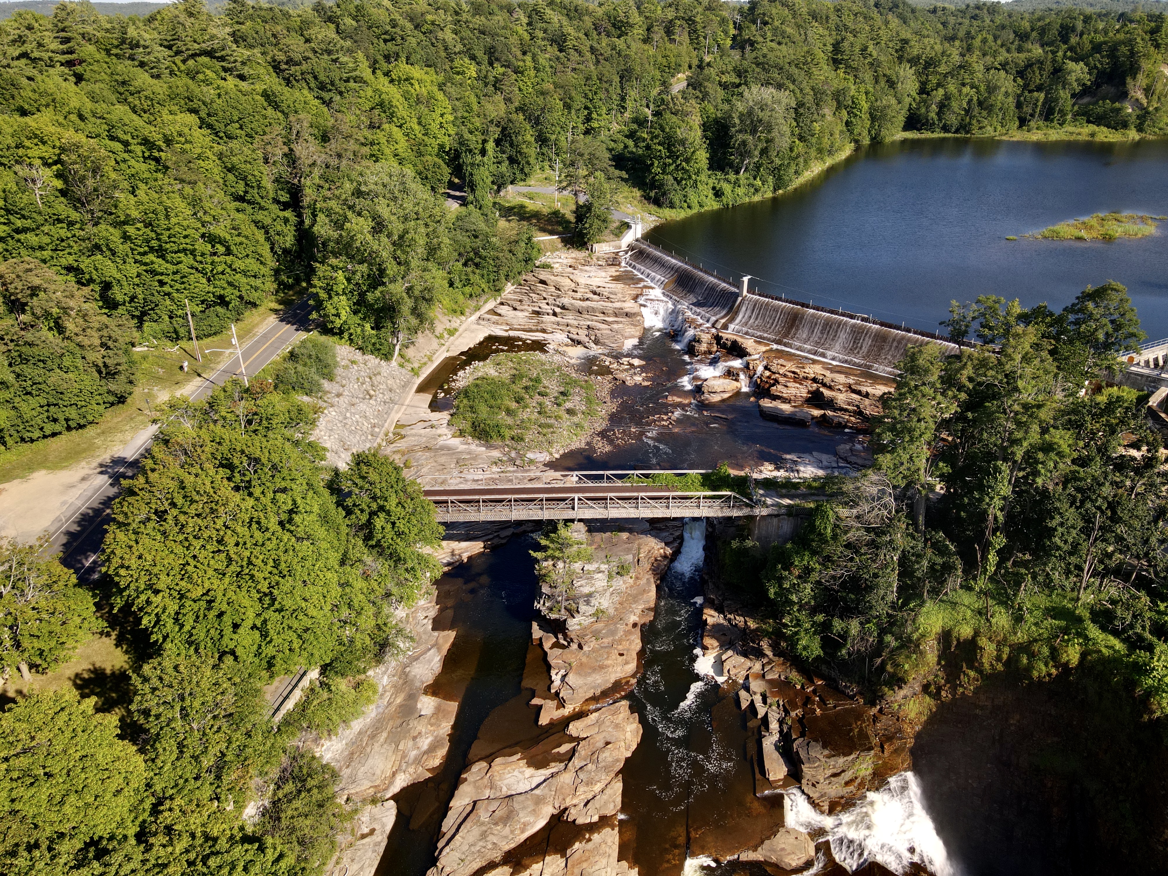
Above: Aerial view of bridge in August, 2020. Click for enlargement. Photo Credit: Small Town Drone.

Above: Aerial view of bridge in August, 2020. Click for enlargement. Photo Credit: Small Town Drone.
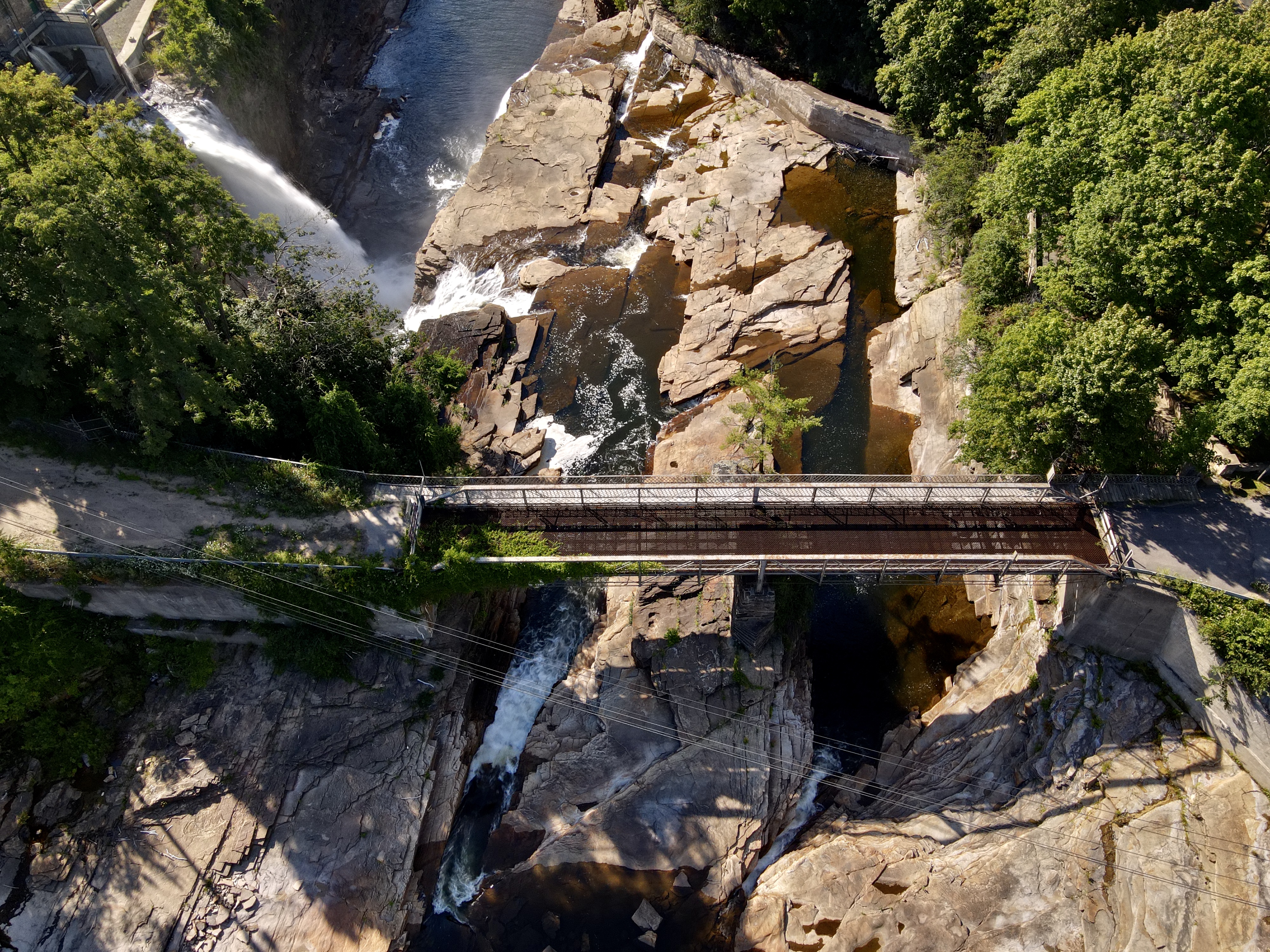
Above: Aerial view of bridge in August, 2020. Click for enlargement. Photo Credit: Small Town Drone.
![]()
![]()
![]()
Coordinates (Latitude, Longitude):
Search For Additional Bridge Listings:
Bridgehunter.com: View listed bridges within 0.5 miles (0.8 kilometers) of this bridge.
Bridgehunter.com: View listed bridges within 10 miles (16 kilometers) of this bridge.
Additional Maps:
Google Streetview (If Available)
GeoHack (Additional Links and Coordinates)
Apple Maps (Via DuckDuckGo Search)
Apple Maps (Apple devices only)
Android: Open Location In Your Map or GPS App
Flickr Gallery (Find Nearby Photos)
Wikimedia Commons (Find Nearby Photos)
Directions Via Sygic For Android
Directions Via Sygic For iOS and Android Dolphin Browser
USGS National Map (United States Only)
Historical USGS Topo Maps (United States Only)
Historic Aerials (United States Only)
CalTopo Maps (United States Only)

© Copyright 2003-2025, HistoricBridges.org. All Rights Reserved. Disclaimer: HistoricBridges.org is a volunteer group of private citizens. HistoricBridges.org is NOT a government agency, does not represent or work with any governmental agencies, nor is it in any way associated with any government agency or any non-profit organization. While we strive for accuracy in our factual content, HistoricBridges.org offers no guarantee of accuracy. Information is provided "as is" without warranty of any kind, either expressed or implied. Information could include technical inaccuracies or errors of omission. Opinions and commentary are the opinions of the respective HistoricBridges.org member who made them and do not necessarily represent the views of anyone else, including any outside photographers whose images may appear on the page in which the commentary appears. HistoricBridges.org does not bear any responsibility for any consequences resulting from the use of this or any other HistoricBridges.org information. Owners and users of bridges have the responsibility of correctly following all applicable laws, rules, and regulations, regardless of any HistoricBridges.org information.
![]()