

View Information About HSR Ratings

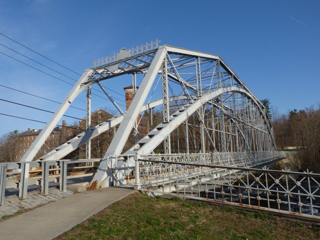
This bridge is noteworthy as a pin-connected Pennsylvania truss. However, it is particularly unusual because it was built by the Berlin Iron Bridge Company. Most surviving pin-connected truss bridges built by this company are the company's patented lenticular truss design, so this bridge stands out as unusual among surviving examples of the company's work. Aside from the variance in the truss design, the other typical Berlin Iron Bridge Company details are present including the design of ornamental railings, portal cresting, and builder plaque. These items remain intact on the bridge today.
The bridge has been altered by the addition of a load-bearing structural arch. This type of alteration significantly reduces the historic integrity of the bridge, but is a good compromise preservation solution for situations where heavy loads need to be able to cross the historic bridge. The sidewalk appears to have been made narrower, although the original dimensions of the sidewalk cantilevers were retained.
This bridge is tagged with the following special condition(s): Trusses Converted To Decorative
![]()
![]()
![]()

![]()
![]()
Coordinates (Latitude, Longitude):
Search For Additional Bridge Listings:
Bridgehunter.com: View listed bridges within 0.5 miles (0.8 kilometers) of this bridge.
Bridgehunter.com: View listed bridges within 10 miles (16 kilometers) of this bridge.
Additional Maps:
Google Streetview (If Available)
GeoHack (Additional Links and Coordinates)
Apple Maps (Via DuckDuckGo Search)
Apple Maps (Apple devices only)
Android: Open Location In Your Map or GPS App
Flickr Gallery (Find Nearby Photos)
Wikimedia Commons (Find Nearby Photos)
Directions Via Sygic For Android
Directions Via Sygic For iOS and Android Dolphin Browser
USGS National Map (United States Only)
Historical USGS Topo Maps (United States Only)
Historic Aerials (United States Only)
CalTopo Maps (United States Only)

© Copyright 2003-2025, HistoricBridges.org. All Rights Reserved. Disclaimer: HistoricBridges.org is a volunteer group of private citizens. HistoricBridges.org is NOT a government agency, does not represent or work with any governmental agencies, nor is it in any way associated with any government agency or any non-profit organization. While we strive for accuracy in our factual content, HistoricBridges.org offers no guarantee of accuracy. Information is provided "as is" without warranty of any kind, either expressed or implied. Information could include technical inaccuracies or errors of omission. Opinions and commentary are the opinions of the respective HistoricBridges.org member who made them and do not necessarily represent the views of anyone else, including any outside photographers whose images may appear on the page in which the commentary appears. HistoricBridges.org does not bear any responsibility for any consequences resulting from the use of this or any other HistoricBridges.org information. Owners and users of bridges have the responsibility of correctly following all applicable laws, rules, and regulations, regardless of any HistoricBridges.org information.
![]()