We Recommend:
Bach Steel - Experts at historic truss bridge restoration.
BridgeHunter.com Phase 1 is released to the public! - Visit Now
Blackhand Gorge Bridge

Primary Photographer(s): Nathan Holth and Rick McOmber
Bridge Documented: June 8, 2014
Rural: Licking County, Ohio: United States
1983
43.0 Feet (13.1 Meters)
Not Available
Not Available
1 Main Span(s)
4532139

View Information About HSR Ratings
Bridge Documentation

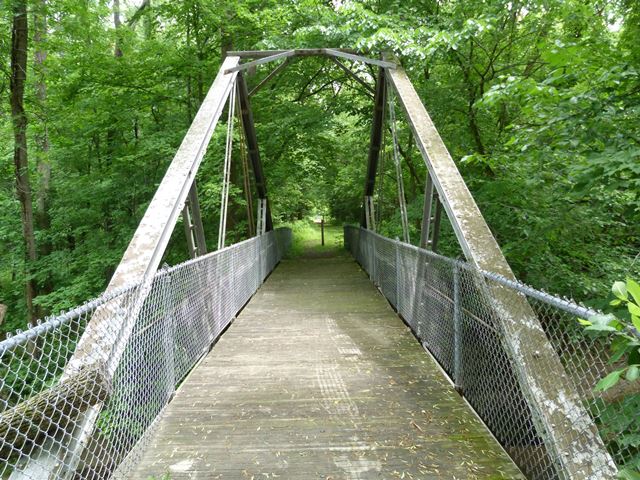
This bridge may be the only one of its kind in existence, thanks to its truly bizarre truss configuration. It is not a Kingpost truss, nor is it famous engineer J. A. L. Waddell's design for an A-frame truss (often classified as a "Waddell A-Frame" yet this bridge is a variety of A-frame truss. It is not known who built the bridge. An 1880 construction date is listed for the bridge, which is plausible given the font on the bridge's Carnegie brands, and the unusual design of the bridge.
This bridge is in a park and is suitable for pedestrian use yet is closed off and not maintained. Given its high significance it needs to be fully restored and preserved!
Information and Findings From Ohio's Historic Bridge InventorySetting/Context The bridge carries an abandoned and closed off bike/pedestrian path over a stream in the Blackhand Gorge State Nature Preserve. In 2009, the trail was totally overgrown. The path is on a former railroad right-of-way. The path is located on old TR 332. Physical Description The 1 span, metal truss bridge is an A-frame thru truss with sub-diagonals. The upper chords are composed of paired channels with cover plate and battens. The diagonal struts are paired angles with long rivets/spacers. The diagonals and lower chords and eyebars. The bridge has a wood deck and chain link fence. The bridge is supported on ashlar abutments from a former railroad bridge at this location. Integrity Floorbeam and deck system replaced in 1983 when bridge relocated. The eyebars of the lower chord at mid-panel are sprung. Summary of Significance The A-frame truss bridge was relocated from TR 332 to Blackhand Gorge in 1983, resulting in some loss of original design due to changes in the floorbeam connections and deck. It is, however, a very rare truss type/design and maintains sufficient integrity to convey its technological significance. The eligible recommendation of the prior inventory remains appropriate. Justification The bridge is rare in Ohio and the nation. It has high significance. Bridge Considered Historic By Survey: Yes |
![]()
Photo Galleries and Videos: Blackhand Gorge Bridge
Bridge Photo-Documentation
Original / Full Size PhotosA collection of overview and detail photos. This gallery offers photos in the highest available resolution and file size in a touch-friendly popup viewer.
Alternatively, Browse Without Using Viewer
![]()
Bridge Photo-Documentation
Mobile Optimized PhotosA collection of overview and detail photos. This gallery features data-friendly, fast-loading photos in a touch-friendly popup viewer.
Alternatively, Browse Without Using Viewer
![]()
Maps and Links: Blackhand Gorge Bridge
Coordinates (Latitude, Longitude):
Search For Additional Bridge Listings:
Bridgehunter.com: View listed bridges within 0.5 miles (0.8 kilometers) of this bridge.
Bridgehunter.com: View listed bridges within 10 miles (16 kilometers) of this bridge.
Additional Maps:
Google Streetview (If Available)
GeoHack (Additional Links and Coordinates)
Apple Maps (Via DuckDuckGo Search)
Apple Maps (Apple devices only)
Android: Open Location In Your Map or GPS App
Flickr Gallery (Find Nearby Photos)
Wikimedia Commons (Find Nearby Photos)
Directions Via Sygic For Android
Directions Via Sygic For iOS and Android Dolphin Browser
USGS National Map (United States Only)
Historical USGS Topo Maps (United States Only)
Historic Aerials (United States Only)
CalTopo Maps (United States Only)

