We Recommend:
Bach Steel - Experts at historic truss bridge restoration.
BridgeHunter.com Phase 1 is released to the public! - Visit Now
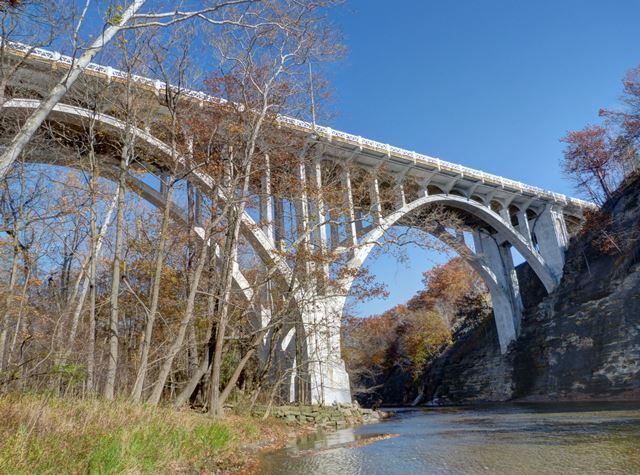
Brookpark Viaduct

Primary Photographer(s): Nathan Holth
Bridge Documented: November 11, 2015
Fairview Park and Cleveland: Cuyahoga County, Ohio: United States
1933 By Builder/Contractor: Highway Construction Company of Cleveland, Ohio and Engineer/Design: D. H. Overman and Ohio State Highway Department
1989
192.0 Feet (58.5 Meters)
1,919.0 Feet (584.9 Meters)
52.2 Feet (15.91 Meters)
8 Main Span(s) and 7 Approach Span(s)
1802046

View Information About HSR Ratings
Bridge Documentation
View Archived National Bridge Inventory Report - Has Additional Details and Evaluation
View Historical Article About This Bridge
This is an impressive and large multi-span concrete arch bridge noted for its attractive design as built by notable state highway department engineer D. H. Overman. The arch span over the river has an unusual shape because the eastern end of the span bears on the steep cliff along the river. Despite its beauty and historic significance, the bridge has been allowed to deteriorated to the point that signs are posted under the bridge warning people of falling concrete. Pieces of concrete were indeed observed under the bridge on the ground.
Above: Historical photo of bridge, showing original railing.
Information and Findings From Ohio's Historic Bridge InventorySetting/Context The bridge carries a 4-lane highway and sidewalks over a deep ravine and parkway in Fairview Park. Physical Description The 15 span, 1,919'-long bridge has open-spandrel arch main spans flanked by T beam approach spans. The high-rise arches are two-ribbed with slender spandrel columns and arched caps supporting a cantilevered deck. The bridge has lancet-arch shaped panels at the piers. The bridge was rehabilitated in 1989, which included replacement railings and cantilevered deck sections to increase the bridge deck width. Integrity Loss of cover material; exposed rebar, crumbling, and spalling. Deck widened and steel railings are new. Summary of Significance "The 1933 open-spandrel arch bridge is one of Ohio's signature bridges designed by D. H. Overman and the state bridge bureau. The setting allows for a high-rise arch, illustrating the architectural lightness and proportions of the open spandrel arch type to great effect. The bridge was rehabilitated in 1989 without adverse effect. The eligible recommendation remains appropriate. There are 25 open spandrel arch bridges dating from 1907 to 1957 in the inventory (Phase 1A, 2008). ""The reinforced concrete open spandrel arch was first constructed around 1906. It was the dominant form for concrete bridges in the 1920s and 1930s. By eliminating the walls and fill material of the closed spandrel, dead loads were reduced and cost savings were seen in materials with the open spandrel. Aesthetics was another factor with the open spandrel. They had a lightness and visual appeal and were used in prominent or scenic locations. Open spandrel construction marked engineering prowess during the 1930s and 1940s. By the 1940s, the open spandrel concrete structure began to be supplanted by the more pre-stressed beam and reinforced concrete girder structures. Open spandrel arch bridges have pierced spandrel wall with no fill material, and the spandrel columns transmit dead and live load from the deck to the arch. The arch ring may be either solid (barrel) or ribbed. Open spandrel arch bridges require more formwork to construct than filled spandrel bridges. Open spandrel concrete arches, while not uncommon, are not as common as many other bridge types built during this same era. They are significant because they represent the evolution of concrete technology. To be considered significant, open spandrel arches should have integrity through the retention of their character-defining features, which include arch ribs, ring or barrel; spandrel; spandrel columns; railing or parapet; and piers, abutments, and wingwalls."" [From: A Context for Common Historic Bridge Types by Parsons Brinckerhoff, October 2005]" Justification Because of the early emphasis on aesthetics at the local and state levels, Ohio has an impressive assemblage of long and shorter open spandrel arch bridges dating from 1907 through World War II. Twenty-three of the 25 predate World War II. This example is the work of D. Henry Overman, considered one of the finest bridge designers of his day. It has extremely high artistic merit. Bridge Considered Historic By Survey: Yes |
![]()
Photo Galleries and Videos: Brookpark Viaduct
Bridge Photo-Documentation
Original / Full Size PhotosA collection of overview and detail photos. This gallery offers photos in the highest available resolution and file size in a touch-friendly popup viewer.
Alternatively, Browse Without Using Viewer
![]()
Bridge Photo-Documentation
Mobile Optimized PhotosA collection of overview and detail photos. This gallery features data-friendly, fast-loading photos in a touch-friendly popup viewer.
Alternatively, Browse Without Using Viewer
![]()
Maps and Links: Brookpark Viaduct
Coordinates (Latitude, Longitude):
Search For Additional Bridge Listings:
Bridgehunter.com: View listed bridges within 0.5 miles (0.8 kilometers) of this bridge.
Bridgehunter.com: View listed bridges within 10 miles (16 kilometers) of this bridge.
Additional Maps:
Google Streetview (If Available)
GeoHack (Additional Links and Coordinates)
Apple Maps (Via DuckDuckGo Search)
Apple Maps (Apple devices only)
Android: Open Location In Your Map or GPS App
Flickr Gallery (Find Nearby Photos)
Wikimedia Commons (Find Nearby Photos)
Directions Via Sygic For Android
Directions Via Sygic For iOS and Android Dolphin Browser
USGS National Map (United States Only)
Historical USGS Topo Maps (United States Only)
Historic Aerials (United States Only)
CalTopo Maps (United States Only)


