

View Information About HSR Ratings
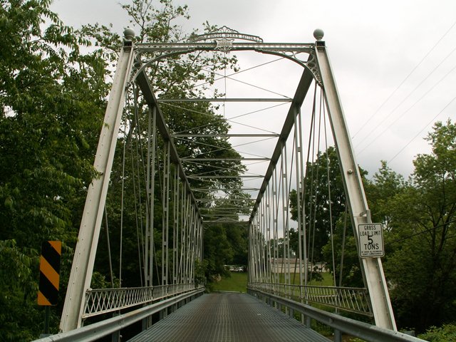
This ancient 1882 bridge uses similar structural parts and design details as the 1881 Carillon Park Bridge which is also a Columbia Bridge Works bridge. These parts are very unusual, and unlike other bridges built during the same period by other bridge companies. Columbia Bridge Works was known for building bridges with unusual design details. From the top chord and end post, to the vertical members, to the unusual connection details, these Columbia Bridge Works were very unusual. This is a very significant bridge for its age, documented association with Columbia Bridge Works, Whipple truss configuration, and decent span length. The Columbia Bridge Works liked to make their bridges look nice, and that is apparent in this bridge through their trademark builder plaque design, and also through the decorative portal bracing. Decorative finials are also present on this bridge, adding to the ornate aesthetic value of the structure.
This bridge is an eleven panel pin connected Whipple truss. The deck has been redone and features a metal grate surface. Original lattice railings remain above modern Armco railings. This bridge has thankfully been rehabilitated in a very high quality and tasteful manner and as a result the bridge is today in good condition, continuing to be a safe and functional crossing. The bridge is both an example to and a striking comparison to nearby Pennsylvania, which claims that rehabilitation of this type is not possible and instead demolishes and replaces bridges like this.
Information and Findings From Ohio's Historic Bridge InventorySetting/Context The bridge carries a 2 lane road over a stream in a sparsely developed, rural setting. Physical Description The 1 span, 160'-long, pin-connected Whipple truss bridge has built-up compression members and eyebar or rod tension members. It is finished with lattice railings and has portal bracing with decorative brackets and ball finials. Integrity Rehabilitated/galvanized floor system added, 2001. This is a superb bridge that is extremely well preserved by the county. Summary of Significance Although the flooring system has been modified, the truss lines maintain their integrity of design and materials. The 1882 Whipple truss fabricated by the Columbia Bridge Works is an increasingly rare and significant example of its type/design. The eligible recommendation of the prior inventory remains appropriate. Double-intersection Pratt trusses, also known as Whipple or Murphy-Whipple trusses, were among the most successful of long-span thru truss designs (up to 300' long) of the 1860s to 1890s for both railroad and vehicular crossings. Surviving examples are uncommon nationally and considered technologically significant; Ohio with at least 14 identified examples dating from 1881 to 1898 (Phase 1A survey, 2008) has a very high number in comparison to most other states. The truss design is characterized by diagonals that extend over two panels. In 1847, Squire Whipple, one of America's foremost bridge engineers, developed the design figuring that the double-intersection configuration increased the depth of panel without altering the optimal angle of the diagonals, thus allowing for increased span length. His design was further refined in 1859 by John W. Murphy, the talented chief engineer of Pennsylvania's Lehigh Valley RR, who substituted wrought-iron pins for cast-iron connecting pieces, thus developing the connection detail that would prove to be advanced construction practice for this and other truss designs for the next several decades. Ohio's surviving examples, which mostly date to the 1880s, were not cutting edge for their time, but they show how the form had evolved into the preferred long-span thru truss design of the period. Most have documented associations with prominent Ohio-based fabricators. Justification The bridge ranks as one of the finest examples of a Columbia Bridge Works thru truss with idiosyncratic details particular to the company. It is also an exemplary rehabilitation. Bridge Considered Historic By Survey: Yes |
![]()
![]()
![]()
Coordinates (Latitude, Longitude):
Search For Additional Bridge Listings:
Bridgehunter.com: View listed bridges within 0.5 miles (0.8 kilometers) of this bridge.
Bridgehunter.com: View listed bridges within 10 miles (16 kilometers) of this bridge.
Additional Maps:
Google Streetview (If Available)
GeoHack (Additional Links and Coordinates)
Apple Maps (Via DuckDuckGo Search)
Apple Maps (Apple devices only)
Android: Open Location In Your Map or GPS App
Flickr Gallery (Find Nearby Photos)
Wikimedia Commons (Find Nearby Photos)
Directions Via Sygic For Android
Directions Via Sygic For iOS and Android Dolphin Browser
USGS National Map (United States Only)
Historical USGS Topo Maps (United States Only)
Historic Aerials (United States Only)
CalTopo Maps (United States Only)

© Copyright 2003-2026, HistoricBridges.org. All Rights Reserved. Disclaimer: HistoricBridges.org is a volunteer group of private citizens. HistoricBridges.org is NOT a government agency, does not represent or work with any governmental agencies, nor is it in any way associated with any government agency or any non-profit organization. While we strive for accuracy in our factual content, HistoricBridges.org offers no guarantee of accuracy. Information is provided "as is" without warranty of any kind, either expressed or implied. Information could include technical inaccuracies or errors of omission. Opinions and commentary are the opinions of the respective HistoricBridges.org member who made them and do not necessarily represent the views of anyone else, including any outside photographers whose images may appear on the page in which the commentary appears. HistoricBridges.org does not bear any responsibility for any consequences resulting from the use of this or any other HistoricBridges.org information. Owners and users of bridges have the responsibility of correctly following all applicable laws, rules, and regulations, regardless of any HistoricBridges.org information.
![]()