We Recommend:
Bach Steel - Experts at historic truss bridge restoration.
BridgeHunter.com Phase 1 is released to the public! - Visit Now
OH-82 Chippewa Creek Bridge

Primary Photographer(s): Nathan Holth
Bridge Documented: August 24, 2019
Brecksville: Cuyahoga County, Ohio: United States
1932 By Builder/Contractor: Unknown and Engineer/Design: D. H. Overman and Ohio State Highway Department
1997
70.0 Feet (21.3 Meters)
73.2 Feet (22.3 Meters)
36 Feet (10.97 Meters)
1 Main Span(s)
1807269

View Information About HSR Ratings
Bridge Documentation
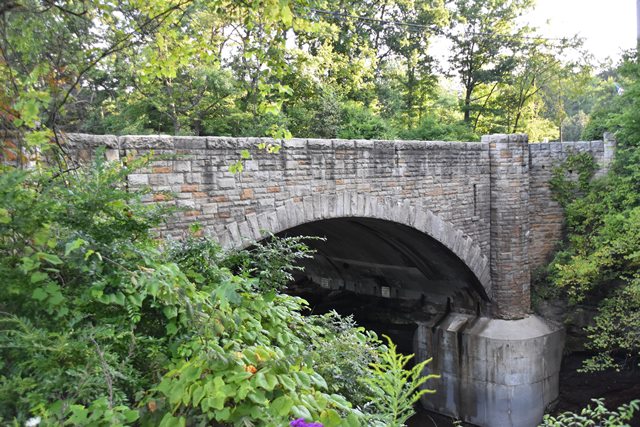
This bridge was designed as a stone faced concrete arch bridge to blend in with its scenic setting.
View Archived National Bridge Inventory Report - Has Additional Details and Evaluation
Information and Findings From Ohio's Historic Bridge InventorySetting/Context The bridge carries a 2-lane state highway over a stream in a mixed use setting in Brecksville. The commercial center of the town is to the west, and the south side of the bridge is in Metroparks Brecksville Reservation. The bridge is at the entrance to the park. Physical Description The 1 span reinforced concrete arch bridge is finished with a rusticated, random ashlar sandstone veneer to the spandrel walls and crenellated parapets, which are accented with refuges. The arch is articulated with staggered voussoirs. The bridge is well proportioned and appears complete save for a massive toe wall placed on the east side. Integrity The large toe wall has been added at the stream on the east side. It is not in keeping with the styling of the bridge. Summary of Significance The handsome reinforced-concrete arch bridge with stone veneer was designed by D. H. Overman, the state bridge bureau's principal design engineer who was noted for his well-executed and proportioned arch designs. The bridge was rehabilitated in 1997 without adverse effect. The eligible recommendation of the prior inventory remains appropriate. Justification The bridge is representative of the fine aesthetic designs produced by the state highway department's bridge division in the 1930s for sensitive settings. There are over 12 examples of the type and design in the state. Bridge Considered Historic By Survey: Yes |
![]()
Photo Galleries and Videos: OH-82 Chippewa Creek Bridge
Bridge Photo-Documentation
Original / Full Size PhotosA collection of overview and detail photos. This gallery offers photos in the highest available resolution and file size in a touch-friendly popup viewer.
Alternatively, Browse Without Using Viewer
![]()
Bridge Photo-Documentation
Mobile Optimized PhotosA collection of overview and detail photos. This gallery features data-friendly, fast-loading photos in a touch-friendly popup viewer.
Alternatively, Browse Without Using Viewer
![]()
Maps and Links: OH-82 Chippewa Creek Bridge
Coordinates (Latitude, Longitude):
Search For Additional Bridge Listings:
Bridgehunter.com: View listed bridges within 0.5 miles (0.8 kilometers) of this bridge.
Bridgehunter.com: View listed bridges within 10 miles (16 kilometers) of this bridge.
Additional Maps:
Google Streetview (If Available)
GeoHack (Additional Links and Coordinates)
Apple Maps (Via DuckDuckGo Search)
Apple Maps (Apple devices only)
Android: Open Location In Your Map or GPS App
Flickr Gallery (Find Nearby Photos)
Wikimedia Commons (Find Nearby Photos)
Directions Via Sygic For Android
Directions Via Sygic For iOS and Android Dolphin Browser
USGS National Map (United States Only)
Historical USGS Topo Maps (United States Only)
Historic Aerials (United States Only)
CalTopo Maps (United States Only)

