We Recommend:
Bach Steel - Experts at historic truss bridge restoration.
BridgeHunter.com Phase 1 is released to the public! - Visit Now
CR-T Bridge

Primary Photographer(s): Nathan Holth
Bridge Documented: Fall/Winter 2006 and November 6, 2021
Rural: Fulton County, Ohio: United States
1930 By Builder/Contractor: American Bridge Company of New York, New York
1985
100.0 Feet (30.5 Meters)
101.0 Feet (30.8 Meters)
28 Feet (8.53 Meters)
1 Main Span(s)
2632012

View Information About HSR Ratings
Bridge Documentation
View Archived National Bridge Inventory Report - Has Additional Details and Evaluation
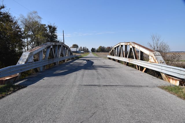
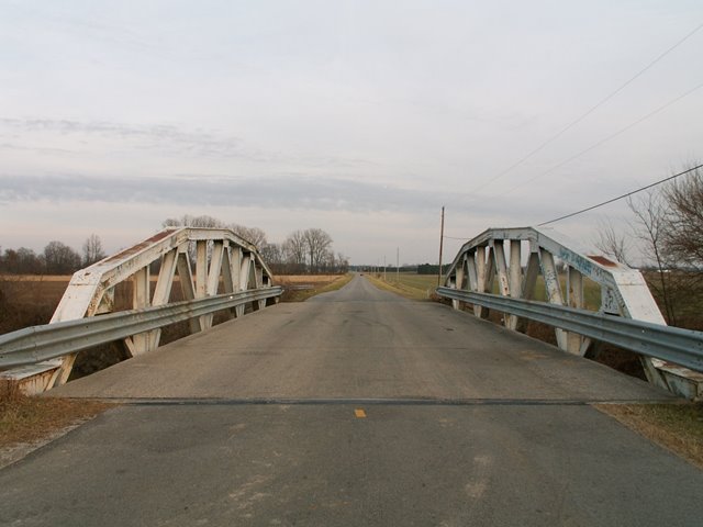
This bridge is within sight of the Michigan border a mile north. It is however unlike most bridges built in Michigan, which preferred concrete girder and steel stringer bridges over the metal truss bridge in the 20th century. This bridge has lost its original railings, and because of its lack of v-lacing and lattice, it could easily be mistaken for one of Ohio's infamous modern, non-historic welded truss bridges when viewed from nearby SR-108. The only lattice on the bridge is under the top chord, and no v-lacing is present on the bridge. As 28 feet, the bridge has a fairly wide deck, wider perhaps than one might expect from 1930, when the 20-24 foot deck was a more common width for a rural road. Some connections have bolts on them instead of rivets, most likely the result of some repair project.
This bridge is tagged with the following special condition(s): Unorganized Photos
![]()
Photo Galleries and Videos: CR-T Bridge
Bridge Photo-Documentation
Original / Full Size PhotosA collection of overview and detail photos. This gallery offers photos in the highest available resolution and file size in a touch-friendly popup viewer.
Alternatively, Browse Without Using Viewer
![]()
Bridge Photo-Documentation
Mobile Optimized PhotosA collection of overview and detail photos. This gallery features data-friendly, fast-loading photos in a touch-friendly popup viewer.
Alternatively, Browse Without Using Viewer
![]()
Additional Unorganized Photos
Original / Full Size PhotosA supplemental collection of photos that are from additional visit(s) to the bridge and have not been organized or captioned. This gallery offers photos in the highest available resolution and file size in a touch-friendly popup viewer.
Alternatively, Browse Without Using Viewer
![]()
Additional Unorganized Photos
Mobile Optimized PhotosA supplemental collection of photos that are from additional visit(s) to the bridge and have not been organized or captioned. This gallery features data-friendly, fast-loading photos in a touch-friendly popup viewer.
Alternatively, Browse Without Using Viewer
![]()
Maps and Links: CR-T Bridge
Coordinates (Latitude, Longitude):
Search For Additional Bridge Listings:
Bridgehunter.com: View listed bridges within 0.5 miles (0.8 kilometers) of this bridge.
Bridgehunter.com: View listed bridges within 10 miles (16 kilometers) of this bridge.
Additional Maps:
Google Streetview (If Available)
GeoHack (Additional Links and Coordinates)
Apple Maps (Via DuckDuckGo Search)
Apple Maps (Apple devices only)
Android: Open Location In Your Map or GPS App
Flickr Gallery (Find Nearby Photos)
Wikimedia Commons (Find Nearby Photos)
Directions Via Sygic For Android
Directions Via Sygic For iOS and Android Dolphin Browser
USGS National Map (United States Only)
Historical USGS Topo Maps (United States Only)
Historic Aerials (United States Only)
CalTopo Maps (United States Only)


