

View Information About HSR Ratings
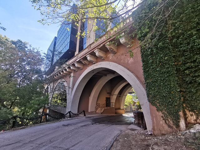
Although the record-breaking main span of this arch bridge was demolished many years ago, the approach spans at the west end of the bridge were reused as building foundations. Certainly, this is one of the more unusual adaptive reuses of a bridge. The rest of the bridge was demolished in 1980 following a bridge replacement project. The western approach spans remained until 1989 when a new 35,000 square foot building was constructed on top of them, under the direction of Cleveland-based developer John Ferchill. Some of the windows of the building fill the arches of the bridge. One of the spans remains open and can be driven under. The building itself is known as the Bridge Building, with an address of 18500 Lake Road.
The missing main span of this bridge was the longest unreinforced concrete arch span when constructed.
Original plans for the bridge are available for download. In these plans is a proposed multi-span design that was proposed but never built.
Dimensions and bridge type given are for the bridge prior to demolition.
Alfred M. Felgate was the engineer for the bridge, and he was associated with the county. Wilber J. Watson and Associates was the contractor's engineer who assisted with the centering for the bridge.
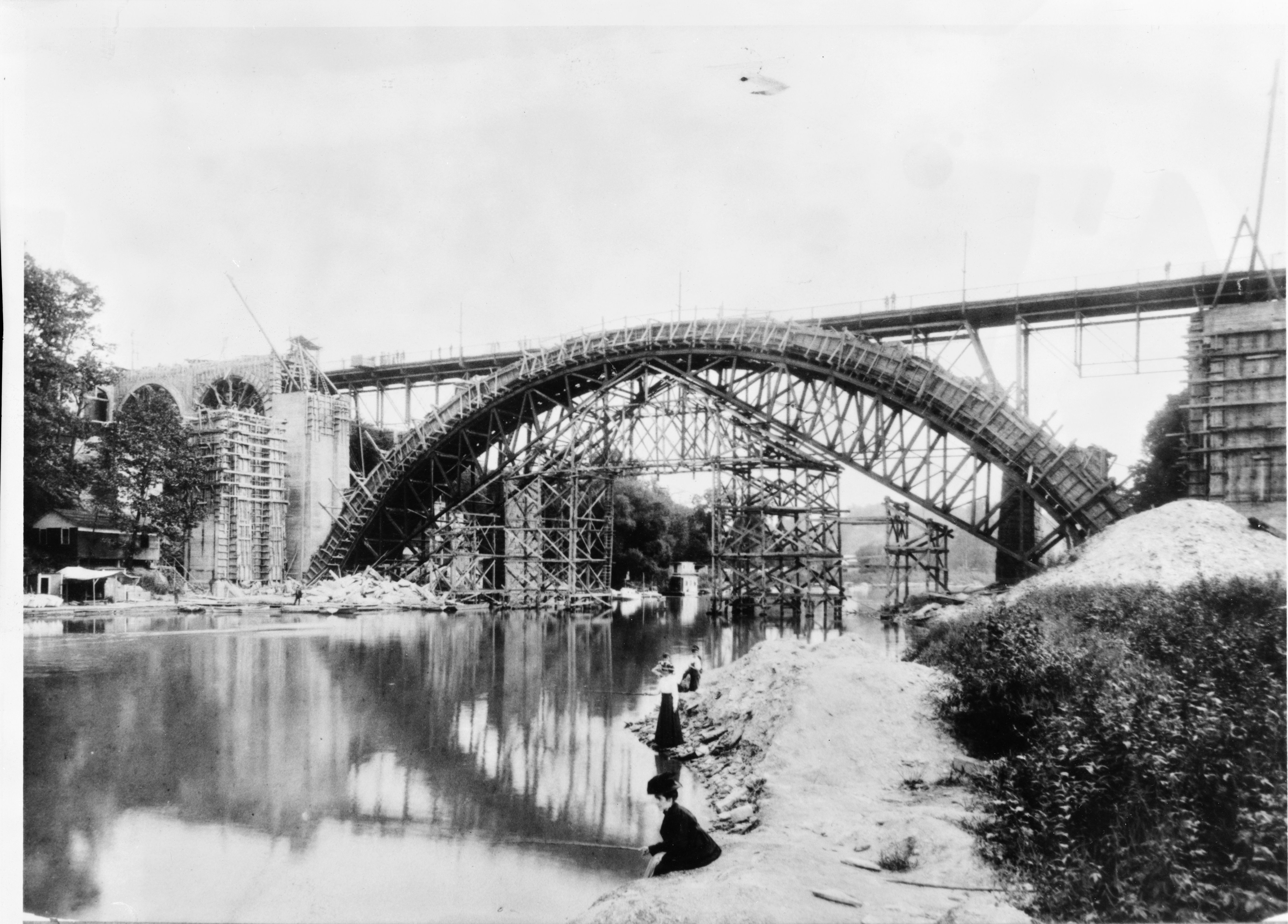
Above: Historical photo showing bridge construction.
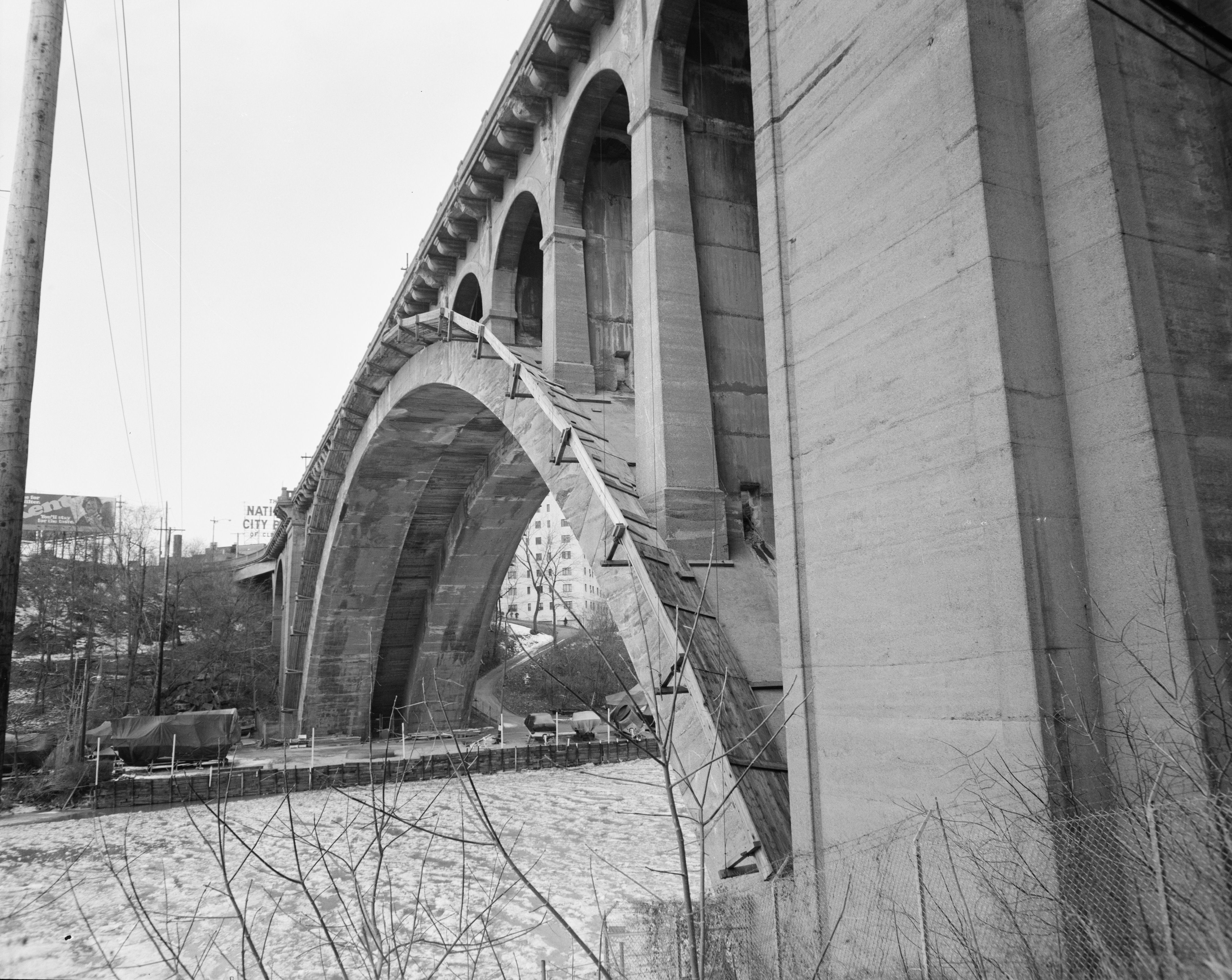
Above: Historical HAER photo showing bridge before demolition.

Above: Historical HAER photo showing bridge before demolition.
![]()
![]()
![]()
Coordinates (Latitude, Longitude):
Search For Additional Bridge Listings:
Bridgehunter.com: View listed bridges within 0.5 miles (0.8 kilometers) of this bridge.
Bridgehunter.com: View listed bridges within 10 miles (16 kilometers) of this bridge.
Additional Maps:
Google Streetview (If Available)
GeoHack (Additional Links and Coordinates)
Apple Maps (Via DuckDuckGo Search)
Apple Maps (Apple devices only)
Android: Open Location In Your Map or GPS App
Flickr Gallery (Find Nearby Photos)
Wikimedia Commons (Find Nearby Photos)
Directions Via Sygic For Android
Directions Via Sygic For iOS and Android Dolphin Browser
USGS National Map (United States Only)
Historical USGS Topo Maps (United States Only)
Historic Aerials (United States Only)
CalTopo Maps (United States Only)

© Copyright 2003-2026, HistoricBridges.org. All Rights Reserved. Disclaimer: HistoricBridges.org is a volunteer group of private citizens. HistoricBridges.org is NOT a government agency, does not represent or work with any governmental agencies, nor is it in any way associated with any government agency or any non-profit organization. While we strive for accuracy in our factual content, HistoricBridges.org offers no guarantee of accuracy. Information is provided "as is" without warranty of any kind, either expressed or implied. Information could include technical inaccuracies or errors of omission. Opinions and commentary are the opinions of the respective HistoricBridges.org member who made them and do not necessarily represent the views of anyone else, including any outside photographers whose images may appear on the page in which the commentary appears. HistoricBridges.org does not bear any responsibility for any consequences resulting from the use of this or any other HistoricBridges.org information. Owners and users of bridges have the responsibility of correctly following all applicable laws, rules, and regulations, regardless of any HistoricBridges.org information.
![]()