We Recommend:
Bach Steel - Experts at historic truss bridge restoration.
BridgeHunter.com Phase 1 is released to the public! - Visit Now
Factory Road Bridge
TR-341 Bridge

Primary Photographer(s): Nathan Holth
Bridge Documented: May 7, 2006
Rural: Preble County, Ohio: United States
Not Available or Not Applicable
48.0 Feet (14.6 Meters)
55.0 Feet (16.8 Meters)
15.7 Feet (4.79 Meters)
1 Main Span(s)
6838154

View Information About HSR Ratings
Bridge Documentation
This bridge no longer exists!
View Archived National Bridge Inventory Report - Has Additional Details and Evaluation
This bridge was demolished and replaced in 2010!
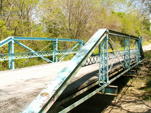
Steel on the bridge was fabricated by Carnegie as well as Jones and Laughlins, as marked on the bridge's members. If the bridge really was built in 1914 (which could be questioned), than the bridge was built from steel that likely had been laying around for a while. Jones and Laughlins dropped the second "s" and became Jones and Laughlin around 1905, thus the Laughlins found on the steel of this bridge suggests pre-1905 origins. The vertical members of this bridge are lightweight latticed members. Original lattice railings remain on the bridge. The bridge sits on stone abutments. The deck is wood with an asphalt wearing surface. Eyebars on the bridge are of the loop-forged variety. A couple turnbuckles were replaced on the bridge. The bridge was posted for a generous 28 ton weight limit in 2006. While the bridge was certainly strong enough to serve local traffic, and with a restoration could have continued to do that and more for decades to come, as it was, the bridge was instead demolished and replaced. This represents a strong bias in the county. The fact that the county has preserved wooden covered bridges, yet is seeking to demolish metal truss bridges, represents one of the core issues that HistoricBridges.org seeks to expose. Is a a pin connected through truss any less deserving of preservation than a covered bridge? Absolutely not! But time and time again the wooden covered bridges are preserved while the truss bridges fall. Oddly enough, truss bridges are more durable and strong when properly maintained as well, and it is easier to retain their historic integrity during rehabilitation.
![]()
Photo Galleries and Videos: Factory Road Bridge
Bridge Photo-Documentation
Original / Full Size PhotosA collection of overview and detail photos. This gallery offers photos in the highest available resolution and file size in a touch-friendly popup viewer.
Alternatively, Browse Without Using Viewer
![]()
Bridge Photo-Documentation
Mobile Optimized PhotosA collection of overview and detail photos. This gallery features data-friendly, fast-loading photos in a touch-friendly popup viewer.
Alternatively, Browse Without Using Viewer
![]()
Maps and Links: Factory Road Bridge
This historic bridge has been demolished. This map is shown for reference purposes only.
Coordinates (Latitude, Longitude):
Search For Additional Bridge Listings:
Bridgehunter.com: View listed bridges within 0.5 miles (0.8 kilometers) of this bridge.
Bridgehunter.com: View listed bridges within 10 miles (16 kilometers) of this bridge.
Additional Maps:
Google Streetview (If Available)
GeoHack (Additional Links and Coordinates)
Apple Maps (Via DuckDuckGo Search)
Apple Maps (Apple devices only)
Android: Open Location In Your Map or GPS App
Flickr Gallery (Find Nearby Photos)
Wikimedia Commons (Find Nearby Photos)
Directions Via Sygic For Android
Directions Via Sygic For iOS and Android Dolphin Browser
USGS National Map (United States Only)
Historical USGS Topo Maps (United States Only)
Historic Aerials (United States Only)
CalTopo Maps (United States Only)

