We Recommend:
Bach Steel - Experts at historic truss bridge restoration.
BridgeHunter.com Phase 1 is released to the public! - Visit Now
Junction Road Hopewell Creek Bridge
TR-259 Bridge

Primary Photographer(s): Nathan Holth
Bridge Documented: May 7, 2006
Rural: Preble County, Ohio: United States
By Builder/Contractor: Indianapolis Bridge Company of Indianapolis, Indiana
Not Available or Not Applicable
57.0 Feet (17.4 Meters)
62.0 Feet (18.9 Meters)
15.7 Feet (4.79 Meters)
1 Main Span(s)
6841287

View Information About HSR Ratings
Bridge Documentation
This bridge no longer exists!
View Archived National Bridge Inventory Report - Has Additional Details and Evaluation
This historic bridge was demolished August 2011!
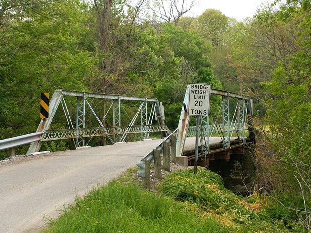
This bridge is a four panel pin connected half-hip Pratt pony truss bridge. It retains original lattice railings. V-lacing is present on the vertical members. A Jones and Laughlin brand was found on the metal of the bridge. The bridge sits on concrete abutments. The deck is wooden with an asphalt wearing surface. The bridge retains fair historic integrity, however on the eastern half of the southern truss, steel was bolted to the inside of the top chord on the bridge.
Why Preble County could preserve the more significant Junction Road Bowstring Bridge but demolished and replaced this historic metal truss bridge does not make sense. They put beams under the bowstring bridge, so the truss isn't actually functional anymore, but it still looks a lot nicer and is more historic than a replacement bridge. There is no reason why they could not have done the same here. Why waste money on building a modern two-lane bridge on a road with low volumes of traffic on a corridor that already has a preserved one-lane bridge on it?
Information and Findings From Ohio's Historic Bridge InventorySetting/Context The bridge carries a 2-lane road over a stream in a rural setting of active agriculture. Fields and/or wooded lots are at the bridge's adjacent quadrants. The road necks down at the 16'-wide bridge, which is on an S-curve. Physical Description The 1-span, 62'-long, pin-connected Pratt pony truss bridge is conventionally composed with built-up compression members and eyebar tension members. The upper chords are toe-out channels with cover plate and battens. At least two panels of the upper chord on one truss have been irreversibly altered by strengthening with beams bolted to the inside of the channels and the battens replaced by welding. The verticals are angles with lacing bars. The end posts have section loss and at least one has an irreversible welded repair with the addition of material as a strengthening measure. Sign posts have been welded to the end post cover plates. U-shaped hangers at the lower panel points support rolled floorbeams, but although this is the original connection method, it appears that several of the hangers have been replaced and several of the remaining older hangers are bent. The flooring system has been rebuilt/strengthened with extra lines of transverse floorbeams added between the panel points by welding the beams to the lower flanges of the stringers. The lower lateral cross-bracing rods have either been lost, damaged, and/or broken. Some rods have been welded to the floorbeams. The bridge has riveted lattice railings and a timber deck. The builder's plaque at the end post has been broken and half of it lost with only the words "Bridge Company, Muncie, Ind." remaining. The bridge is supported on concrete abutments. Integrity The integrity of original design has been impacted by irreversible welded repairs and strengthening measures (upper chord, end posts, lower lateral bracing). The repairs are judged to date ca. 1970. Summary of Significance The ca. 1905 Pratt pony truss bridge is conventionally composed and a later example of its design by the Indiana Bridge Co. (IBCo), a prolific builder in Indiana and adjacent states. None of the truss details are
technologically significant. As well, there are alterations that have had an impact on the integrity of design. There are more complete and distinguished examples of pin-connected trusses in the county, including some distinguished
examples by this fabricator (6842364, 6833861, 6831826, 6838235). Although the date of construction of this bridge is not documented by available county engineering records, it is judged ca. 1905 based on the conventional design and
comparison with other documented IBCo bridges in the county, which all date to the mid to late 1900s. The not eligible recommendation of the prior ODOT inventory remains appropriate. Bridge Considered Historic By Survey: No |
![]()
Photo Galleries and Videos: Junction Road Hopewell Creek Bridge
Bridge Photo-Documentation
Original / Full Size PhotosA collection of overview and detail photos. This gallery offers photos in the highest available resolution and file size in a touch-friendly popup viewer.
Alternatively, Browse Without Using Viewer
![]()
Bridge Photo-Documentation
Mobile Optimized PhotosA collection of overview and detail photos. This gallery features data-friendly, fast-loading photos in a touch-friendly popup viewer.
Alternatively, Browse Without Using Viewer
![]()
Maps and Links: Junction Road Hopewell Creek Bridge
This historic bridge has been demolished. This map is shown for reference purposes only.
Coordinates (Latitude, Longitude):
Search For Additional Bridge Listings:
Bridgehunter.com: View listed bridges within 0.5 miles (0.8 kilometers) of this bridge.
Bridgehunter.com: View listed bridges within 10 miles (16 kilometers) of this bridge.
Additional Maps:
Google Streetview (If Available)
GeoHack (Additional Links and Coordinates)
Apple Maps (Via DuckDuckGo Search)
Apple Maps (Apple devices only)
Android: Open Location In Your Map or GPS App
Flickr Gallery (Find Nearby Photos)
Wikimedia Commons (Find Nearby Photos)
Directions Via Sygic For Android
Directions Via Sygic For iOS and Android Dolphin Browser
USGS National Map (United States Only)
Historical USGS Topo Maps (United States Only)
Historic Aerials (United States Only)
CalTopo Maps (United States Only)

