

View Information About HSR Ratings
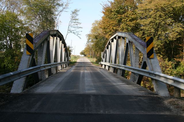
With a length of over 100 feet, this is a very long pony truss span. The visual result of that fact is a very tall and impressive pony truss bridge. The bridge is composed of built-up beams although there is no lattice or v-lacing except under the top chord and end post which is v-laced. The bridge is a rare surviving example of a bridge built by the Elkhart Bridge and Iron Company. Original railings do not remain on the bridge and have been replaced by Armco guardrails which are not properly mounted so as to protect the superstructure from collision damage. Properly mounted guardrails is essential not only to preserve the historic bridge, but also to ensure maximum bridge safety.
This bridge is also a relatively early polygonal Warren pony truss, since most Warren truss bridges with a polygonal top chord date to 1920 and later.
Information and Findings From Ohio's Historic Bridge InventorySetting/Context The bridge carries a 2 lane road over a stream in a sparsely developed, rural setting. Physical Description The 6-panel, 105'-long, riveted Parker pony truss bridge is supported on concrete abutments. The members are built up. The flooring system was replaced/modified using what appears to be salvaged material in 1987. There are no innovative or distinctive details. Integrity The riveted Parker pony truss bridge was designed by R. M. Strohl (plans undated) and fabricated by the Elkhart Bridge & Iron Co. (shop drawings dated 1916). Summary of Significance The Parker thru truss bridge was built in 1916 and is a later example of what was by 1916 a very common bridge type and design. The bridge is traditionally composed and exhibits no innovative or distinctive
details, other than some detailing at the gusset plates which is equally well represented by longer and/or earlier bridges. It is representative of a bridge type and design as well as methods of fabrication that had been used for
span lengths greater than 100' since the last quarter of the 19th century. Bridge Considered Historic By Survey: No |
![]()
![]()
![]()
This historic bridge has been demolished. This map is shown for reference purposes only.
Coordinates (Latitude, Longitude):
Search For Additional Bridge Listings:
Bridgehunter.com: View listed bridges within 0.5 miles (0.8 kilometers) of this bridge.
Bridgehunter.com: View listed bridges within 10 miles (16 kilometers) of this bridge.
Additional Maps:
Google Streetview (If Available)
GeoHack (Additional Links and Coordinates)
Apple Maps (Via DuckDuckGo Search)
Apple Maps (Apple devices only)
Android: Open Location In Your Map or GPS App
Flickr Gallery (Find Nearby Photos)
Wikimedia Commons (Find Nearby Photos)
Directions Via Sygic For Android
Directions Via Sygic For iOS and Android Dolphin Browser
USGS National Map (United States Only)
Historical USGS Topo Maps (United States Only)
Historic Aerials (United States Only)
CalTopo Maps (United States Only)

© Copyright 2003-2026, HistoricBridges.org. All Rights Reserved. Disclaimer: HistoricBridges.org is a volunteer group of private citizens. HistoricBridges.org is NOT a government agency, does not represent or work with any governmental agencies, nor is it in any way associated with any government agency or any non-profit organization. While we strive for accuracy in our factual content, HistoricBridges.org offers no guarantee of accuracy. Information is provided "as is" without warranty of any kind, either expressed or implied. Information could include technical inaccuracies or errors of omission. Opinions and commentary are the opinions of the respective HistoricBridges.org member who made them and do not necessarily represent the views of anyone else, including any outside photographers whose images may appear on the page in which the commentary appears. HistoricBridges.org does not bear any responsibility for any consequences resulting from the use of this or any other HistoricBridges.org information. Owners and users of bridges have the responsibility of correctly following all applicable laws, rules, and regulations, regardless of any HistoricBridges.org information.
![]()