We Recommend:
Bach Steel - Experts at historic truss bridge restoration.
BridgeHunter.com Phase 1 is released to the public! - Visit Now
Market Street Bridge

Primary Photographer(s): Nathan Holth and Rick McOmber
Bridge Documented: July 3, 2006, July 31, 2007, September 26, 2011, and November 4, 2019
Steubenville and East Steubenville: Jefferson County, Ohio and Brooke County, West Virginia: United States
Metal Through Truss Stiffening Wire Cable Suspension, Fixed and Approach Spans: Metal 7 Panel Rivet-Connected Double-Intersection Warren Through Truss, Fixed
1905 By Builder/Contractor: Ohio Steel Erection Company and Engineer/Design: Edwin Kirtland Morse of Pittsburgh, Pennsylvania
1981
680.0 Feet (207.3 Meters)
1,794.0 Feet (546.8 Meters)
20.7 Feet (6.31 Meters)
3 Main Span(s) and 8 Approach Span(s)
4100964

View Information About HSR Ratings
Bridge Documentation
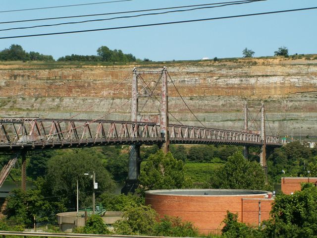
This bridge is an old but heavily altered suspension bridge. The bridge was built in 1905 originally to carry light rail traffic. Penn Bridge Company was the fabricator, and Ohio Steel Erection Company was the on-site contractor. In 1922, the top chord of the bridge failed, and David Steinman (later engineer for Mackinac Bridge) designed repairs for the bridge that also increased its load-bearing capacity. The bridge which had apparently been owned by a private entity called the "Steubenville Bridge Company" was bought by the state of West Virginia in 1941, who then made repairs to the towers and replaced the deck. The bridge was also apparently a toll bridge until 1953.
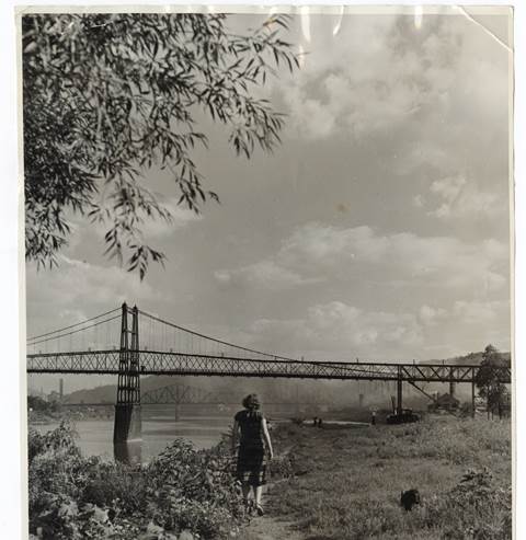
ca. 1939 he bridge was altered from its original construction when the entire main section of stiffening truss was replaced with a modern equivalent. The new trusses were of welded construction which in 1939 would have been one of the earliest uses of welded steel construction in a bridge of this size. The approach truss spans remain original. Original steel on the bridge was fabricated by Jones and Laughlins and Bethlehem.
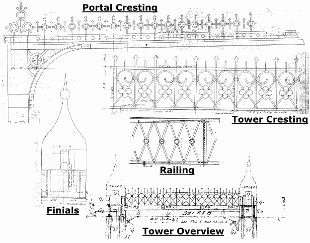
Perhaps the most devastating alteration to this bridge however is the loss of massive decorative finials that were originally placed on the towers, as well as extremely ornate decorative cresting that was present on the top of the towers and on the portal bracing as well. It is hard to imagine how anyone could authorize the removal of such beautiful adornments from a bridge. It would be nice to see these elements replicated and reinstalled on the bridge as part of a comprehensive preservation project. The elements are detailed at the bottom of this page. Click on labels for enlargement.
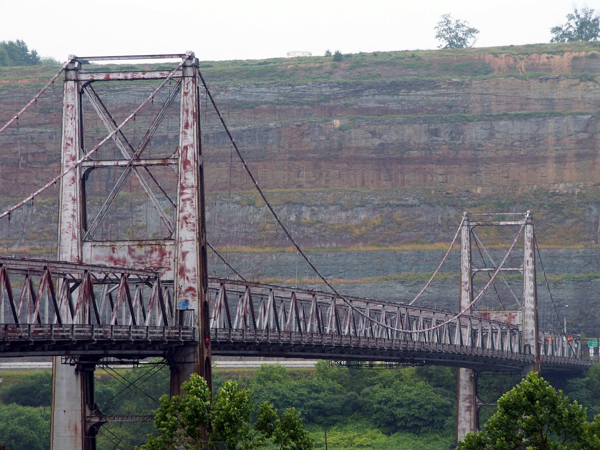
In 2011, the bridge received another rehabilitation and was also repainted in a distinctive two-color paint scheme.
View Archived National Bridge Inventory Report - Has Additional Details and Evaluation
View Historical Articles About This Bridge
View A Detailed Narrative Describing The History of This Bridge

Above: Historical photo showing bridge with original stiffening truss.

Information and Findings From Ohio's Historic Bridge InventorySetting/Context This bridge was built in 1905 originally to carry light rail traffic. In 1922, the top chord of the bridge failed, and David Steinman designed repairs for the toll bridge that also increased its load-bearing capacity. The bridge which had been owned the Steubenville Bridge Company was bought by the state of West Virginia in 1941, which then made repairs to the towers and replaced the deck. Approach spans cross Ohio roads, and it is the approach spans that are reported to BMS; the main span is reported through WV BMS. Physical Description The main span is a suspension span with 1,200' overall length and a 600' center span. The approach spans over SR 7 on the Ohio side are Warren thru trusses. Integrity This bridge is in Ohio BMS because approach spans cross an Ohio highway; the main span is reported through WV. There has been no significant change in the bridge's status since the prior evaluation. The eligible recommendation remains appropriate. The BMS No. 4100964 in the ODOT inventory refers to the approach spans on the Ohio side of the bridge over SR 7. They are, however, historically part of the 1905 suspension bridge and are eligible in association. The suspension bridge is owned by WV and carried as eligible in WVDOT's historic bridge inventory as well as ODOT's inventory. Summary of Significance The bridge is one of the 10 suspension bridges. The bridge type is used for both pedestrian and vehicular bridges starting with Roebling's 1856-67 Cincinnati bridge. This example is representative of its population and has a moderate level of significance. Justification Not Currently Available. Bridge Considered Historic By Survey: Yes View PDF Historic Bridge Inventory Sheet Information and Findings From West Virginia Department of HighwaysOverview The Market Street Bridge was completed in 1905 as a project of the
Steubenville Bridge Company, an organization that appears to have been
formed solely for the purpose of constructing the bridge. The structure
was originally built to carry streetcar and pedestrian traffic over the
Ohio River between the town of Steubenville and the towns along the
river in West Virginia, including Follansbee and Wellsburg. The
suspension bridge provided a solution to crossing the Ohio River and
many of this bridge type were built along the Ohio/West Virginia border,
including the East Liverpool-Chester Bridge (1897), Newell-East
Liverpool Bridge (1905), Belpre-Parkersburg Bridge (1916) and Fort
Steuben Bridge (1928), among others. The West Virginia State Road
Commission acquired the bridge for $1.3 million from the Steubenville
Bridge Company in 1942, and converted it to vehicular use, spending
$400,000 and two years on the renovation. Tolls were placed on the
bridge with the expectation that the bridge would be paid for in 12
years. Tolls were removed in 1953. The Market Street Bridge is eligible
for the National Register of Historic Places under Criterion A for its
role as an important transportation link between Ohio and West Virginia. Historical Significance E.K. Morse was the designer of the Market Street Bridge. Morse worked
on the Hawkesbury River railroad bridge in Australia in 1887 and
returned to the United States in 1889 to work as a consulting engineer
in Pittsburgh. He was employed by Jones and Laughlin Steel Corporation,
Carnegie Steel Corporation and city and county governments, among
others. In 1907, after a series of devastating floods, Morse was asked
to head the Pittsburgh Flood Commission, and made it his life's work to
improve the city's defenses against flooding. He continued to work on
this goal and others until his death in 1942. |
This bridge is tagged with the following special condition(s): Unorganized Photos
![]()
Photo Galleries and Videos: Market Street Bridge
Bridge Photo-Documentation
Original / Full Size PhotosA collection of overview and detail photos, taken March 25, 2010. This gallery offers photos in the highest available resolution and file size in a touch-friendly popup viewer.
Alternatively, Browse Without Using Viewer
![]()
Bridge Photo-Documentation
Mobile Optimized PhotosA collection of overview and detail photos, taken in 2007, with a few post-rehab photos from 2011. This gallery features data-friendly, fast-loading photos in a touch-friendly popup viewer.
Alternatively, Browse Without Using Viewer
![]()
2006 Bridge Photo-Documentation
A collection of overview and detail photos, taken on a rainy July 3, 2006. This photo gallery contains a combination of Original Size photos and Mobile Optimized photos in a touch-friendly popup viewer.Alternatively, Browse Without Using Viewer
![]()
2019 Additional Unorganized Photos
Original / Full Size PhotosA supplemental collection of photos that are from additional visit(s) to the bridge and have not been organized or captioned. This gallery offers photos in the highest available resolution and file size in a touch-friendly popup viewer.
Alternatively, Browse Without Using Viewer
![]()
2019 Additional Unorganized Photos
Mobile Optimized PhotosA supplemental collection of photos that are from additional visit(s) to the bridge and have not been organized or captioned. This gallery features data-friendly, fast-loading photos in a touch-friendly popup viewer.
Alternatively, Browse Without Using Viewer
![]()
Maps and Links: Market Street Bridge
Coordinates (Latitude, Longitude):
Search For Additional Bridge Listings:
Bridgehunter.com: View listed bridges within 0.5 miles (0.8 kilometers) of this bridge.
Bridgehunter.com: View listed bridges within 10 miles (16 kilometers) of this bridge.
Additional Maps:
Google Streetview (If Available)
GeoHack (Additional Links and Coordinates)
Apple Maps (Via DuckDuckGo Search)
Apple Maps (Apple devices only)
Android: Open Location In Your Map or GPS App
Flickr Gallery (Find Nearby Photos)
Wikimedia Commons (Find Nearby Photos)
Directions Via Sygic For Android
Directions Via Sygic For iOS and Android Dolphin Browser
USGS National Map (United States Only)
Historical USGS Topo Maps (United States Only)
Historic Aerials (United States Only)
CalTopo Maps (United States Only)


