

View Information About HSR Ratings
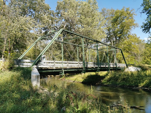
This bridge has been nicely rehabilitated and remains open to traffic today and a good example of a Wrought Iron Bridge Company truss bridge. The bridge was rehabilitated in 1971, and then in 2007 it was extensively rehabilitated. The bridge was fully disassembled for a shop restoration. The bridge is an outstanding example of historic bridge preservation in Ohio.
Information and Findings From Ohio's Historic Bridge InventorySetting/Context The bridge carries a 1 lane road over a stream in a wooded rural setting. Physical Description The 1 span, 108'-long, pin-connected Pratt thru truss bridge is traditionally composed of built-up compression members and eyebar tension members. It has lattice portals. Integrity Rehabilitated in 2007. Truss was relocated off-site to US Bridge to be repaired in-kind and painted, then returned to site. Summary of Significance The 1883 Wrought Iron Bridge Co. pin-connected Pratt thru truss bridge was rehabilitated in 2007. The rehabilitation maintained the integrity of design. The bridge was select in the prior inventory and NR listed in 1990. Justification The bridge is one of over 150 extant pin-connected truss bridges dating from 1874 for pony trusses and 1876 for thru trusses. Twenty six predate 1888 and represent the era of experimentation that evolved into standardized designs by about 1888. This example has a high level of significance based on its early date of construction and association with a prominent builder. Bridge Considered Historic By Survey: Yes |
![]()
![]()
![]()
Coordinates (Latitude, Longitude):
Search For Additional Bridge Listings:
Bridgehunter.com: View listed bridges within 0.5 miles (0.8 kilometers) of this bridge.
Bridgehunter.com: View listed bridges within 10 miles (16 kilometers) of this bridge.
Additional Maps:
Google Streetview (If Available)
GeoHack (Additional Links and Coordinates)
Apple Maps (Via DuckDuckGo Search)
Apple Maps (Apple devices only)
Android: Open Location In Your Map or GPS App
Flickr Gallery (Find Nearby Photos)
Wikimedia Commons (Find Nearby Photos)
Directions Via Sygic For Android
Directions Via Sygic For iOS and Android Dolphin Browser
USGS National Map (United States Only)
Historical USGS Topo Maps (United States Only)
Historic Aerials (United States Only)
CalTopo Maps (United States Only)

© Copyright 2003-2026, HistoricBridges.org. All Rights Reserved. Disclaimer: HistoricBridges.org is a volunteer group of private citizens. HistoricBridges.org is NOT a government agency, does not represent or work with any governmental agencies, nor is it in any way associated with any government agency or any non-profit organization. While we strive for accuracy in our factual content, HistoricBridges.org offers no guarantee of accuracy. Information is provided "as is" without warranty of any kind, either expressed or implied. Information could include technical inaccuracies or errors of omission. Opinions and commentary are the opinions of the respective HistoricBridges.org member who made them and do not necessarily represent the views of anyone else, including any outside photographers whose images may appear on the page in which the commentary appears. HistoricBridges.org does not bear any responsibility for any consequences resulting from the use of this or any other HistoricBridges.org information. Owners and users of bridges have the responsibility of correctly following all applicable laws, rules, and regulations, regardless of any HistoricBridges.org information.
![]()