

View Information About HSR Ratings
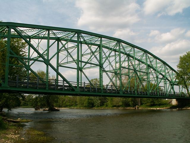
Built 1923-1924 over Great Miami River, this bridge once served an old alignment of Rip Rap Road, which crossed this bridge, continued south, and apparently crossed the river again on what was in 2006 a modern galvanized Bailey truss bridge. Rip Rap Road was realigned in 2002 and now it runs along the east side of the river, bypassing this bridge and the Bailey truss. This bridge's tall trusses and long span make it a stunning example of the complex Pennsylvania truss configuration. Characteristic of bridges built in the later portions of the truss bridge era, the members are fairly massive, and the connections are riveted. There is extensive v-lacing and lattice on the structure, which sits on concrete abutments. There are roller bearings present at the west end of the structure.
This bridge however has been beautifully rehabilitated for non-motorized traffic, and it now serves as part of the Great Miami Recreation Trail that runs along Rip Rap Road north of the bridge. In 2006 the path ended at the bridge, so the bridge was more of an attraction of the path rather than a connection. Apparently the bridge was rehabilitated at the time mainly because of the way that the funding was provided for making the Rip Rap Road recreation trail, and as of 2006 there were currently no plans to extend the trail beyond the bridge. As of 2020, no changes have taken place either. Regardless, the bridge is a significant historic bridge that could provide for the expansion of the trail, and in either case is a major historic attraction that is a destination in itself.
It is a very postive outcome that the bridge is preserved, even if it seems odd that they would restore it if they did not intend to continue the trail over to the other side. It is a rare chance to see a bridge with historic and aesthetic value being restored just for the sake of preserving the bridge, even if it doesn't serve a purpose (although the bridge does serve the purpose of offering views of the river). The bridge itself is a purpose to preserve it, and it appears that the folks who manage the trail funding agreed.
Photos from an older Historic Bridge Inventory show that this bridge had hub guard style lattice railings. These are not present on the bridge today. It is unclear why they were removed. When preserving a historic bridge, adding modern railings to protect the truss or meet pedestrian safety needs is acceptable. However, the original railings should always be left in place behind the added railings. There is no reason to remove them, and removing them reduces the historic integrity of the bridge.
Information and Findings From Ohio's Historic Bridge InventorySetting/Context The bridge carries a bike path over a stream in a wooded setting. Physical Description The 1 span, 300'-long, rivet-connected Pennsylvania thru truss bridge is composed of built-up members. Integrity Bypassed and rehabilitated for bike path use in 2002. Replaced floorbeams, stringer, deck, railings, and minor repairs to trusses. Abutments replaced and bridge deck-level raised several feet. Summary of Significance The 1923 rivet-connected Pennsylvania thru truss bridge is a long-span example of its type/design that was rehabilitated without adverse effect (SHPO letter 1994). It is eligible from the prior ODOT inventory.
Justification The bridge is one of over 40 extant riveted thru truss bridges of all designs built between 1904 and 1959. This example is representative of the population and has moderate significance. There are also many riveted thru truss bridges servicing the many rail lines in the state. Bridge Considered Historic By Survey: Yes |
![]()
![]()
![]()
Coordinates (Latitude, Longitude):
Search For Additional Bridge Listings:
Bridgehunter.com: View listed bridges within 0.5 miles (0.8 kilometers) of this bridge.
Bridgehunter.com: View listed bridges within 10 miles (16 kilometers) of this bridge.
Additional Maps:
Google Streetview (If Available)
GeoHack (Additional Links and Coordinates)
Apple Maps (Via DuckDuckGo Search)
Apple Maps (Apple devices only)
Android: Open Location In Your Map or GPS App
Flickr Gallery (Find Nearby Photos)
Wikimedia Commons (Find Nearby Photos)
Directions Via Sygic For Android
Directions Via Sygic For iOS and Android Dolphin Browser
USGS National Map (United States Only)
Historical USGS Topo Maps (United States Only)
Historic Aerials (United States Only)
CalTopo Maps (United States Only)

© Copyright 2003-2026, HistoricBridges.org. All Rights Reserved. Disclaimer: HistoricBridges.org is a volunteer group of private citizens. HistoricBridges.org is NOT a government agency, does not represent or work with any governmental agencies, nor is it in any way associated with any government agency or any non-profit organization. While we strive for accuracy in our factual content, HistoricBridges.org offers no guarantee of accuracy. Information is provided "as is" without warranty of any kind, either expressed or implied. Information could include technical inaccuracies or errors of omission. Opinions and commentary are the opinions of the respective HistoricBridges.org member who made them and do not necessarily represent the views of anyone else, including any outside photographers whose images may appear on the page in which the commentary appears. HistoricBridges.org does not bear any responsibility for any consequences resulting from the use of this or any other HistoricBridges.org information. Owners and users of bridges have the responsibility of correctly following all applicable laws, rules, and regulations, regardless of any HistoricBridges.org information.
![]()