


View Information About HSR Ratings

This bridge was an uncommon example of a continuous deck truss bridge. The center truss span was all-rigid, while the end truss spans were cantilever arms. Steel stringer approach spans rested on these cantilevered arms. It was not an early example, but given the rarity of these bridges (which is increasing due to demolition) the bridge definitely bears mention.
This bridge was demolished and replaced in 2015 for reasons which are clear as mud. Even the National Bridge Inventory report does not show any problems with the bridge which looked to be in great shape. This is a bridge that at most just needed some minor rehabilitation and maintenance. The next time you are dodging potholes on a road remember this bridge. Wasting money on the replacement of a bridge like this which could otherwise be used to fix things like potholes would be smarter. It would also have preserved this historic bridge.
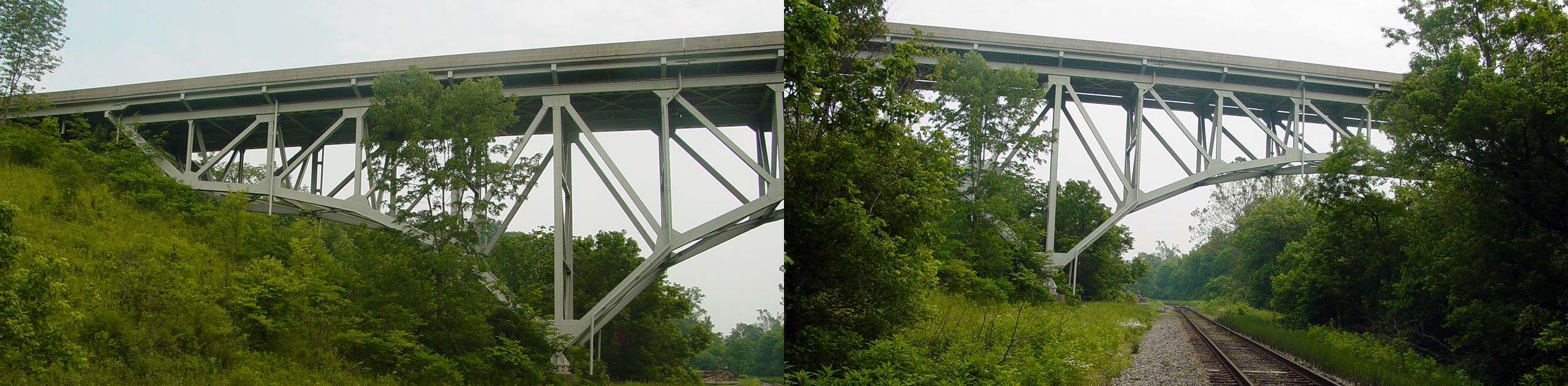
Information and Findings From Ohio's Historic Bridge InventorySetting/Context The bridge carries a 2 lane road over a stream and the former New York Central RR in a rural setting between the villages of West Rushville and Rushville. The bridge was placed on a new alignment that bypasses the town centers of both villages. Physical Description The 3 span, 515'-long, riveted, continuous Pratt deck truss bridge with cantilevered arms is composed of 110' cantilever arms anchored by the 220' long main span with 36' long, simply supported rolled stringer end sections. The stringers at each end of the bridge bear on sliding plates atop the transverse beam connecting to end of the cantilevered chords and on rocker bearings atop stub abutments at the other end of stringer. There are deflection joints where the stringers meet the truss lines. This unusual design was driven by the substrate and the desire to construct the truss superstructure with no rock excavation and to found the east end of the bridge on sound shale. The truss lines are deepest at the pier bearings (a roller bearing exists on the west end and a bolster bearing on the east end), and the cantilevered arms have unsupported ends. Each truss panel is 22' long for 440' long truss lines. The truss members are riveted, built up box sections for the chords, and rolled sections for the diagonals and verticals. The west pier, adjacent to the railroad, is founded on steel piles (for scour protection) driven through silt and clay to refusal (rock) while the east pier footing is founded directly on rock. The original concrete base and tubular aluminum handrail railings have been removed and replaced with safety shape barriers. Otherwise, the bridge appears to be complete. Summary of Significance The design of the 1959, 3 span, continuous Pratt deck truss bridge with cantilevered end spans was developed in response to site conditions and the substrate. The decision was made to limit excavation of the rock slope on the east side and to bring the founding of the east end back to solid shale. This drove the design with the unusual 36' long stringer ends supported by the cantilevered arms and stub abutments. Use of the continuous deck truss design meant that the cantilevered truss arms did not have to be supported at the ends. The 36' long stringers are used to span the difference between the end of the cantilevered truss arms and the desired end of the span on the east, which was determined by the soundness of the substrate. The tapered shape of the cantilever arms corresponds to the original rock slope profile of the east side. The west side had no such rock slope, so a great deal of fill was used to match the elevation of the east end. Although the design is not common, it is not historically or technologically significant. It employs engineering principles that had been known for decades. The continuous design, where the trusses are deepest over the pier bearings, since the stresses are the greatest at those points, together with the tapered cantilevered ends is a more economical use of material. The bridge can be erected without false work and is rigid under traffic. Three span continuous designs, like the Little Rush Creek bridge, proved to be the most common arrangement as after three spans, joints to accommodate expansion and contraction are needed. Bridge Considered Historic By Survey: No |
![]()
![]()
![]()
This historic bridge has been demolished. This map is shown for reference purposes only.
Coordinates (Latitude, Longitude):
Search For Additional Bridge Listings:
Bridgehunter.com: View listed bridges within 0.5 miles (0.8 kilometers) of this bridge.
Bridgehunter.com: View listed bridges within 10 miles (16 kilometers) of this bridge.
Additional Maps:
Google Streetview (If Available)
GeoHack (Additional Links and Coordinates)
Apple Maps (Via DuckDuckGo Search)
Apple Maps (Apple devices only)
Android: Open Location In Your Map or GPS App
Flickr Gallery (Find Nearby Photos)
Wikimedia Commons (Find Nearby Photos)
Directions Via Sygic For Android
Directions Via Sygic For iOS and Android Dolphin Browser
USGS National Map (United States Only)
Historical USGS Topo Maps (United States Only)
Historic Aerials (United States Only)
CalTopo Maps (United States Only)

© Copyright 2003-2026, HistoricBridges.org. All Rights Reserved. Disclaimer: HistoricBridges.org is a volunteer group of private citizens. HistoricBridges.org is NOT a government agency, does not represent or work with any governmental agencies, nor is it in any way associated with any government agency or any non-profit organization. While we strive for accuracy in our factual content, HistoricBridges.org offers no guarantee of accuracy. Information is provided "as is" without warranty of any kind, either expressed or implied. Information could include technical inaccuracies or errors of omission. Opinions and commentary are the opinions of the respective HistoricBridges.org member who made them and do not necessarily represent the views of anyone else, including any outside photographers whose images may appear on the page in which the commentary appears. HistoricBridges.org does not bear any responsibility for any consequences resulting from the use of this or any other HistoricBridges.org information. Owners and users of bridges have the responsibility of correctly following all applicable laws, rules, and regulations, regardless of any HistoricBridges.org information.
![]()