We Recommend:
Bach Steel - Experts at historic truss bridge restoration.
BridgeHunter.com Phase 1 is released to the public! - Visit Now
Shaffer Road Bridge

Primary Photographer(s): Nathan Holth
Bridge Documented: June 30, 2006
Rural: Ashtabula County, Ohio: United States
1913 By Builder/Contractor: Massillon Bridge Company of Massillon, Ohio
2001
166.0 Feet (50.6 Meters)
168.0 Feet (51.2 Meters)
16 Feet (4.88 Meters)
1 Main Span(s)
432814

View Information About HSR Ratings
Bridge Documentation
View Archived National Bridge Inventory Report - Has Additional Details and Evaluation
You might notice that a lot of bridges in this area were built in 1913, an example being the Callender Road Bridge. This is due to a really bad flood that occurred in this area in 1913 and washed away some of the bridges requiring that new ones be constructed.
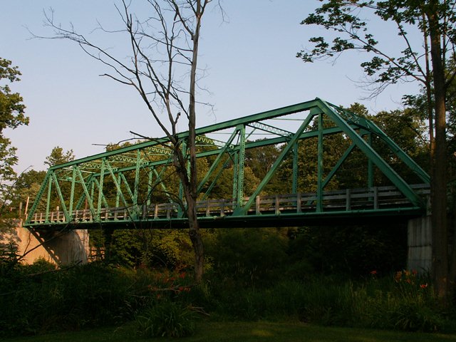
This bridge was built by the Massillon Bridge and Structural Company, which for much of its history was simply called the Massillon Bridge Company. The bridge is an eight panel Pratt through truss bridge with riveted connections. Original railings do not remain on the bridge and modern railings are present on the structure. The portal bracing is a lattice structure, and v-lacing is present on the verticals, sway bracing, and under the top chord / endposts. The bridge is supported by concrete abutments.
This historic bridge has been preserved through a rehabilitation project and remains in good condition today, providing a safe and functional vehicular crossing. Ashtabula County now needs to continue this trend and preserve more of its metal truss bridges, instead of demolishing them like they are currently planning. The fact that this bridge was rehabilitated proves that they can do it to the other bridges.
Information and Findings From Ohio's Historic Bridge InventorySetting/Context The bridge carries a 1 lane road over a stream in a sparsely developed, rural setting. Physical Description The 1 span, 168'-long rivet-connected Pratt thru truss bridge is supported on concrete abutments. It is traditionally composed of built-up members with toe-out channels with cover plate and lacing for the chords and end posts; back-to-back angles with lacing or channels for the verticals and diagonals; and back-to-back angles with battens for the lower chords. The bridge has lattice portals with builders plaque. Integrity Rehabilitated in 2000. Fiberglass deck; strengthening of some members (e.g. adding angle section to lower chords); and some replacement of rivets with high-strength bolts. Summary of Significance The 1913 rivet-connected Pratt thru truss bridge is one of four extant examples of the design in the county that were placed to replace ones lost in a flood. All were placed in 1913, which makes them among the
earliest in the state. Why there are so few riveted through truss bridges in Ohio, when the technology to do field riveting was common by 1900, is not known. The four in the county are determined to be technologically significant
because they are early examples within the Ohio context. It is representative of the standard, riveted, Pratt thru-truss type/design that was popular on Ohio's roads from about 1900 to 1940. The truss superstructure is complete with
the exception of some loss of fabric from corrosion. The Massillon Bridge & Structural Iron Company of Massillon, Ohio, was one of the many Ohio bridge-fabricating companies that served the regional market in steel highway bridges
during the early 20th century. Its designs of this period are not distinctive in and of themselves but reflect the increasing standardization of detail that was the hallmark of rivet-connected highway truss type/design. Justification The bridge is one of over 40 extant riveted thru truss bridges of all designs built between 1904 and 1959. This example is representative of the population and has moderate significance. There are also many riveted thru truss bridges servicing the many rail lines in the state. Bridge Considered Historic By Survey: Yes |
![]()
Photo Galleries and Videos: Shaffer Road Bridge
Bridge Photo-Documentation
Original / Full Size PhotosA collection of overview and detail photos. This gallery offers photos in the highest available resolution and file size in a touch-friendly popup viewer.
Alternatively, Browse Without Using Viewer
![]()
Bridge Photo-Documentation
Mobile Optimized PhotosA collection of overview and detail photos. This gallery features data-friendly, fast-loading photos in a touch-friendly popup viewer.
Alternatively, Browse Without Using Viewer
![]()
Maps and Links: Shaffer Road Bridge
Coordinates (Latitude, Longitude):
Search For Additional Bridge Listings:
Bridgehunter.com: View listed bridges within 0.5 miles (0.8 kilometers) of this bridge.
Bridgehunter.com: View listed bridges within 10 miles (16 kilometers) of this bridge.
Additional Maps:
Google Streetview (If Available)
GeoHack (Additional Links and Coordinates)
Apple Maps (Via DuckDuckGo Search)
Apple Maps (Apple devices only)
Android: Open Location In Your Map or GPS App
Flickr Gallery (Find Nearby Photos)
Wikimedia Commons (Find Nearby Photos)
Directions Via Sygic For Android
Directions Via Sygic For iOS and Android Dolphin Browser
USGS National Map (United States Only)
Historical USGS Topo Maps (United States Only)
Historic Aerials (United States Only)
CalTopo Maps (United States Only)

