

View Information About HSR Ratings
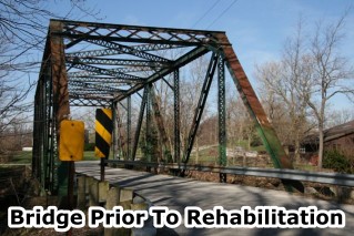
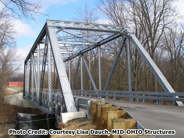
This bridge is a traditional 1920s through truss. It retains good historic integrity aside from missing original railings. Prior to 2012, the bridge was in poor shape, and the need to rehabilitate this historic bridge was apparent. There was section loss in some places on the bridge. The most easily noticeable trouble area was v-lacing on the end post that had suffered severe loss of section. Despite these conditions, the bridge could still be rehabilitated. Given the rapid rate of truss bridge demolition in Ohio, even bridges like this 1920s structure are rapidly becoming rare, and will continue to do so until Ohio realizes a comprehensive historic bridge preservation plan is needed in the state.
Fortunately, Huron County recognized that the solution to improving infrastructure, saving money, and preserving history all have a common solution and in 2012 chose to comprehensively rehabilitate this historic bridge. MID-OHIO Structures completed the rehabilitation which included galvanizing the trusses to protect them from corrosion. New guardrails replacing the previous non-original guardrail on the bridge protect the trusses from vehicular collision.
Information and Findings From Ohio's Historic Bridge InventorySetting/Context The bridge carries a 2 lane road over a stream in a sparsely developed, rural setting. Physical Description The 1 span, 128'-long, rivet-connected Warren with verticals thru truss bridge is traditionally composed of built-up members. It has beam guide rails replacing original lattice railings and steel deck pan that were placed as part of a rehabilitation project in 1994. Integrity Replacement railings (1994). Summary of Significance The 1926 rivet-connected Warren thru truss bridge is a late example of its type/design with no distinguishing features or details. Warren trusses are the most common design found in Ohio and the nation. The Ohio
Phase 1A survey (2008) has identified more than 500 examples dating from 1897 to 1961, accounting for well over half of the approximately 800 pre-1961 metal trusses. The Warren design was particularly well suited to rigid (riveted,
and later welded connections), but not as well suited to pin connections; this helps to explain its popularity in the 20th century rather than the 19th century, although it is based on a British patent issued to engineers James
Warren and Willoughby Monzani in 1848. In the U.S., the popularity of the Warren truss coincided with improvements in pneumatic field riveting equipment starting about 1900. The Warren, which is based on a series of equilateral
triangles, is identified by its simplicity of design, ease of construction with equal-sized members, and ability of some diagonals to act in both tensions and compression. Warren trusses are often stiffened by the addition of
verticals; they can also have polygonal (sloped) upper chords to achieve greatest depth at midspan. Bridge Considered Historic By Survey: No |
![]()
![]()
![]()
Coordinates (Latitude, Longitude):
Search For Additional Bridge Listings:
Bridgehunter.com: View listed bridges within 0.5 miles (0.8 kilometers) of this bridge.
Bridgehunter.com: View listed bridges within 10 miles (16 kilometers) of this bridge.
Additional Maps:
Google Streetview (If Available)
GeoHack (Additional Links and Coordinates)
Apple Maps (Via DuckDuckGo Search)
Apple Maps (Apple devices only)
Android: Open Location In Your Map or GPS App
Flickr Gallery (Find Nearby Photos)
Wikimedia Commons (Find Nearby Photos)
Directions Via Sygic For Android
Directions Via Sygic For iOS and Android Dolphin Browser
USGS National Map (United States Only)
Historical USGS Topo Maps (United States Only)
Historic Aerials (United States Only)
CalTopo Maps (United States Only)

© Copyright 2003-2026, HistoricBridges.org. All Rights Reserved. Disclaimer: HistoricBridges.org is a volunteer group of private citizens. HistoricBridges.org is NOT a government agency, does not represent or work with any governmental agencies, nor is it in any way associated with any government agency or any non-profit organization. While we strive for accuracy in our factual content, HistoricBridges.org offers no guarantee of accuracy. Information is provided "as is" without warranty of any kind, either expressed or implied. Information could include technical inaccuracies or errors of omission. Opinions and commentary are the opinions of the respective HistoricBridges.org member who made them and do not necessarily represent the views of anyone else, including any outside photographers whose images may appear on the page in which the commentary appears. HistoricBridges.org does not bear any responsibility for any consequences resulting from the use of this or any other HistoricBridges.org information. Owners and users of bridges have the responsibility of correctly following all applicable laws, rules, and regulations, regardless of any HistoricBridges.org information.
![]()