We Recommend:
Bach Steel - Experts at historic truss bridge restoration.
BridgeHunter.com Phase 1 is released to the public! - Visit Now
Willey Road Bridge

Primary Photographer(s): Nathan Holth
Bridge Documented: September 22, 2019
Rural: Hamilton County, Ohio: United States
1996
62.0 Feet (18.9 Meters)
65.0 Feet (19.8 Meters)
27 Feet (8.23 Meters)
1 Main Span(s)
3130622

View Information About HSR Ratings
Bridge Documentation
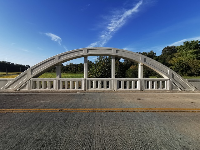
This is one of a small number of surviving rainbow arch bridges in Ohio. This bridge was altered in 1996 when it was essentially replaced with a pre-stressed concrete bridge. The original arches were retained on the replacement bridge as non-functional decorations. Despite the alteration, this bridge is (surprisingly) still considered eligible for listing in the National Register of Historic Places. The Historic Bridge Inventory claims this bridge was built in 1911 and designed by E. A. Gast, around the same time as the Benson Street Bridge also designed by E. A. Gast. However, the given National Bridge Inventory date is 1931, and visually, the bridge looks more like 1930s arches in Ohio. It is not known what information the Historic Bridge Inventory used to get the 1911 date, thus the accuracy of it is in question.
View Archived National Bridge Inventory Report - Has Additional Details and Evaluation
Information and Findings From Ohio's Historic Bridge InventorySetting/Context The bridge carries a 2 lane road over a stream in a rural setting with scattered 20th century residences. Physical Description The 1 span, 65'-long, reinforced concrete thru arch bridge has paneled arch ribs, paneled hangers, and concrete balustrades. The floorbeams and deck were replaced in 1996 with prestressed concrete box beams that are now load carrying. The arches do not carry live loads. The bridge has paneled U-shaped wingwalls that are finished with paneled parapets. Designer: E.A. Gast, Hugo Eichler Integrity Floorbeams and deck replaced with prestressed concrete box beams in 1996. Summary of Significance The 1911 thru (or rainbow) arch bridge has been altered by replacing the floorbeam/deck system and relieving the arches of live loads, but the appearance of the bridge has been maintained from both elevations and the fabric of the arches, hangers, and railings repaired in-kind. This is among the oldest of seven rainbow arches in the state dating from 1909 to 1930. It is an early and technologically significant example of its type/design and it retains sufficient integrity of design/materials to conveys its significance. The rainbow arch in the U.S. developed in the late 1900s and early 1910s, with its best known variation the 1912 patented design of James B. Marsh of Iowa, (which is debatably a steel arch encased in concrete). In the basic design the deck is supported by vertical hangers between the arch ribs and the floorbeams. The arch ribs, like Marsh's can have patented steel systems within them, or they can be un-patented systems of conventional reinforced concrete. The bridge type/design is known to be aesthetically pleasing and came to be popularly known as "rainbow" arches in some parts of the country, including Ohio, although technically they are perhaps best described as thru arches. The bridge type was always more numerous in the Midwest than other parts of the U.S., probably because of the influence of Marsh. The 1909 and 1911 thru arches designed by E. A. Gast in Hamilton County (3137600 & 3130622) are Ohio's oldest examples and very technologically significant as they predate the Marsh patent and are believed to have been developed independently. Later examples in Ohio are most often the design of the state bridge bureau, which developed its own standard rainbow arch by 1923. Justification The bridge is one of 5 remaining examples of the type that was once not uncommon in Ohio. It offered an aesthetic treatment preferred in urban and picturesque settings. The 6 examples date from 1909 to 1930, and each is of high significance given their limited numbers and importance within the context as the aesthetic alternative to the thru truss bridge. Bridge Considered Historic By Survey: Yes |
![]()
Photo Galleries and Videos: Willey Road Bridge
Bridge Photo-Documentation
Original / Full Size PhotosA collection of overview and detail photos. This gallery offers photos in the highest available resolution and file size in a touch-friendly popup viewer.
Alternatively, Browse Without Using Viewer
![]()
Bridge Photo-Documentation
Mobile Optimized PhotosA collection of overview and detail photos. This gallery features data-friendly, fast-loading photos in a touch-friendly popup viewer.
Alternatively, Browse Without Using Viewer
![]()
Maps and Links: Willey Road Bridge
Coordinates (Latitude, Longitude):
Search For Additional Bridge Listings:
Bridgehunter.com: View listed bridges within 0.5 miles (0.8 kilometers) of this bridge.
Bridgehunter.com: View listed bridges within 10 miles (16 kilometers) of this bridge.
Additional Maps:
Google Streetview (If Available)
GeoHack (Additional Links and Coordinates)
Apple Maps (Via DuckDuckGo Search)
Apple Maps (Apple devices only)
Android: Open Location In Your Map or GPS App
Flickr Gallery (Find Nearby Photos)
Wikimedia Commons (Find Nearby Photos)
Directions Via Sygic For Android
Directions Via Sygic For iOS and Android Dolphin Browser
USGS National Map (United States Only)
Historical USGS Topo Maps (United States Only)
Historic Aerials (United States Only)
CalTopo Maps (United States Only)

