We Recommend:
Bach Steel - Experts at historic truss bridge restoration.
BridgeHunter.com Phase 1 is released to the public! - Visit Now
Youngs Bridge
Old OH-73 Bridge

Primary Photographer(s): Nathan Holth and Rick McOmber
Bridge Documented: June 7, 2014
Not Available or Not Applicable
49.0 Feet (14.9 Meters)
51.0 Feet (15.5 Meters)
15.4 Feet (4.69 Meters)
1 Main Span(s)
7332785

View Information About HSR Ratings
Bridge Documentation
This bridge's future is at risk!
Bridge Status: This historic bridge is slated for demolition and replacement in 2015!View Archived National Bridge Inventory Report - Has Additional Details and Evaluation
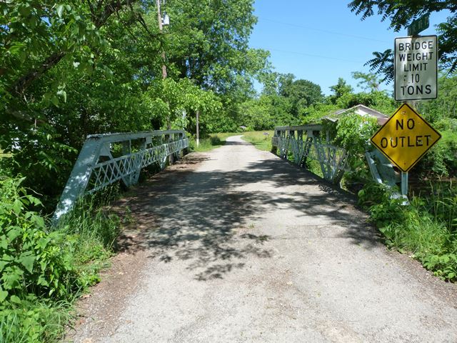
This may not be the rarest or most significant of truss bridges, but it is a nice looking and unaltered representative example of a rivet-connected pony truss. Sadly, this was not enough to spare the bridge from demolition and replacement. The bridge is on a dead-end road which is an old state highway alignment.
The planned demolition and replacement of this bridge explains simultaneously why historic bridges are disappearing and also why you hear about "our nation's crumbling infrastructure" on the news. While lawmakers and the media would have you believe that there is a shortage of available money, the reality is there is plenty of money, but its being spent unwisely. Bridges are not being maintained, leading to costly replacement projects. Also, bridges like this one which don't need to be replaced are being replaced at high cost to taxpayers. Sadly, many of these needless replacements involve historic bridges, which is why this also explains the loss of historic bridges to some extent. This bridge in 2014 served only a couple houses on a dead-end road. It was in decent condition and had a 10 ton weight limit. The reasonable weight limit, use of the bridge by only a couple homes, and decent bridge condition all suggest that the bridge could have been repaired for lesser cost instead of being replaced.
One amusing aspect of this bridge is the Average Daily Traffic listing of 89. A pair of large college fraternity houses probably wouldn't put that much traffic on a bridge, let alone a couple rural homes, unless the homeowners are paid to drive back and forth over the bridge all day. This is also genuinely concerning, since it is unclear what effect an unrealistic ADT might have on decisions to spend money demolishing and replacing the bridge.
![]()
Photo Galleries and Videos: Youngs Bridge
Bridge Photo-Documentation
Original / Full Size PhotosA collection of overview and detail photos. This gallery offers photos in the highest available resolution and file size in a touch-friendly popup viewer.
Alternatively, Browse Without Using Viewer
![]()
Bridge Photo-Documentation
Mobile Optimized PhotosA collection of overview and detail photos. This gallery features data-friendly, fast-loading photos in a touch-friendly popup viewer.
Alternatively, Browse Without Using Viewer
![]()
Maps and Links: Youngs Bridge
Coordinates (Latitude, Longitude):
Search For Additional Bridge Listings:
Bridgehunter.com: View listed bridges within 0.5 miles (0.8 kilometers) of this bridge.
Bridgehunter.com: View listed bridges within 10 miles (16 kilometers) of this bridge.
Additional Maps:
Google Streetview (If Available)
GeoHack (Additional Links and Coordinates)
Apple Maps (Via DuckDuckGo Search)
Apple Maps (Apple devices only)
Android: Open Location In Your Map or GPS App
Flickr Gallery (Find Nearby Photos)
Wikimedia Commons (Find Nearby Photos)
Directions Via Sygic For Android
Directions Via Sygic For iOS and Android Dolphin Browser
USGS National Map (United States Only)
Historical USGS Topo Maps (United States Only)
Historic Aerials (United States Only)
CalTopo Maps (United States Only)

