

View Information About HSR Ratings
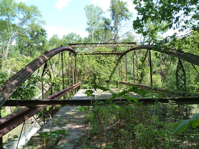
This bridge is a rare bowstring truss bridge, that has been long bypassed and abandoned. It is a traditional example of the Wrought Iron Bridge Company design of bowstring, which as usual, includes a keystone column top chord. With a given 1873 construction date, it is a very old surviving example of this design. Despite its state of abandonment, this bridge could and should be restored. Relocated, it would make a great addition to a non-motorized pathway. Any restoration done on this bridge however should be carefully executed so as to not alter the original materials and design of the bridge. Failed rivets should be replaced with rivets, not high-strength bolts. Built-up beams with too much section loss and pack rust should be replicated as built-up beams. Bridges of this type are among the rarest type of metal truss bridge in the country. Each surviving example is significant and should not only receive high priority for preservation, but any preservation project carried out should be of the highest quality.
Local historian and preservationist Jess Lamar Reece Holler contacted HistoricBridges.org in October 2022 with a wealth of information about the bridge:
The Caledonia Bowstring Bridge is not original to Caledonia. Like many bridges of its kind it was relocated and reused when it became insufficient for its original location. The bridge was previously located in Espyville: a (since vanished) railroad town in western Marion County. The bridge was moved to Caledonia in 1978 after a concerted effort by local preservationists: including Trella Romine, a founder of the Marion County Historical Society, who lived along the Whetstone River outside of Caledonia. The move was a part of a visionary plan to rehabilitate the bridge and to develop a 35-acre village park on the other side of the river, which was otherwise inaccessible. The campaign was enormously successful, and a team of locals, including the Marion County Historical Society, Caledonia Village Council, Claridon County Commissioners, & Marion City & County Regional Planning Commission, won millions in grants for the project in the early 1980s. However, due to a technicality, the state would not deliver the funding. The team was heartbroken and disillusioned, and the bridge has sat overgrown at its location on Caledonia-Northern Road ever since. As of 2022, there is a renewed effort to seek grants to restore this bridge.
Information and Findings From Ohio's Historic Bridge InventorySetting/Context The bridge is on an abandoned road off of CR 194 north of Caledonia. It is closed to traffic and overgrown, but the bridge is readily accessible. Physical Description The 1 span, bowstring thru truss bridge has tubular arch chords composed of Phoenix sections. The verticals are built up and the diagonals are rods with upturned ends. The bridge is supported on caissons. The bridge appears to be complete albeit deteriorated. Lateral and sway bracing is in place as are cruciform-shape outriggers. Integrity Appears to have integrity despite deterioration. Summary of Significance The Wrought Iron Bridge Co. bowstring truss was fabricated in 1873 and is a complete example of a rare patented bridge type/design by a prominent Ohio fabricator. It was NR listed in 1978. Justification The bridge is one of the 22 extant bowstring truss bridges that survive in the state. Having so many is remarkable, and even though they are "common" based on their numbers, each is an important and irreplaceable record of the development of the metal truss bridge and the ingenuity associated with the Ohio industrial development. The bridge has high significance. Bridge Considered Historic By Survey: Yes |
This bridge is tagged with the following special condition(s): Keystone Columns
![]()
![]()
![]()
Coordinates (Latitude, Longitude):
Search For Additional Bridge Listings:
Bridgehunter.com: View listed bridges within 0.5 miles (0.8 kilometers) of this bridge.
Bridgehunter.com: View listed bridges within 10 miles (16 kilometers) of this bridge.
Additional Maps:
Google Streetview (If Available)
GeoHack (Additional Links and Coordinates)
Apple Maps (Via DuckDuckGo Search)
Apple Maps (Apple devices only)
Android: Open Location In Your Map or GPS App
Flickr Gallery (Find Nearby Photos)
Wikimedia Commons (Find Nearby Photos)
Directions Via Sygic For Android
Directions Via Sygic For iOS and Android Dolphin Browser
USGS National Map (United States Only)
Historical USGS Topo Maps (United States Only)
Historic Aerials (United States Only)
CalTopo Maps (United States Only)

© Copyright 2003-2025, HistoricBridges.org. All Rights Reserved. Disclaimer: HistoricBridges.org is a volunteer group of private citizens. HistoricBridges.org is NOT a government agency, does not represent or work with any governmental agencies, nor is it in any way associated with any government agency or any non-profit organization. While we strive for accuracy in our factual content, HistoricBridges.org offers no guarantee of accuracy. Information is provided "as is" without warranty of any kind, either expressed or implied. Information could include technical inaccuracies or errors of omission. Opinions and commentary are the opinions of the respective HistoricBridges.org member who made them and do not necessarily represent the views of anyone else, including any outside photographers whose images may appear on the page in which the commentary appears. HistoricBridges.org does not bear any responsibility for any consequences resulting from the use of this or any other HistoricBridges.org information. Owners and users of bridges have the responsibility of correctly following all applicable laws, rules, and regulations, regardless of any HistoricBridges.org information.
![]()