

View Information About HSR Ratings
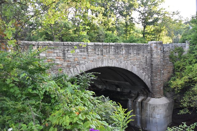
This bridge was designed as a stone faced concrete arch bridge to blend in with its scenic setting.
Information and Findings From Ohio's Historic Bridge InventorySetting/Context The bridge carries a 2-lane state highway over a stream in a mixed use setting in Brecksville. The commercial center of the town is to the west, and the south side of the bridge is in Metroparks Brecksville Reservation. The bridge is at the entrance to the park. Physical Description The 1 span reinforced concrete arch bridge is finished with a rusticated, random ashlar sandstone veneer to the spandrel walls and crenellated parapets, which are accented with refuges. The arch is articulated with staggered voussoirs. The bridge is well proportioned and appears complete save for a massive toe wall placed on the east side. Integrity The large toe wall has been added at the stream on the east side. It is not in keeping with the styling of the bridge. Summary of Significance The handsome reinforced-concrete arch bridge with stone veneer was designed by D. H. Overman, the state bridge bureau's principal design engineer who was noted for his well-executed and proportioned arch designs. The bridge was rehabilitated in 1997 without adverse effect. The eligible recommendation of the prior inventory remains appropriate. Justification The bridge is representative of the fine aesthetic designs produced by the state highway department's bridge division in the 1930s for sensitive settings. There are over 12 examples of the type and design in the state. Bridge Considered Historic By Survey: Yes |
![]()
![]()
![]()
Coordinates (Latitude, Longitude):
Search For Additional Bridge Listings:
Bridgehunter.com: View listed bridges within 0.5 miles (0.8 kilometers) of this bridge.
Bridgehunter.com: View listed bridges within 10 miles (16 kilometers) of this bridge.
Additional Maps:
Google Streetview (If Available)
GeoHack (Additional Links and Coordinates)
Apple Maps (Via DuckDuckGo Search)
Apple Maps (Apple devices only)
Android: Open Location In Your Map or GPS App
Flickr Gallery (Find Nearby Photos)
Wikimedia Commons (Find Nearby Photos)
Directions Via Sygic For Android
Directions Via Sygic For iOS and Android Dolphin Browser
USGS National Map (United States Only)
Historical USGS Topo Maps (United States Only)
Historic Aerials (United States Only)
CalTopo Maps (United States Only)

© Copyright 2003-2025, HistoricBridges.org. All Rights Reserved. Disclaimer: HistoricBridges.org is a volunteer group of private citizens. HistoricBridges.org is NOT a government agency, does not represent or work with any governmental agencies, nor is it in any way associated with any government agency or any non-profit organization. While we strive for accuracy in our factual content, HistoricBridges.org offers no guarantee of accuracy. Information is provided "as is" without warranty of any kind, either expressed or implied. Information could include technical inaccuracies or errors of omission. Opinions and commentary are the opinions of the respective HistoricBridges.org member who made them and do not necessarily represent the views of anyone else, including any outside photographers whose images may appear on the page in which the commentary appears. HistoricBridges.org does not bear any responsibility for any consequences resulting from the use of this or any other HistoricBridges.org information. Owners and users of bridges have the responsibility of correctly following all applicable laws, rules, and regulations, regardless of any HistoricBridges.org information.
![]()