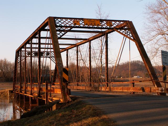
For a pin-connected structure, this traditional truss
bridge is fairly massive in terms of design. It features large built-up
floor beams, relatively wide deck width, and large end post and top chord
size. It is likely a post-1900 truss bridge as a result, perhaps dating to
as late as 1915. A few bridge companies such as the Oregonia Bridge Company
continued to build pin-connected through truss bridges into the early 20th
century, although for the most part pin-connected truss bridges quickly fell
from favor to riveted connections.
The Hayport Road Bridge features seven panels.
Information and Findings From Ohio's Historic Bridge
Inventory
Setting/Context
The bridge carries a 2 lane road over a stream in a rural area of active farms.
Physical Description
The 1 span, 108'-long, pin-connected Pratt thru truss bridge is traditionally composed of built-up compression members and eyebar tension members. It has lattice portal bracing.
Integrity
Replaced deck and stringers in 1982.
Summary of Significance
The ca. 1905 pin-connected Pratt thru truss bridge is later example of a common type/design and has no distinctive details or features. The builder is not documented by available county records. The not eligible
recommendation of the prior inventory remains appropriate.
Pratt trusses were undoubtedly the most popular truss design of the last quarter of the 19th century and continued to be built into the 20th century, although
eventually superseded in popularity by Warren trusses. The design, which initially was a combination of wood compression and iron tension members, was patented in 1844 by Thomas & Caleb Pratt. Ohio has three covered bridges that use
this combination configuration, but they are all modern reconstructions based on the Pratt patent. The great advantage of the Pratt over other designs was the relative ease of calculating the distribution of stresses. More
significantly, it translated well into an all-metal design in lengths of less than 200'. Significant surviving examples of all-metal Pratt trusses mostly date to the last quarter of the 19th century, and they are found with thru,
pony, and the less common bedstead configuration. Prior to about 1890, a variety of panel point connections were in widespread use (including bolts, cast-iron pieces, and pins), but engineering opinion was coalescing around pins as
the most efficient and constructible. Many of the connection details were proprietary and associated with individual builders or companies, and thus earlier examples are generally taken to be technologically significant in showing
the evolution of the design. Later post-1890 Pratt trusses show a progression toward less variation in their details such that by 1900 the design was quite formulaic with few significant differences between the designs of various
builders. This marked the end of the pin-connected Pratt's technological evolution and, in fact, it was soon waning and eclipsed in the highway bridge market by more rigid, rivet-connected truss designs, particularly the Warren but
also riveted Pratts. The transition to riveted connections, which happened even earlier with railroads than highways, was in no small part due to concerns about stress reversals at the pins under heavier loads and improvements in
pneumatic field riveting equipment in the early 1900s. In Ohio, Pratt truss highway bridges, whether pinned or riveted, were almost always built under the auspices of counties and local units of government; the Pratt was not a
standard design of the state highway department.
In Ohio, there are 185 Pratt trusses dating from ca. 1874 to 1945 with at least 60 dating prior to 1900 (Phase 1A, 2008). The technologically significant unaltered examples of
pin-connected Pratt trusses for the most part date prior to 1900 and have documented or attributed builders and dates of construction and/or significant connection or member details. Later post-1900 examples are less technologically
significant. Significant unaltered examples of riveted-connected Pratt trusses date from ca. 1900 to 1915.
A collection of overview and detail photos. This photo gallery contains a combination of Original Size photos and Mobile Optimized photos in a touch-friendly popup viewer. Alternatively, Browse Without Using Viewer
Maps and Links: Hayport Road Bridge
This historic bridge has been demolished. This map is shown for reference purposes only.