

View Information About HSR Ratings
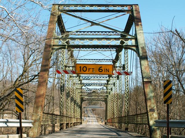
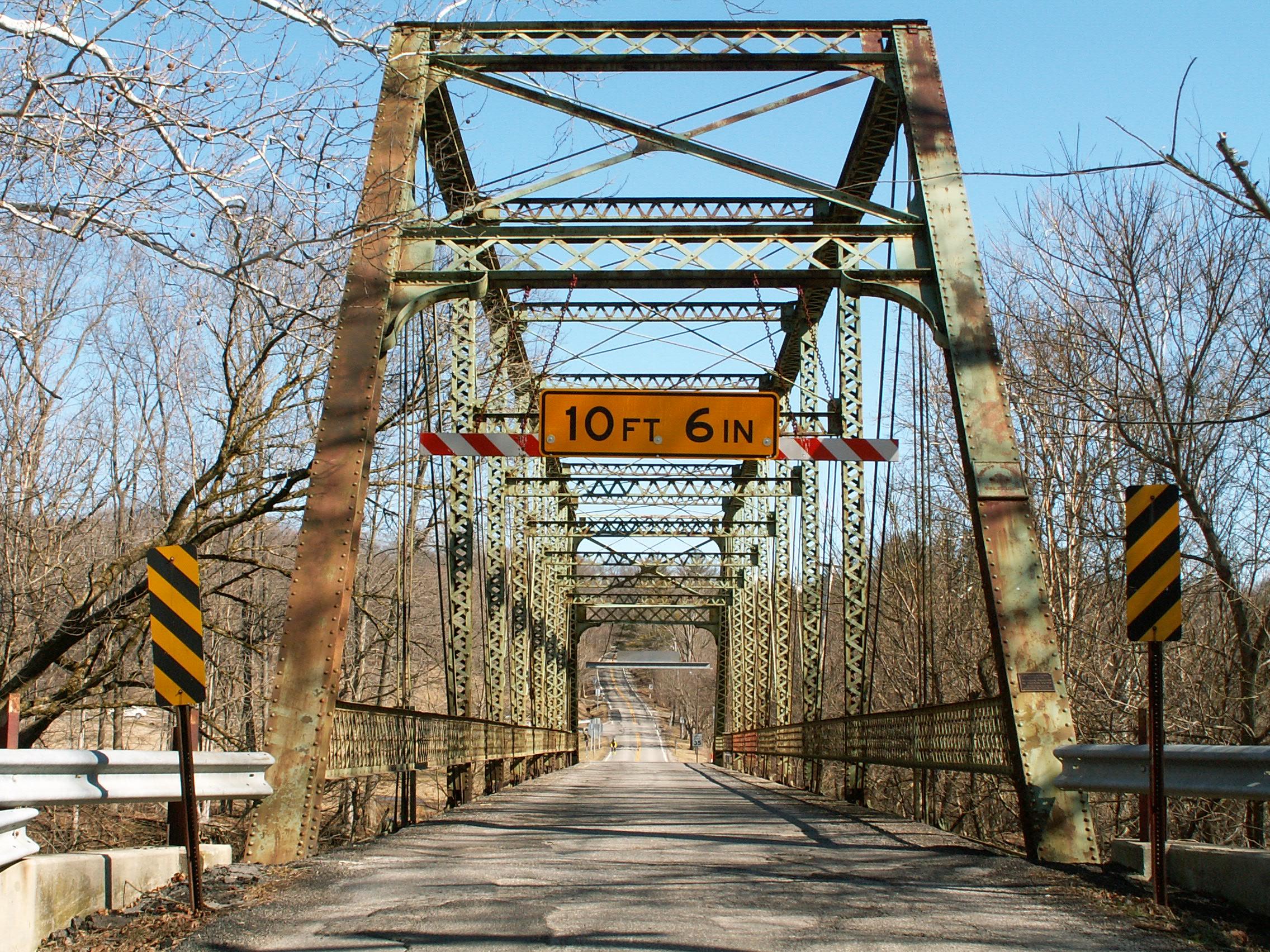
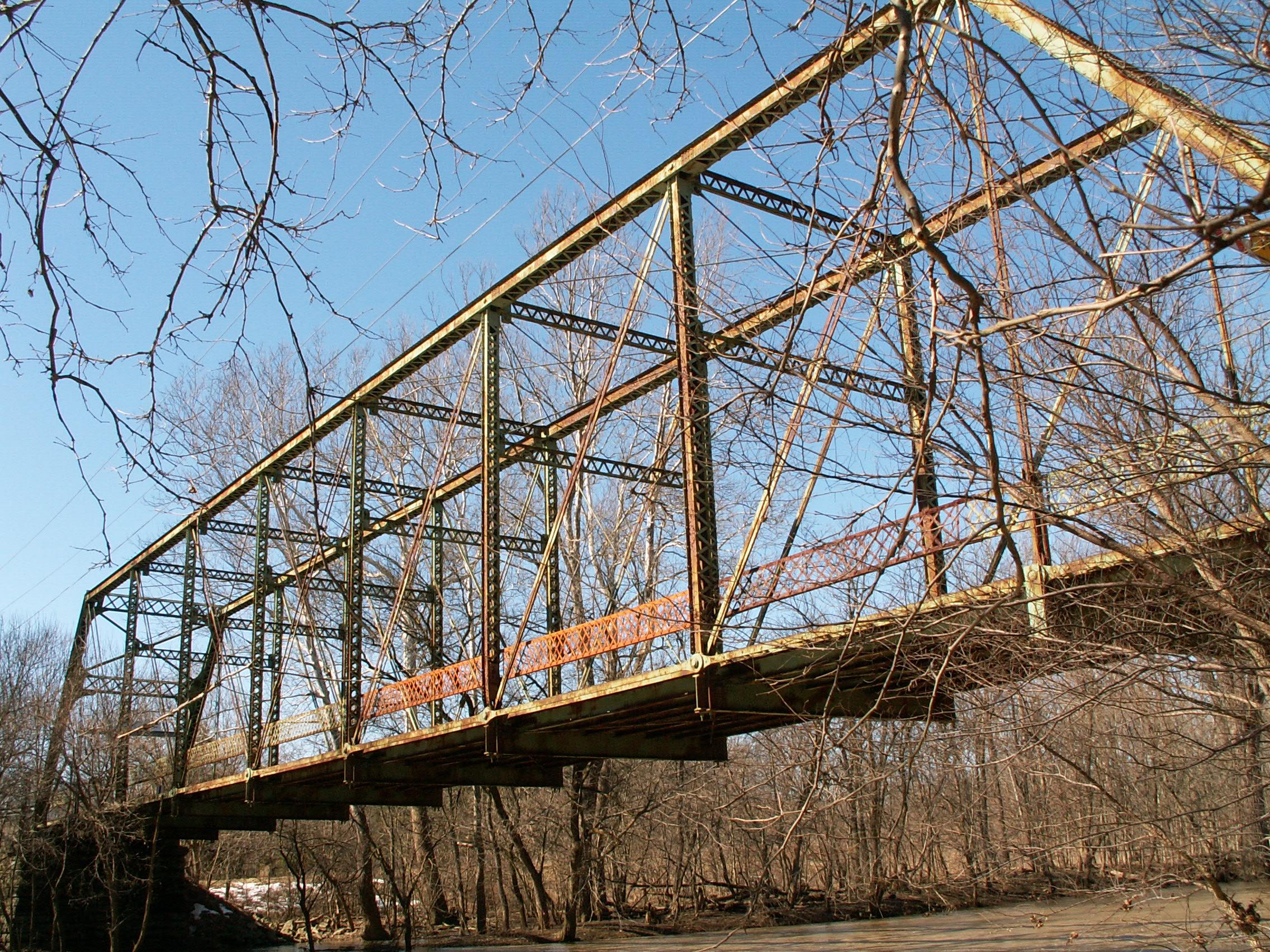
This breathtaking bridge was built in 1898 by the Toledo Bridge Company (which was originally the Smith Bridge Company). Abutments are original stone at the west end of the bridge, while the east end of the bridge has a concrete abutment. The bridge retains a remarkable amount of historic integrity, including original floor beams and lattice railings, as well as builder and commissioner plaques remaining on the bridge. The bridge is a nine panel structure. It features attractive v-lacing on the sway bracing, under the top chord / end post, as well as on the vertical members. Lattice is present on the portal bracing and on the railings.
The Orange Road Bridge is a very long example of a single-span pin-connected Pratt through truss. It is uncommon to find a traditional late 19th century pin-connected Pratt truss at this length. As a function of its length, it features taller, impressive trusses that feature a more complex network of sway bracing that more commonly shows up in Whipple truss which were often more preferred for spans of this length.
The first section of bottom chord (between the end post and the hip vertical) is not the standard eye bar but is instead an unusual built-up beam that has an unusual corrugated form of v-lacing (sometimes called ribbon lacing). Historic bridge expert David Simmons believes that this is due to the unique elevated position of the bridge, relative to the approaching road. He believes that the Toledo Bridge Company did this to add support to the bridge as the angle at which vehicles would enter the bridge would be different due to the elevated position. It should also be noted that railroad bridges sometimes display this detail as well.
Unfortunately, the flooring system (floor beams and deck stringers) on this bridge are in poor condition. This is a typical trouble spot for a truss bridge, however, and is possible to easilly correct through a preservation project. The remainder of the truss superstructure is in good condition however, and would take to a rehabilitation project quite well. The stone abutment at the west end of the bridge has lost much of its mortar, and the stones have begun to separate. Again however, this could be corrected as part of a restoration project.
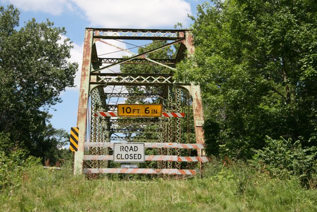
This bridge was bypassed in 2009 by a new bridge on a different alignment. The bridge was left standing next to its replacement, but has remained at risk of demolition. The historic bridge has a lot of support from the community who do not want this beautiful historic bridge reduced to scrap metal, but for whatever reason the Delaware County Engineer does not want to leave the bridge standing where it is, and has threatened to demolish it numerous times. Therefore, for some time now, efforts have been underway to raise money and arrange to relocate and preserve the bridge elsewhere. As of May 2013, the plan was to move the bridge to cross Wildcat Run in Liberty Township Park, located at the southwest corner of Home and Liberty roads. As November 2013, efforts are apparently still underway to raise funds to relocate the bridge. If you are interested in helping save this bridge through a donation, donations can be made to the Liberty Township Foundation Fund's Liberty Bridges Fund.
Until funds are fully secured to relocate the bridge, this historic bridge should be considered to be at risk for demolition.
It is imperative to retain the historic integrity of the bridge. In particular, leaving the original railings on the bridge is of great importance. If modern safety railings are needed, they should produce a minimal visual impact on the bridge and can be placed in front of the original railings without having to remove the original railings. It is also important that a restoration respect the original design of the bridge. If rivets have failed on the bridge, they should be replaced with rivets. There are contractors who have restored bridges and know how to rivet. If the floor beams need to be replaced, they should be replicated. The floor beams on Orange Road Bridge are American Standard Beams, and as such if replaced, they should not be replaced with wide flange beams. American Standard Beams are still manufactured, and are available for bridge restorations.
Information and Findings From Ohio's Historic Bridge InventorySetting/Context The bridge carries a 2 lane road over a stream in a rural setting with scattered 20th century residences. Physical Description The 1 span, 182'-long pin-connected Pratt thru truss bridge is traditionally composed of built-up compression members and eye bar or rod tension members. Due to the length, it has sub-lateral struts and bracing for extra stiffening. Integrity Relocated in 1913. Stringers and deck replaced in 1970. Summary of Significance The 1898 Pratt thru truss bridge is a fine and long-span example of this period type/design. There has been no significant change in the bridge's status since the prior inventory other than it will be closed and
bypassed by a new bridge. The bridge was NR listed in 2002. Justification The bridge is one of over 150 extant pin-connected truss bridges dating from 1874 for pony trusses and 1876 for thru trusses. Twenty six predate 1888 and represent the era of experimentation that evolved into standardized designs by about 1888. This example has moderate significance because the genre and the fabricator are so well represented in Ohio. Bridge Considered Historic By Survey: Yes |
This bridge is tagged with the following special condition(s): Unorganized Photos
![]()
![]()
![]()

![]()
![]()
![]()
Coordinates (Latitude, Longitude):
Search For Additional Bridge Listings:
Bridgehunter.com: View listed bridges within 0.5 miles (0.8 kilometers) of this bridge.
Bridgehunter.com: View listed bridges within 10 miles (16 kilometers) of this bridge.
Additional Maps:
Google Streetview (If Available)
GeoHack (Additional Links and Coordinates)
Apple Maps (Via DuckDuckGo Search)
Apple Maps (Apple devices only)
Android: Open Location In Your Map or GPS App
Flickr Gallery (Find Nearby Photos)
Wikimedia Commons (Find Nearby Photos)
Directions Via Sygic For Android
Directions Via Sygic For iOS and Android Dolphin Browser
USGS National Map (United States Only)
Historical USGS Topo Maps (United States Only)
Historic Aerials (United States Only)
CalTopo Maps (United States Only)

© Copyright 2003-2025, HistoricBridges.org. All Rights Reserved. Disclaimer: HistoricBridges.org is a volunteer group of private citizens. HistoricBridges.org is NOT a government agency, does not represent or work with any governmental agencies, nor is it in any way associated with any government agency or any non-profit organization. While we strive for accuracy in our factual content, HistoricBridges.org offers no guarantee of accuracy. Information is provided "as is" without warranty of any kind, either expressed or implied. Information could include technical inaccuracies or errors of omission. Opinions and commentary are the opinions of the respective HistoricBridges.org member who made them and do not necessarily represent the views of anyone else, including any outside photographers whose images may appear on the page in which the commentary appears. HistoricBridges.org does not bear any responsibility for any consequences resulting from the use of this or any other HistoricBridges.org information. Owners and users of bridges have the responsibility of correctly following all applicable laws, rules, and regulations, regardless of any HistoricBridges.org information.
![]()