


View Information About HSR Ratings
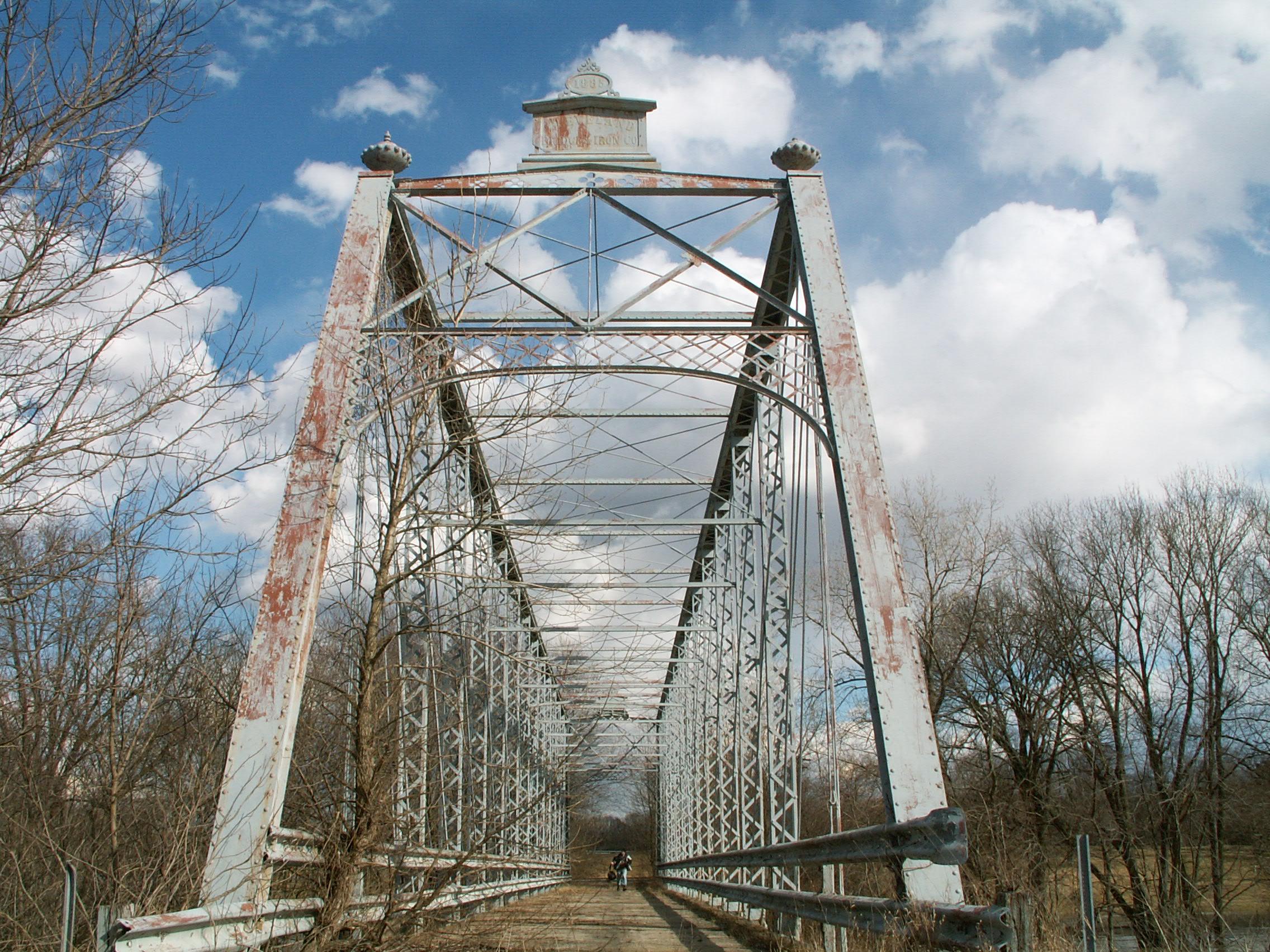
This bridge is a glorious structure and has stood for well over a century as a testimony to the skills of the Cleveland Bridge and Iron Company. It is a very ornate bridge, featuring large, decorative finials on top of the portal at the end posts. The builder plaques that remain on the bridge are also large and highly decorative in design. The portal bracing itself has a great deal of design as well featuring an arch shape at the bottom, and a design on the top that features patterns of circles in a cloverleaf-like fashion.
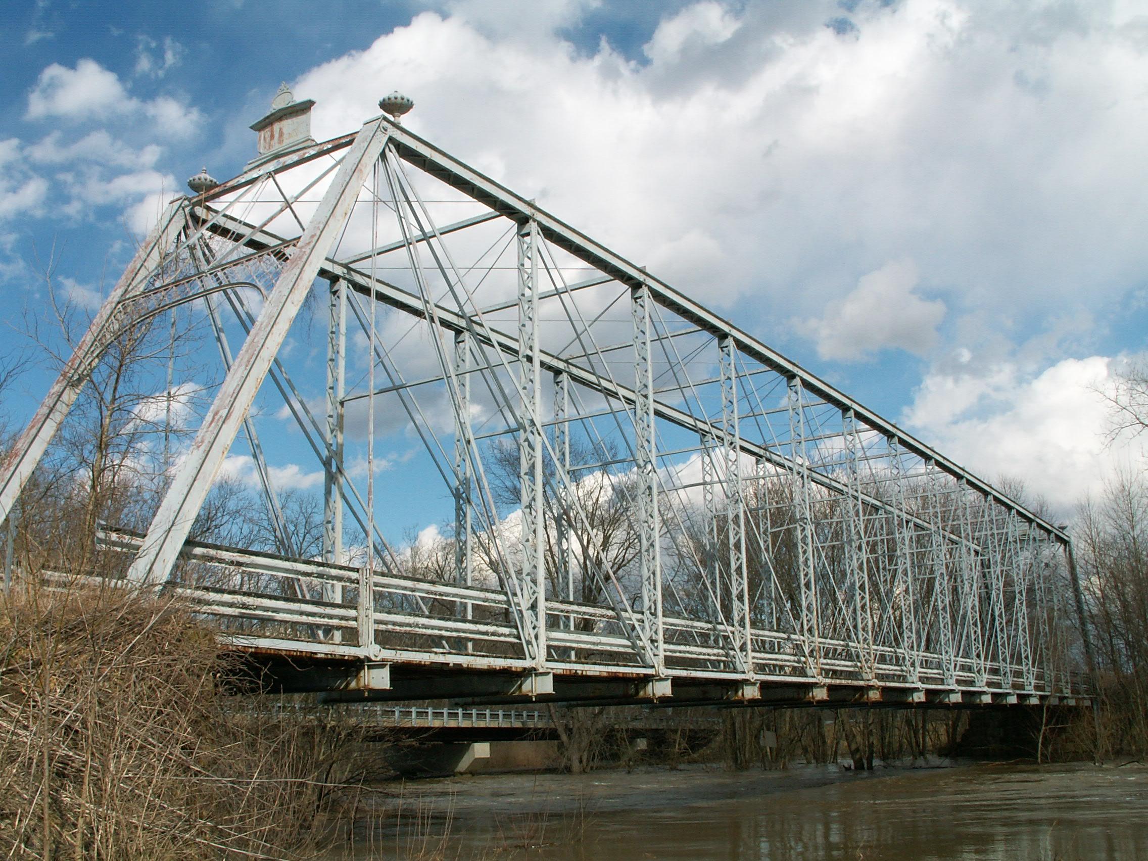
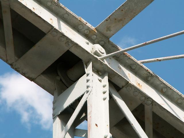
The bridge itself is a very large Whipple truss, with fifteen panels. Due to its length, the trusses are very high, and as a result this is a very impressive bridge to walk across. The bridge features v-lacing on the vertical members as well as under the top chord and end posts. With the exception of missing its original railings, this bridge retains a great deal of historic integrity.
As a long structure, utilizing the uncommon Whipple truss configuration, and as an old 1885 structure, this bridge is technologically significant. The bridge is also historically significant for its documented association with the Cleveland Bridge and Iron Company, one of a number of noted bridge companies to operate out of Cleveland.
Information and Findings From Ohio's Historic Bridge InventorySetting/Context The bridge has been closed to traffic and bypassed by a modern structure. It is open to pedestrians. The setting is rural with an abandoned grist mill located several hundred yards upstream. To the east are the grounds of the state correctional institution at Orient. A lengthy steel girder railroad viaduct crosses the valley to the south. Physical Description The 1 span, 225'-long, 15 panel, double-intersection Pratt (Whipple) truss is traditionally composed of built-up compression members and eyebar or rod tension members. It has built-up lattice portals with urn finials and decorative builders plaques. The upper lateral bracing has decorative quatrefoil cut outs. Due to the great depth and length of the truss, there is sublateral bracing composed of rods with turnbuckles. The floorbeams are supported from the lower-chord pins by U-shaped hangers. The floorbeams carry metal stringers and a plank deck. The bridge is supported on ashlar abutments. Integrity Welded repairs and strengthening measures noted at the end-panel floorbeam hangers and southeast end post and lower-chord section. Deck is in poor condition with many planks exhibiting rot and holes. Vegetation is entwining the ends of the bridge. Several trees are growing from the abutments or wingwalls causing damage. Some basic maintenance is required. Summary of Significance The 1885 double-intersection Pratt thru truss bridge
is a complete and technologically significant example of an increasingly
rare bridge type/design. There has been no significant changes in the
bridge's integrity since the prior inventory, although it has been
bypassed. The eligible recommendation remains appropriate. This is a
rare extant example of the short-lived Ohio fabricator that Darnell
curiously lists as being in business between 1884 and 1888. The 1880
(earlier than Darnell cites the company as being in operation) Stanton
Station Road bridge in Hunterdon Co. NJ is another example of the
company's work. Both bridges are thru trusses, but the details between
the two bridges are very different. One similar to the New Jersey
example was lost in Indiana (see bridgehunter.com for 1879 Iroquois
River Bridge). Justification The bridge is an example of bridge type/design important to the development and maturation of the pin-connected thru truss bridge. They date from 1881 and concentrated in the 1880s. Even though there are more than 12 extant examples in Ohio, each built in the 1880s has high significance based on overall scarcity (everywhere but in Ohio) of the design. This is a major and technologically significant bridge type. The bridge has high significance. Notes Bypassed. Field check 2/10/2000. Bridge in good condition over Big Darby Creek. No survey form/photos in the Pickaway County folder (June 2004). The old SFN 6503756 is now associated with the modern bridge that bypassed the truss. [New SFN is 6503764] Bridge Considered Historic By Survey: Yes |
![]()
![]()
![]()
![]()
Coordinates (Latitude, Longitude):
Search For Additional Bridge Listings:
Bridgehunter.com: View listed bridges within 0.5 miles (0.8 kilometers) of this bridge.
Bridgehunter.com: View listed bridges within 10 miles (16 kilometers) of this bridge.
Additional Maps:
Google Streetview (If Available)
GeoHack (Additional Links and Coordinates)
Apple Maps (Via DuckDuckGo Search)
Apple Maps (Apple devices only)
Android: Open Location In Your Map or GPS App
Flickr Gallery (Find Nearby Photos)
Wikimedia Commons (Find Nearby Photos)
Directions Via Sygic For Android
Directions Via Sygic For iOS and Android Dolphin Browser
USGS National Map (United States Only)
Historical USGS Topo Maps (United States Only)
Historic Aerials (United States Only)
CalTopo Maps (United States Only)

© Copyright 2003-2025, HistoricBridges.org. All Rights Reserved. Disclaimer: HistoricBridges.org is a volunteer group of private citizens. HistoricBridges.org is NOT a government agency, does not represent or work with any governmental agencies, nor is it in any way associated with any government agency or any non-profit organization. While we strive for accuracy in our factual content, HistoricBridges.org offers no guarantee of accuracy. Information is provided "as is" without warranty of any kind, either expressed or implied. Information could include technical inaccuracies or errors of omission. Opinions and commentary are the opinions of the respective HistoricBridges.org member who made them and do not necessarily represent the views of anyone else, including any outside photographers whose images may appear on the page in which the commentary appears. HistoricBridges.org does not bear any responsibility for any consequences resulting from the use of this or any other HistoricBridges.org information. Owners and users of bridges have the responsibility of correctly following all applicable laws, rules, and regulations, regardless of any HistoricBridges.org information.
![]()