

View Information About HSR Ratings
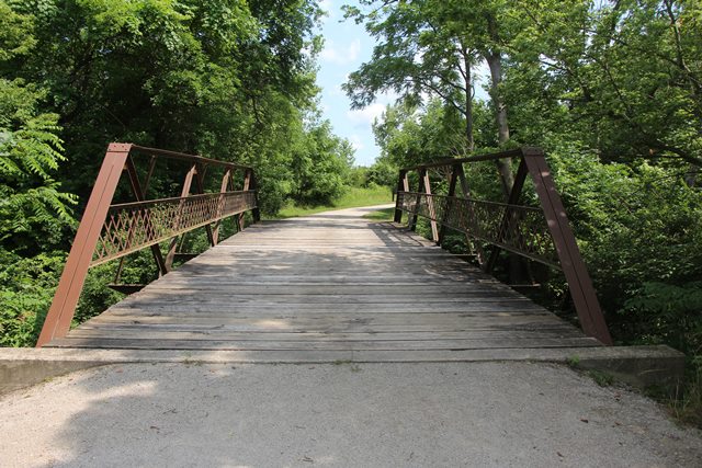
This regionally early example of a rivet-connected highway truss bridge has been relocated and preserved for pedestrian use. The bridge is also noted for its lightweight construction. It has outriggers, but no vertical members in the truss web, which is rare for Warren truss bridges. The bridge originally was located over Hellbranch Run in Pleasant Township and was moved here to the Pickerington Ponds Metro Park in 2004. Length given is an estimate.

Above: Photo from Historic Bridge Inventory showing bridge being moved from its original location.
Information and Findings From Ohio's Historic Bridge InventorySetting/Context The bridge carries a bike path/pedestrian trail over a stream in the Pickerington Ponds Metro Park. It was moved there from Lambert Road over Hellbranch Creek, Franklin County in 2004. Physical Description The 1 span rivet-connected Warren pony truss bridge is lightly composed of angles and built-up members. It has lattice railings. Summary of Significance The 1897 rivet-connected Warren pony truss bridge is the oldest identified example of its type/design in Ohio. It is a significant early example of the truss type/design that would come to dominate truss highway bridge construction (under 100') for the first half of the 20th century. Although relocated, the bridge maintains its integrity of design and materials, and thus still conveys its technological significance. The eligible recommendation of the prior inventory remains appropriate. Justification The bridge is a high level of significance because it is the earliest identified example of a common bridge type/design marking the introduction of an important new technology (riveted connections). Of the over 140 examples built between 1897 and 1960, only 13 predate 1910, which makes early ones not common. Bridge Considered Historic By Survey: Yes |
This bridge is tagged with the following special condition(s): Unorganized Photos
![]()
![]()
![]()
Coordinates (Latitude, Longitude):
Search For Additional Bridge Listings:
Bridgehunter.com: View listed bridges within 0.5 miles (0.8 kilometers) of this bridge.
Bridgehunter.com: View listed bridges within 10 miles (16 kilometers) of this bridge.
Additional Maps:
Google Streetview (If Available)
GeoHack (Additional Links and Coordinates)
Apple Maps (Via DuckDuckGo Search)
Apple Maps (Apple devices only)
Android: Open Location In Your Map or GPS App
Flickr Gallery (Find Nearby Photos)
Wikimedia Commons (Find Nearby Photos)
Directions Via Sygic For Android
Directions Via Sygic For iOS and Android Dolphin Browser
USGS National Map (United States Only)
Historical USGS Topo Maps (United States Only)
Historic Aerials (United States Only)
CalTopo Maps (United States Only)

© Copyright 2003-2025, HistoricBridges.org. All Rights Reserved. Disclaimer: HistoricBridges.org is a volunteer group of private citizens. HistoricBridges.org is NOT a government agency, does not represent or work with any governmental agencies, nor is it in any way associated with any government agency or any non-profit organization. While we strive for accuracy in our factual content, HistoricBridges.org offers no guarantee of accuracy. Information is provided "as is" without warranty of any kind, either expressed or implied. Information could include technical inaccuracies or errors of omission. Opinions and commentary are the opinions of the respective HistoricBridges.org member who made them and do not necessarily represent the views of anyone else, including any outside photographers whose images may appear on the page in which the commentary appears. HistoricBridges.org does not bear any responsibility for any consequences resulting from the use of this or any other HistoricBridges.org information. Owners and users of bridges have the responsibility of correctly following all applicable laws, rules, and regulations, regardless of any HistoricBridges.org information.
![]()