

View Information About HSR Ratings
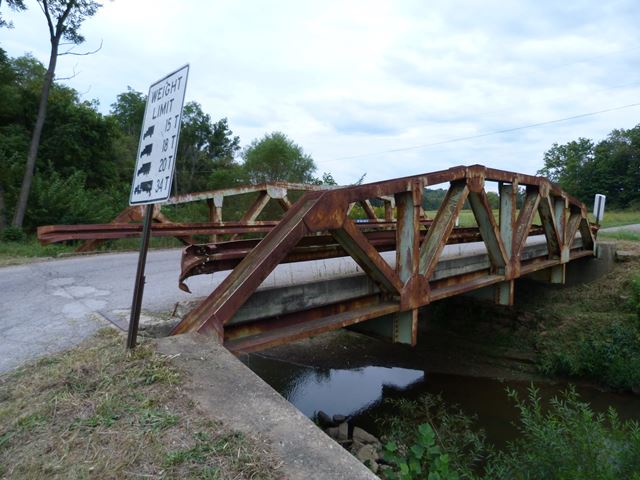
This is a representative example of a fairly old welded truss bridge. Ohio is unusual in that it has a large number of welded truss bridges, having been built from the 1940s to the present day, thanks to a company that is today known as the US Bridge Company and was then known as the Ohio Bridge Corporation.
Information and Findings From Ohio's Historic Bridge InventorySetting/Context The bridge carries a 2 lane road over a stream in a rural area of active farms. Summary of Significance "The one span, 55' long, welded, Warren pony truss with verticals and polygonal upper chords was fabricated by the Ohio Bridge Corporation for the county in 1952. It is finished with a corrugated steel deck and beam guide rail railings inside the truss lines. The abutments are concrete. Ohio Bridge Corporation was started in 1936 as the American Culvert Company at Cambridge by Herman Rogovin, who grew up in Cambridge and attended Case School of Applied Science where he received his BS in mechanical engineering in 1936. American Culvert fabricated and marketed corrugated pipe culverts to the counties and municipalities. The name of the bridge fabrication part of the business was changed to Ohio Bridge Corporation in 1952. While working at the B-29 bomber plant in Cleveland during World War II, Mr. Rogovin formulated ideas about an all-welded pony truss bridge design with rolled section members and welded shop connections that could be erected without expensive false work. He began producing that design in 1946 with the first one being placed at Millersburg (Holmes County). Dardelet bolts, a button-head bolt with a serrated center section were used for field connections. They automatically set themselves when driven in with a sledge and are locked with a nut. The bolts were used to connect sections of the truss lines into a unit and to attach the floorbeams. The pony truss bridge initially conceived by Mr. Rogovin is the one that the company continues to fabricate. Rogovin hired Sid Rockoff of Varo Engineers in Columbus to prepare the calculations and member specifications for standard truss designs in 10-foot increments between 50' to 120' in length. Standard plans were prepared for H12, H15, and H20 loading so the counties and municipalities could purchase the appropriate capacity. Development of weld-connected truss bridges goes hand-in-hand with the development of electric arc-welding. The Westinghouse Electric Co. of Pittsburgh was a leading promoter of the technology and is widely credited with fabricating the nation's first weld-connected truss bridge in 1927-28. The arc-welding industry heavily publicized the technology, and its application to bridges spread rapidly during the 1930s. Pre-World War II examples are not rare. Ohio's 1951-1960 examples are a continuation of a design that was well established in the state during the 1940s. Identified historic examples from 1941-1950 include 8 select Warren pony truss bridges (7 of them with polygonal top chords), 2 Pratt pony truss bridges, and 1 Pratt thru truss bridge. This example, with no innovative or distinctive details, is an example of a common standardized design in the state and is not historically or technologically significant." Bridge Considered Historic By Survey: No |
![]()
![]()
![]()
This historic bridge has been demolished. This map is shown for reference purposes only.
Coordinates (Latitude, Longitude):
Search For Additional Bridge Listings:
Bridgehunter.com: View listed bridges within 0.5 miles (0.8 kilometers) of this bridge.
Bridgehunter.com: View listed bridges within 10 miles (16 kilometers) of this bridge.
Additional Maps:
Google Streetview (If Available)
GeoHack (Additional Links and Coordinates)
Apple Maps (Via DuckDuckGo Search)
Apple Maps (Apple devices only)
Android: Open Location In Your Map or GPS App
Flickr Gallery (Find Nearby Photos)
Wikimedia Commons (Find Nearby Photos)
Directions Via Sygic For Android
Directions Via Sygic For iOS and Android Dolphin Browser
USGS National Map (United States Only)
Historical USGS Topo Maps (United States Only)
Historic Aerials (United States Only)
CalTopo Maps (United States Only)

© Copyright 2003-2025, HistoricBridges.org. All Rights Reserved. Disclaimer: HistoricBridges.org is a volunteer group of private citizens. HistoricBridges.org is NOT a government agency, does not represent or work with any governmental agencies, nor is it in any way associated with any government agency or any non-profit organization. While we strive for accuracy in our factual content, HistoricBridges.org offers no guarantee of accuracy. Information is provided "as is" without warranty of any kind, either expressed or implied. Information could include technical inaccuracies or errors of omission. Opinions and commentary are the opinions of the respective HistoricBridges.org member who made them and do not necessarily represent the views of anyone else, including any outside photographers whose images may appear on the page in which the commentary appears. HistoricBridges.org does not bear any responsibility for any consequences resulting from the use of this or any other HistoricBridges.org information. Owners and users of bridges have the responsibility of correctly following all applicable laws, rules, and regulations, regardless of any HistoricBridges.org information.
![]()