We Recommend:
Bach Steel - Experts at historic truss bridge restoration.
BridgeHunter.com Phase 1 is released to the public! - Visit Now
Bathurst Street Bridge
Sir Isaac Brock Bridge

Primary Photographer(s): Nathan Holth
Bridge Documented: June 20, 2013 and September 27, 2015
Bathurst Street And TTC Streetcar Over Railroad (Go, Canadian National)
Toronto: Toronto City, Ontario: Canada
1931
205.0 Feet (62.5 Meters)
600.0 Feet (182.9 Meters)
Not Available
1 Main Span(s) and 8 Approach Span(s)
Not Applicable

View Information About HSR Ratings
Bridge Documentation
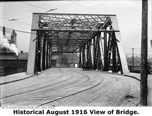
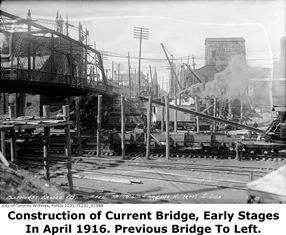
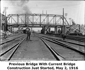
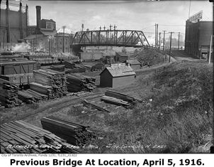
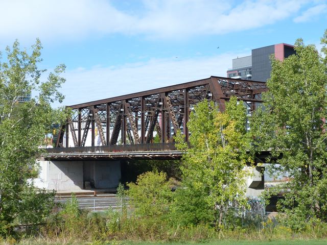
This impressive bridge has an interesting and complicated history. The main span of the bridge is a massive through truss that was originally built over the Humber River in 1903 to serve a railroad line. This is why HistoricBridges.org lists the construction date as 1903, since this is when the main span of the bridge dates to. However, the bridge's history at Bathurst Street begins a little later. In 1916, the truss span was moved and reused at Bathurst Street. At the time, the truss was positioned at the foot of Bathurst Street, but facing southwest. In 1931, the truss was rotated to line up directly with the rest of Bathurst Street as part of a project to extend Bathurst Street to the Lakeshore. At this time, a series of approach spans were also constructed. South of the truss span, the approach system consists of two through plate girder spans, five concrete t-beam spans, and a single steel girder span with concrete encasement. Also dating to 1931 is a six span concrete Garrison Road ramp that leads from the approach spans north down to Fort York. This ramp was built for pedestrians only. In 1997 the 1931 railings on the bridge were removed and replaced with new railings. Today, the bridge's southern approach spans are slated for demolition and replacement. This will destroy all aspects of the 1931 construction, representing a loss of historic integrity on the existing bridge structure as a whole. However, the most significant aspect of the bridge, the 1903 through truss main span, is not slated for demolition. This span is listed as a designated heritage structure by the City of Toronto.
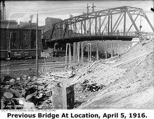
Above: This photo shows initial construction efforts to replace the previous bridge with the 1903 truss at the base of Bathurst Street in 1916.
Above: Photos showing the bridge at Bathurst Street that preceded the installation of the 1903 truss span in 1916.
This bridge is tagged with the following special condition(s): Unorganized Photos
![]()
Photo Galleries and Videos: Bathurst Street Bridge
2013 Bridge Photo-Documentation
Original / Full Size PhotosA collection of overview and detail photos. This gallery offers photos in the highest available resolution and file size in a touch-friendly popup viewer.
Alternatively, Browse Without Using Viewer
![]()
2013 Bridge Photo-Documentation
Mobile Optimized PhotosA collection of overview and detail photos. This gallery features data-friendly, fast-loading photos in a touch-friendly popup viewer.
Alternatively, Browse Without Using Viewer
![]()
2015 Additional Unorganized Photos
Original / Full Size PhotosA supplemental collection of photos that are from additional visit(s) to the bridge and have not been organized or captioned. This gallery offers photos in the highest available resolution and file size in a touch-friendly popup viewer.
Alternatively, Browse Without Using Viewer
![]()
2015 Additional Unorganized Photos
Mobile Optimized PhotosA supplemental collection of photos that are from additional visit(s) to the bridge and have not been organized or captioned. This gallery features data-friendly, fast-loading photos in a touch-friendly popup viewer.
Alternatively, Browse Without Using Viewer
![]()
Maps and Links: Bathurst Street Bridge
Coordinates (Latitude, Longitude):
Search For Additional Bridge Listings:
Additional Maps:
Google Streetview (If Available)
GeoHack (Additional Links and Coordinates)
Apple Maps (Via DuckDuckGo Search)
Apple Maps (Apple devices only)
Android: Open Location In Your Map or GPS App
Flickr Gallery (Find Nearby Photos)
Wikimedia Commons (Find Nearby Photos)
Directions Via Sygic For Android
Directions Via Sygic For iOS and Android Dolphin Browser

