

View Information About HSR Ratings
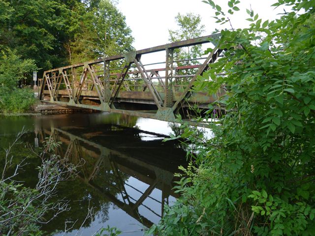
The Birdsall Bridge is an unaltered example of a riveted Warren pony truss. It includes original curbs composed of rolled channels riveted to the truss webs. The bridge's railings are pipe. The Birdsall Bridge crossing dates to at least the 1870s. The existing substructure (abutments) dates to 1930. However, in the 1950s, for unknown reasons, the superstructure of this 1930 bridge was replaced. The replacement superstructure was the existing truss seen today, which was relocated from County Road 2. As such, the original construction date of the truss is not known.
This bridge is apparently slated for demolition and replacement. During the environmental assessment, a "rehabilitation" option was considered for this bridge. However the word "rehabilitation" was used rather loosely in the assessment and the proposed work would only extend the bridge's service life by 10 years. A bridge of the type and in the condition of the Birdsall Bridge should, if the recipient of a proper comprehensive rehabilitation, provide at least 50 additional years of service life. The "rehabilitation" considered in the environmental assessment was in reality only a basic maintenance and repair project. The other alternative considered, demolition and replacement was estimated to cost six times the cost of the "rehabilitation alternative." Had this so-called rehabilitation alternative been properly classified as a "repair" alternative, and a comprehensive rehabilitation alternative considered as well, the comprehensive rehabilitation would likely cost less than replacement but more than repair. Given that this bridge's Average Daily Traffic is a mere 36 vehicles, a less costly comprehensive rehabilitation that would greatly extend the service life, while retaining the heritage bridge (which has a design sufficient for this low volume traffic road) would have been a feasible and prudent alternative.
![]()
![]()
![]()

![]()
This historic bridge has been demolished. This map is shown for reference purposes only.
Coordinates (Latitude, Longitude):
Search For Additional Bridge Listings:
Additional Maps:
Google Streetview (If Available)
GeoHack (Additional Links and Coordinates)
Apple Maps (Via DuckDuckGo Search)
Apple Maps (Apple devices only)
Android: Open Location In Your Map or GPS App
Flickr Gallery (Find Nearby Photos)
Wikimedia Commons (Find Nearby Photos)
Directions Via Sygic For Android
Directions Via Sygic For iOS and Android Dolphin Browser

© Copyright 2003-2026, HistoricBridges.org. All Rights Reserved. Disclaimer: HistoricBridges.org is a volunteer group of private citizens. HistoricBridges.org is NOT a government agency, does not represent or work with any governmental agencies, nor is it in any way associated with any government agency or any non-profit organization. While we strive for accuracy in our factual content, HistoricBridges.org offers no guarantee of accuracy. Information is provided "as is" without warranty of any kind, either expressed or implied. Information could include technical inaccuracies or errors of omission. Opinions and commentary are the opinions of the respective HistoricBridges.org member who made them and do not necessarily represent the views of anyone else, including any outside photographers whose images may appear on the page in which the commentary appears. HistoricBridges.org does not bear any responsibility for any consequences resulting from the use of this or any other HistoricBridges.org information. Owners and users of bridges have the responsibility of correctly following all applicable laws, rules, and regulations, regardless of any HistoricBridges.org information.
![]()