

View Information About HSR Ratings
2024 Update: Excellent news! Apparantly this bridge will be bypassed by a new highway bridge, and preserved in place for non-motorized traffic. See this news article: https://www.cambridgetoday.ca/local-news/city-seeks-heritage-approval-to-convert-black-bridge-road-bridge-to-pedestrian-only-use-8737011
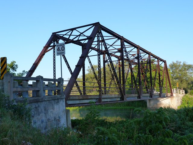
This bridge is a traditionally composed example of a rivet-connected through truss bridge in Ontario. This type of bridge was once common in Ontario but is becoming rare due to demolition and replacement. This bridge was officially designated as a heritage bridge in Ontario, and the Waterloo Region also installed interpretive signage at the bridge to allow visitors to learn more about the bridge. However, the bridge is now facing a risk of demolition and replacement. A study is underway to look at the bridge and the road it serves and according to local news articles one idea is to demolish and replace the one lane heritage bridge with a two lane structure, or even creating a massive four lane bridge. This is deeply concerning and it is hoped that alternatives to demolition would be considered. Options might include constructing a new one lane bridge next to the existing bridge to form a one way couplet of bridges. Also, the bridge could be left as is but with stop light signals added to safely and predictably control the flow of one lane traffic. Finally, the bridge could also be relocated and reused in a new location, perhaps for non-motorized traffic. It should also be noted that a number of local residents are opposed to replacement and are in support of preserving the one lane heritage bridge.
Information and Findings From Waterloo Region Heritage Bridge InventoryWaterloo Region Assigned Heritage Ratings: Overall Score: 62. (Heritage Bridge scores range from 50 up to generally 78) Listed in Top Ten Waterloo Region Heritage Bridge List. Rank: #10 View Heritage Bridge Inventory Data Sheets |
![]()
![]()
![]()

![]()
![]()
Coordinates (Latitude, Longitude):
Search For Additional Bridge Listings:
Additional Maps:
Google Streetview (If Available)
GeoHack (Additional Links and Coordinates)
Apple Maps (Via DuckDuckGo Search)
Apple Maps (Apple devices only)
Android: Open Location In Your Map or GPS App
Flickr Gallery (Find Nearby Photos)
Wikimedia Commons (Find Nearby Photos)
Directions Via Sygic For Android
Directions Via Sygic For iOS and Android Dolphin Browser

© Copyright 2003-2026, HistoricBridges.org. All Rights Reserved. Disclaimer: HistoricBridges.org is a volunteer group of private citizens. HistoricBridges.org is NOT a government agency, does not represent or work with any governmental agencies, nor is it in any way associated with any government agency or any non-profit organization. While we strive for accuracy in our factual content, HistoricBridges.org offers no guarantee of accuracy. Information is provided "as is" without warranty of any kind, either expressed or implied. Information could include technical inaccuracies or errors of omission. Opinions and commentary are the opinions of the respective HistoricBridges.org member who made them and do not necessarily represent the views of anyone else, including any outside photographers whose images may appear on the page in which the commentary appears. HistoricBridges.org does not bear any responsibility for any consequences resulting from the use of this or any other HistoricBridges.org information. Owners and users of bridges have the responsibility of correctly following all applicable laws, rules, and regulations, regardless of any HistoricBridges.org information.
![]()