

View Information About HSR Ratings
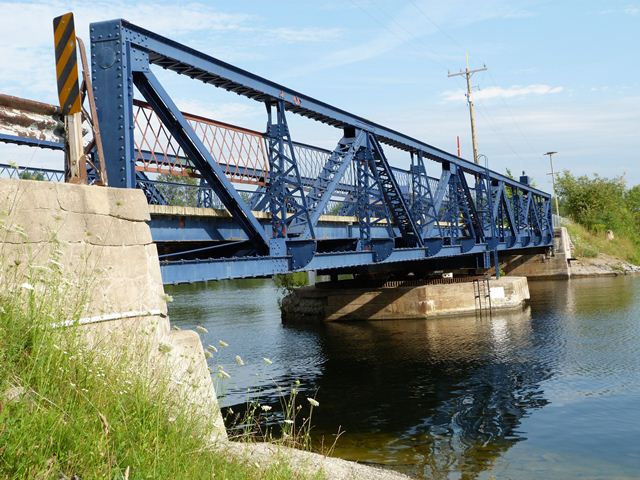
This bridge is an outstanding example of a heritage swing bridge on the Trent-Severn Waterway. The bridge has vertical end posts. This bridge is noted for its high degree of historic integrity with no major alterations to the truss detected. Like many of the Trent Severn Waterway movable bridges, the electrical control equipment appears to have been upgraded. The control equipment in use today is unusual in that it is housed in a simple steel box located next to the bridge. There is no "bridge tender house" as it typically found with movable bridges within which is housed the control equipment. There is a shelter for the bridge tender near where the control equipment is located, but no control equipment is located within this building.
The truss appears to remain in good condition. However, the concrete pier shows signs of deterioration.
The Trent Severn Waterway is a National Historic Site of Canada. As such, one would think that all the heritage structures that contribute to the heritage of the greater waterway would receive the highest preservation priority. The Trent Severn Waterway has had a number of heritage bridges crossing it. However, some of these bridges have been demolished and replaced, in particular, swing bridges. The replacements often are given a design that simulates the appearance of the heritage bridge. However such efforts cannot be considered to be a form of preservation, nor can the replacement bridges be described as heritage bridges. Only original bridges like the Boundary Channel 44 Bridge can be considered heritage bridges. With the population of such bridges on the waterway decreasing, it is hoped that a high priority will be given to preserving and rehabilitating this bridge, with a focus placed on maintaining original bridge material and design, particularly with the significant metal truss superstructure.
![]()
![]()
![]()

![]()
Coordinates (Latitude, Longitude):
Search For Additional Bridge Listings:
Additional Maps:
Google Streetview (If Available)
GeoHack (Additional Links and Coordinates)
Apple Maps (Via DuckDuckGo Search)
Apple Maps (Apple devices only)
Android: Open Location In Your Map or GPS App
Flickr Gallery (Find Nearby Photos)
Wikimedia Commons (Find Nearby Photos)
Directions Via Sygic For Android
Directions Via Sygic For iOS and Android Dolphin Browser

© Copyright 2003-2026, HistoricBridges.org. All Rights Reserved. Disclaimer: HistoricBridges.org is a volunteer group of private citizens. HistoricBridges.org is NOT a government agency, does not represent or work with any governmental agencies, nor is it in any way associated with any government agency or any non-profit organization. While we strive for accuracy in our factual content, HistoricBridges.org offers no guarantee of accuracy. Information is provided "as is" without warranty of any kind, either expressed or implied. Information could include technical inaccuracies or errors of omission. Opinions and commentary are the opinions of the respective HistoricBridges.org member who made them and do not necessarily represent the views of anyone else, including any outside photographers whose images may appear on the page in which the commentary appears. HistoricBridges.org does not bear any responsibility for any consequences resulting from the use of this or any other HistoricBridges.org information. Owners and users of bridges have the responsibility of correctly following all applicable laws, rules, and regulations, regardless of any HistoricBridges.org information.
![]()