We Recommend:
Bach Steel - Experts at historic truss bridge restoration.
BridgeHunter.com Phase 1 is released to the public! - Visit Now
Chambers Bridge
Pilkington-Woolwich Bridge

Primary Photographer(s): Nathan Holth and Rick McOmber
Bridge Documented: July 21, 2012 and April 22, 2021
Woolwich Township: Waterloo Region, Ontario: Canada
By Builder/Contractor: Unknown
Not Available or Not Applicable
Not Available
155.8 Feet (47.5 Meters)
14 Feet (4.27 Meters)
1 Main Span(s)
Not Applicable

View Information About HSR Ratings
Bridge Documentation
This bridge's future is at risk!
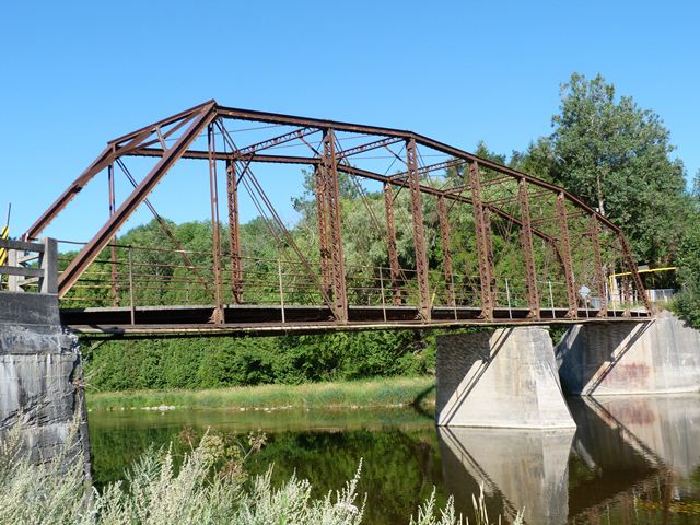
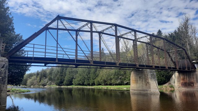
Bridge Status: Slated for demolition with no replacement!2020 Update: This bridge is now slated for demolition with no replacement bridge whatsoever. Given that pin-connected truss bridges are exceedingly rare in Ontario, and pin-connected Camelback/Parker truss bridges even moreso, this is a devastating loss to Ontario's cultural heritage. Similar plans to demolish the even rarer Winterbourne Bridge in the Waterloo Region must be halted immediately to prevent a total loss of this bridge type in the region!
This bridge is one of several Camelback truss bridges remaining in Waterloo Region. Outside of Waterloo Region, this design is extremely rare in Ontario.
The Waterloo Region Heritage Bridge Inventory suggests that this bridge was built in 1930 and relocated to this site in 1946. However, the design of this bridge is nearly identical to the Winterbourne Bridge which dates to 1913. The similarities to Winterbourne Bridge, plus the fact that pin-connected truss bridges were almost never built after 1915 suggests that there is a problem with the 1930 theory. It is more likely that the truss seen here was built ca. 1913 and relocated to the Chambers Bridge site either in 1930 or 1946. What is clear is that the bridge was moved to the Chambers Bridge site to replace a previous bridge. A concrete pier from a previous bridge remains unused in the middle of the river. The concrete pier indicates that the previous bridge was a two-span bridge.
It should be noted that if the bridge does date to ca. 1913 as HistoricBridges.org suggests, this would increase the heritage score for the bridge.
Don Drews created a video slideshow of the bridge which is available on YouTube here.
Information and Findings From Waterloo Region Heritage Bridge InventoryWaterloo Region Assigned Heritage Ratings: Overall Score: 48. (Heritage Bridge scores range from 50 up to generally 78) Not Listed in Top Ten Waterloo Region Heritage Bridge List. View Heritage Bridge Inventory Data Sheets |
This bridge is tagged with the following special condition(s): Unorganized Photos
![]()
Photo Galleries and Videos: Chambers Bridge
Bridge Photo-Documentation
Original / Full Size PhotosA collection of overview and detail photos. This gallery offers photos in the highest available resolution and file size in a touch-friendly popup viewer.
Alternatively, Browse Without Using Viewer
![]()
Bridge Photo-Documentation
Mobile Optimized PhotosA collection of overview and detail photos. This gallery features data-friendly, fast-loading photos in a touch-friendly popup viewer.
Alternatively, Browse Without Using Viewer
![]()
Additional Unorganized Photos
Original / Full Size PhotosA supplemental collection of photos that are from additional visit(s) to the bridge and have not been organized or captioned. This gallery offers photos in the highest available resolution and file size in a touch-friendly popup viewer.
Alternatively, Browse Without Using Viewer
![]()
Additional Unorganized Photos
Mobile Optimized PhotosA supplemental collection of photos that are from additional visit(s) to the bridge and have not been organized or captioned. This gallery features data-friendly, fast-loading photos in a touch-friendly popup viewer.
Alternatively, Browse Without Using Viewer
![]()
Eastbound Crossing
Full Motion VideoStreaming video of the bridge. Also includes a higher quality downloadable video for greater clarity or offline viewing.
![]()
Westbound Crossing
Full Motion VideoStreaming video of the bridge. Also includes a higher quality downloadable video for greater clarity or offline viewing.
![]()
Maps and Links: Chambers Bridge
Coordinates (Latitude, Longitude):
Search For Additional Bridge Listings:
Additional Maps:
Google Streetview (If Available)
GeoHack (Additional Links and Coordinates)
Apple Maps (Via DuckDuckGo Search)
Apple Maps (Apple devices only)
Android: Open Location In Your Map or GPS App
Flickr Gallery (Find Nearby Photos)
Wikimedia Commons (Find Nearby Photos)
Directions Via Sygic For Android
Directions Via Sygic For iOS and Android Dolphin Browser


