

View Information About HSR Ratings
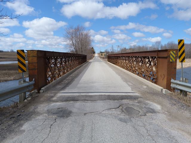
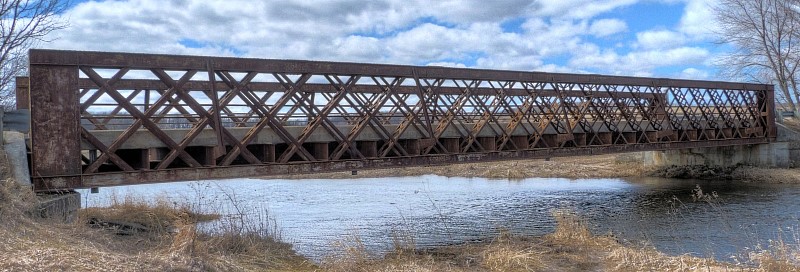
This bridge is nearly identical to the Dudgeon Bridge's truss span seen on, and the two truss spans may share a common history, since the Dudgeon Bridge's truss span is a relocated span, this truss on Concession Road 8 may be similarly relocated. The Dudgeon Bridge's lattice truss span was reportedly a former railway span that was reconfigured for highway use. Both spans may have come from the same original bridge, in an unknown location. Despite the similarities of these two bridges, both bridges are otherwise unique among the thousands of bridges in Canada and the United States on HistoricBridges.org. These two bridges may be the only examples of their kind in North America. Quadruple Warren truss bridges in North America generally are found as through or deck truss bridges, not pony truss bridges. The bridges, with their lattice pony truss configuration and unusual vertical end posts, are strongly reminiscent of a European style of bridge known as a lattice girder bridge. Europe's lattice girder bridges generally will have lighter and more numerous diagonal members forming a very tight lattice, but the overall visual appearance is strikingly similar. European lattice girder bridges are often pony truss bridges.
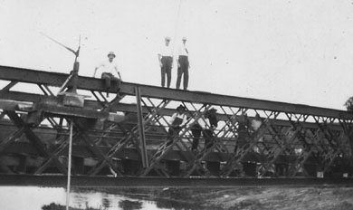
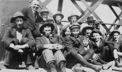
Please visit the Dudgeon Bridge page for a more detailed discussion about these two bridges and the features that make them unique and among the most significant heritage bridges in Ontario, a distinction that it is sadly unrecognized by local residents and government, particularly with this bridge. The bridge did make an appearance in an undated photo on a website with family photos from the collection of Catherine Taylor-Lamb and Lizzie Lamb-Kincaid who apparently had a farm near the bridge. The photo below was captioned as "new bridge." It was also labeled Gregg's Bridge, which may be the local name for this bridge.
Unlike the Dudgeon Bridge, the Concession Road 8 shows some empty rivet holes, located on a couple of the end posts. These empty holes show where a diagonal member used to be located but is today missing. It is not known why the diagonal member is missing, and whether it has anything to do with the relocation of the bridge.
![]()
![]()
![]()
Coordinates (Latitude, Longitude):
Search For Additional Bridge Listings:
Additional Maps:
Google Streetview (If Available)
GeoHack (Additional Links and Coordinates)
Apple Maps (Via DuckDuckGo Search)
Apple Maps (Apple devices only)
Android: Open Location In Your Map or GPS App
Flickr Gallery (Find Nearby Photos)
Wikimedia Commons (Find Nearby Photos)
Directions Via Sygic For Android
Directions Via Sygic For iOS and Android Dolphin Browser

© Copyright 2003-2026, HistoricBridges.org. All Rights Reserved. Disclaimer: HistoricBridges.org is a volunteer group of private citizens. HistoricBridges.org is NOT a government agency, does not represent or work with any governmental agencies, nor is it in any way associated with any government agency or any non-profit organization. While we strive for accuracy in our factual content, HistoricBridges.org offers no guarantee of accuracy. Information is provided "as is" without warranty of any kind, either expressed or implied. Information could include technical inaccuracies or errors of omission. Opinions and commentary are the opinions of the respective HistoricBridges.org member who made them and do not necessarily represent the views of anyone else, including any outside photographers whose images may appear on the page in which the commentary appears. HistoricBridges.org does not bear any responsibility for any consequences resulting from the use of this or any other HistoricBridges.org information. Owners and users of bridges have the responsibility of correctly following all applicable laws, rules, and regulations, regardless of any HistoricBridges.org information.
![]()