We Recommend:
Bach Steel - Experts at historic truss bridge restoration.
BridgeHunter.com Phase 1 is released to the public! - Visit Now
Dorset Bridge

Primary Photographer(s): Fred Heinzler and Dorset Community Partnership Group
Bridge Documented: April 15, 2015
Dorset: Muskoka District, Ontario and Haliburton County, Ontario: Canada
Metal 6 Panel Rivet-Connected Warren Pony Truss, Fixed and Approach Spans: Metal Stringer (Multi-Beam), Fixed
1907 By Builder/Contractor: Western Bridge and Equipment Company of Chatham, Ontario
2017
Not Available
Not Available
Not Available
1 Main Span(s) and 2 Approach Span(s)
Not Applicable

View Information About HSR Ratings
Bridge Documentation
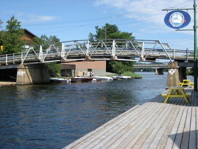
This is a very unusual bridge because of its "humpback" shape. Both the deck and the truss share the same humpback or arched shape to them. The design of the bridge would have increased clearance for boats, while also eliminating the need for a long approach ramp leading up to the bridge.
The humped shape is extremely rare among truss bridges, especially when the hump is all within a single span, not over several non-humpback spans like the Waubaushene Bridge.
This bridge is also noted for being built by what is today a little-known bridge builder, Western Bridge and Equipment of Chatham, Ontario.
The bridge has been heavily repaired over the years, and numerous rivets have been replaced with bolts, and additional steel has been bolted onto the bridge for added strength. Despite alteration, the bridge retains the unusual humpback design and as such should be considered a noteworthy heritage bridge.
A 1914 construction date was provided by the Dorset Community Partnership Group who indicated that this bridge was built to accommodate higher waters from construction of a dam built at the same time. However, this sheet from the 1908 Annual Department of Public Works shows a contract for $3,480 in 1907 entered into with Western Bridge and Equipment of Chatham, Ontario to supply and erect steel superstructure of a bridge over the "Burnt River" in the Village of Dorset between Districts of Muskoka and Haliburton. It is therefore possible that this truss dates to 1907-1908 and that it was simply raised (perhaps requiring replacement or substantial alteration of the concrete piers and abutments) in 1914.
Thanks to Fred Heinzler, the Dorset Community Partnership Group, and the community run, volunteer sponsored website www.DorsetCanada.com for providing information and photos about this bridge.
![]()
Photo Galleries and Videos: Dorset Bridge
Bridge Photo-Documentation
Original / Full Size PhotosA collection of overview and detail photos. This gallery offers photos in the highest available resolution and file size in a touch-friendly popup viewer.
Alternatively, Browse Without Using Viewer
![]()
Bridge Photo-Documentation
Mobile Optimized PhotosA collection of overview and detail photos. This gallery features data-friendly, fast-loading photos in a touch-friendly popup viewer.
Alternatively, Browse Without Using Viewer
![]()
Maps and Links: Dorset Bridge
Coordinates (Latitude, Longitude):
Search For Additional Bridge Listings:
Additional Maps:
Google Streetview (If Available)
GeoHack (Additional Links and Coordinates)
Apple Maps (Via DuckDuckGo Search)
Apple Maps (Apple devices only)
Android: Open Location In Your Map or GPS App
Flickr Gallery (Find Nearby Photos)
Wikimedia Commons (Find Nearby Photos)
Directions Via Sygic For Android
Directions Via Sygic For iOS and Android Dolphin Browser

