We Recommend:
Bach Steel - Experts at historic truss bridge restoration.
BridgeHunter.com Phase 1 is released to the public! - Visit Now
Elgin Road Bridge

Primary Photographer(s): Nathan Holth
Bridge Documented: April 12, 2011
Elgin Road (KH-73) Over KH-401 (King's Highway 401, MacDonald-Cartier Freeway)
Rural: Middlesex County, Ontario: Canada
1988
108.3 Feet (33 Meters)
Not Available
Not Available
1 Main Span(s)
Not Applicable

View Information About HSR Ratings
Bridge Documentation
This bridge no longer exists!
Bridge Status: Demolished and replaced.Information from Ontario Bridge Inventory: Bridge width: 17.2 meters.
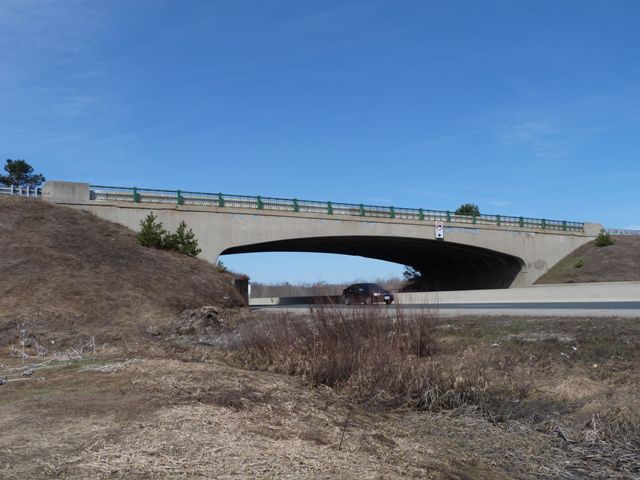
There are a number of graceful rigid-frame structures remaining on Highway 401. These structures, with their attractive arch shape, and their ornamental period railings are still relatively prolific on Highway 401, but are otherwise rare examples of old overpass construction. They also are rare examples of expressway overpasses that actually have aesthetic qualities to them. These overpasses make an interesting comparison to the historic Christina Street Bridge in Sarnia. The Christina Street Bridge has two spans, which is a more typical configuration for an expressway overpass in the greater context of more modern overpasses and overpasses in other provinces and states. In contrast, these Highway 401 structures sweep over the highway in a single span. Although they utilize a different structure type, in a loose way, the architecture of all these Ontario bridges is similar to that seen in Michigan with curved t-beam bridges such as the 6th Street Bridge, in terms of an arched beam and the same general design of railing.
This bridge had concrete barriers added to the bridge, sometime between 2007 and 2011. Fortunately however, the original decorative railings were left in place.
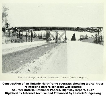
These rigid-frame bridges on Ontario's freeways do not use rebar type reinforcing rods that are associated with the majority of reinforced concrete bridges. Instead, these bridges use a serious of parallel continuous trusswork for reinforcing. The reinforcing is quite striking and can be seen in the historical photo to the left showing the construction of another similar overpass. The use of solid trusswork for reinforcing was not something new when Highway 401 was built. Rather it was a technique that was most common in the very early years of concrete in the first decade of the 20th Century, where patented designs like Melan reinforcing or even Marsh arch bridges used continuous, solid steel trusses and ribs to form the reinforcing.
![]()
Photo Galleries and Videos: Elgin Road Bridge
Bridge Photo-Documentation
Original / Full Size PhotosA collection of overview and detail photos. This gallery offers photos in the highest available resolution and file size in a touch-friendly popup viewer.
Alternatively, Browse Without Using Viewer
![]()
Bridge Photo-Documentation
Mobile Optimized PhotosA collection of overview and detail photos. This gallery features data-friendly, fast-loading photos in a touch-friendly popup viewer.
Alternatively, Browse Without Using Viewer
![]()
Maps and Links: Elgin Road Bridge
This historic bridge has been demolished. This map is shown for reference purposes only.
Coordinates (Latitude, Longitude):
Search For Additional Bridge Listings:
Additional Maps:
Google Streetview (If Available)
GeoHack (Additional Links and Coordinates)
Apple Maps (Via DuckDuckGo Search)
Apple Maps (Apple devices only)
Android: Open Location In Your Map or GPS App
Flickr Gallery (Find Nearby Photos)
Wikimedia Commons (Find Nearby Photos)
Directions Via Sygic For Android
Directions Via Sygic For iOS and Android Dolphin Browser


