We Recommend:
Bach Steel - Experts at historic truss bridge restoration.
BridgeHunter.com Phase 1 is released to the public! - Visit Now
Heffernan Street Bridge

Primary Photographer(s): Nathan Holth and Rick McOmber
Bridge Documented: July 19, 2013
Heffernan Street (Pedestrian Walkway) Over Speed River and Railroad (Royal Recreation Rail-Trail)
Guelph: Wellington County, Ontario: Canada
1914 By Builder/Contractor: Galbraith and Cate and Engineer/Design: Ernest E. Clawson
1991
Not Available
490.0 Feet (149.4 Meters)
Not Available
2 Main Span(s) and 9 Approach Span(s)
Not Applicable

View Information About HSR Ratings
Bridge Documentation
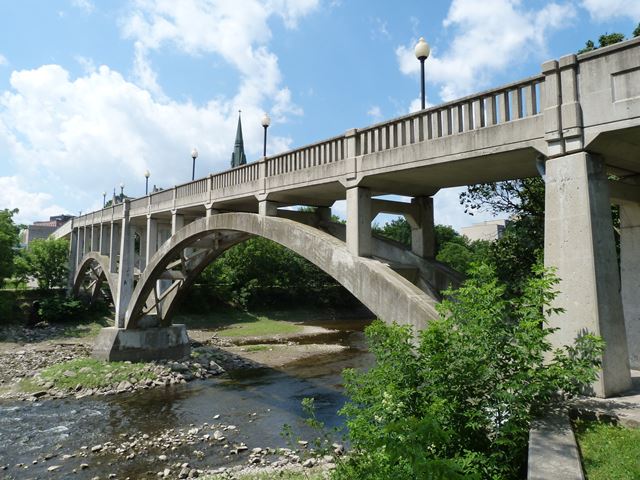
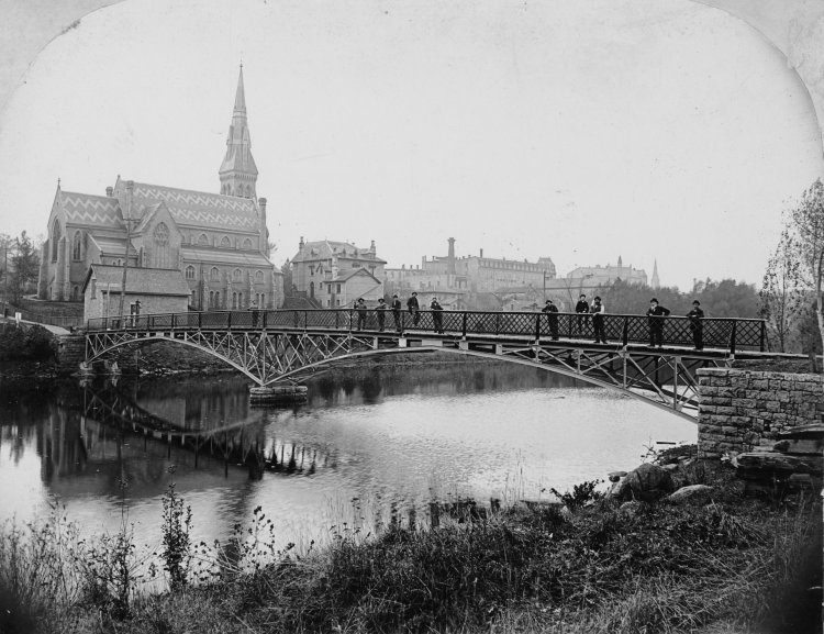
This is a very unique foot bridge. The bridge was designed to provide pedestrian access over both the Speed River and a railway, which today includes a non-motorized trail. It consists of two main open spandrel deck arch spans that cross over the Speed River, with additional concrete slab approach spans at each end, including concrete slab spans over where the railway was located. The highest point on the bridge was the crossing over the railroad, so the bridge has the unusual detail that the main spans have a deck constructed with a grade, giving the bridge a unique appearance. The bridge was extensively reconstructed in 1991. It appears that everything above the arch ribs including columns, deck, and railings were replaced at this time. The railings seen appear to replicate to some extent the original design. Despite the loss of original material, the bridge remains a noteworthy heritage structure because of its unusual design. It replaced a previous metal arch foot bridge at this location which likely dated to 1881. The below photo was taken ca. 1896 and shows the previous bridge at this location. Source: Guelph Public Library Item Number C6-0-0-0-0-1134

Information and Findings From Canada's Historic PlacesDescription of Historic Place The Heffernan Street Footbridge spans the Speed River, in downtown Guelph, from Arthur Street to Woolwich Street, rising over Heffernan Street and spanning the Speed River. The two-span, reinforced concrete,
open-spandrel arch bridge was built in 1914. Heritage Value Built in 1914 to replace an earlier metal arch bridge, the Heffernan Street Footbridge is part of a pedestrian route which was developed in the mid 19th Century, from St. George's Ward residential neighbourhood
to the City of Guelph's downtown commercial centre. A footbridge has been in place at this site since 1881. Character-Defining Elements Character defining elements that contribute to the heritage value of the Heffernan Street Footbridge include its: Heritage Designation and Type: Yes, Municipal Heritage Designation (Part IV) |
![]()
Photo Galleries and Videos: Heffernan Street Bridge
Bridge Photo-Documentation
Original / Full Size PhotosA collection of overview and detail photos. This gallery offers photos in the highest available resolution and file size in a touch-friendly popup viewer.
Alternatively, Browse Without Using Viewer
![]()
Bridge Photo-Documentation
Mobile Optimized PhotosA collection of overview and detail photos. This gallery features data-friendly, fast-loading photos in a touch-friendly popup viewer.
Alternatively, Browse Without Using Viewer
![]()
Maps and Links: Heffernan Street Bridge
Coordinates (Latitude, Longitude):
Search For Additional Bridge Listings:
Additional Maps:
Google Streetview (If Available)
GeoHack (Additional Links and Coordinates)
Apple Maps (Via DuckDuckGo Search)
Apple Maps (Apple devices only)
Android: Open Location In Your Map or GPS App
Flickr Gallery (Find Nearby Photos)
Wikimedia Commons (Find Nearby Photos)
Directions Via Sygic For Android
Directions Via Sygic For iOS and Android Dolphin Browser

