

View Information About HSR Ratings
Updates: In 2019, Eric May reports that this bridge has been blocked to through traffic with a barrier. As of August 20, 2020, the bridge is definitely being torn down. The house it served was torn down at some point in the past two weeks. The bridge is due to be demolished and a turn around built on its west end by October. There is already considerable steel support scaffolding under the bridge. It probably has less than a month at this point.
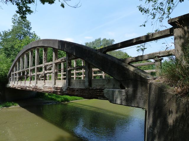
If the 1918 construction date given for this bridge is correct, this is among the oldest examples of a concrete "rainbow" bowstring arch bridge in Ontario.
This bridge serves a road that ends immediately east of the bridge at a private home's driveway. As such, the bridge normally only serves vehicular traffic seeking to access this single home. However the bridge is used by non-motorized traffic, which can continue east from the bridge through to St. Padre Pio Gardens. Humber Bridge Trail and St. Padre Pio Gardens appear to have originally been an old alignment for Major Mackenzie Drive. This bridge is one of only four rainbow (bowstring) type arch bridges on the Humber River. The bridge displays good historic integrity with no major alterations, but is in extremely poor condition structurally. Severe spalling and other deterioration was noted on the hangers, railings, as well as the bottom chord (tie). The main arch ribs appeared to be in fair to good condition however. The worst deterioration is found on the hangers. In fact one hanger has a section that has absolutely no concrete remaining, with only the rusted reinforcing rods remaining!
An Environmental Assessment has been in progress for this heritage bridge. A number of alternatives for improving this crossing were studied, many of which included undesirable demolition of the heritage bridge. However the most recent study reports indicated that rehabilitation was the preferred alternative for the bridge. It is hoped that a project to rehabilitate the existing bridge will move forward. It is important that preservation move forward before it deteriorates to the point where no original material of the bridge can be repaired.
![]()
![]()
![]()
This historic bridge has been demolished. This map is shown for reference purposes only.
Coordinates (Latitude, Longitude):
Search For Additional Bridge Listings:
Additional Maps:
Google Streetview (If Available)
GeoHack (Additional Links and Coordinates)
Apple Maps (Via DuckDuckGo Search)
Apple Maps (Apple devices only)
Android: Open Location In Your Map or GPS App
Flickr Gallery (Find Nearby Photos)
Wikimedia Commons (Find Nearby Photos)
Directions Via Sygic For Android
Directions Via Sygic For iOS and Android Dolphin Browser

© Copyright 2003-2026, HistoricBridges.org. All Rights Reserved. Disclaimer: HistoricBridges.org is a volunteer group of private citizens. HistoricBridges.org is NOT a government agency, does not represent or work with any governmental agencies, nor is it in any way associated with any government agency or any non-profit organization. While we strive for accuracy in our factual content, HistoricBridges.org offers no guarantee of accuracy. Information is provided "as is" without warranty of any kind, either expressed or implied. Information could include technical inaccuracies or errors of omission. Opinions and commentary are the opinions of the respective HistoricBridges.org member who made them and do not necessarily represent the views of anyone else, including any outside photographers whose images may appear on the page in which the commentary appears. HistoricBridges.org does not bear any responsibility for any consequences resulting from the use of this or any other HistoricBridges.org information. Owners and users of bridges have the responsibility of correctly following all applicable laws, rules, and regulations, regardless of any HistoricBridges.org information.
![]()